Mull of Galloway circular
Dumfries and Galloway Walk
County/Area - Dumfries and Galloway
Author - Lou Johnson
Length - 6.0 miles / 9.8 km Ascent - 500 feet / 152 metres
Time - 3 hours 30 minutes Grade - easy
Walk Route Description
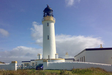
Click image to see photo description.
The Mull of Galloway is the southernmost point of Scotland. There is a lighthouse is built in 1830 by engineer Robert Stevenson. The area is a nature reserve managed by the RSPB. The walk follows the south facing cliffs before crossing the peninsula to return along the east coast. As with many coastal walks, expect to encounter some short ascents during the walk.
The start is the small car park close to the lighthouse (grid ref. NX154304). From the parking area follow the coast path west (with the sea to your left) and continue along the cliffs to reach the access road to the peninsula. Here bear left towards West Cairngaan and continue along the coast for about three quarters of a mile before turning inland towards West Cairgaan. There is a waymark at the junction.
Heading north follow the clear path passing West Cairngaan on your left until you near East Cairngaan Farm (grid ref. NX130323) also on your left. Turn right here (east) and follow the path alongside a burn at first to reach a road (grid ref. NX135325). Cross the road and continue east along the banks of Kirk Burn to reach the coast. Turn right along the coast path and walk south towards to the Mull of Galloway.
Returning to the road, bear left and either follow the road back to the start or take the path on your left which offers better views of the cliffs and sea.
Maps 

| Ordnance Survey Explorer 309 | Sheet Map | 1:25k | BUY |
| Anquet OS Explorer 309 | Digital Map | 1:25k | BUY |
| Ordnance Survey Digital Map Subscription | |||
| Latest Ordnance Survey Discounts | |||
Other walks nearby
| Walk 2068 | Maxwell's Otter and Monreith Beach | easy | 6.0 miles |
| Walk 2658 | The Machars Peninsula - St Ninian's Cave | easy | 2.0 miles |
| Walk 2623 | Merrick from Glen Trool | mod/hard | 8.0 miles |
| Walk 3316 | Rockcliffe to Kippford | easy | 3.0 miles |
| Walk 3290 | Rockcliffe to Sandyhills | easy/mod | 5.0 miles |
| Walk 3558 | St Bees to Whitehaven coast path | easy/mod | 7.4 miles |
| Walk 1745 | Grike and Caw Fell from Kinniside Stone Circle | mod/hard | 13.5 miles |
| Walk 1671 | Grike & Crag Fell | easy/mod | 6.6 miles |
| Walk 2058 | Ennerdale Skyline incl. Steeple & other fells | mod/hard | 13.8 miles |
| Walk 3667 | Ennerdale Water Circular | moderate | 7.1 miles |
