Ben Wyvis (western approach)
Highland Walk
County/Area - Highland - Central Highland
Author - Lou Johnson
Length - 8.0 miles / 13 km Ascent - 3100 feet / 939 metres
Time - 7 hours 10 minutes Grade - mod/hard
Walk Route Description
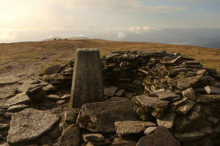
Click image to see photo description.
This ascent of Ben Wyvis (Glas Leathad Mor) is an excellent walk to this popular Munro which rises to 1046 metres. The route benefits from an excellent path so in fine weather navigation skills are not required. The quality of the path makes this one of the easier Munros (Scottish hill over 3000 feet) to climb. From the summit you can enjoy excellent views which include the surrounding Highlands and the Cromatry Firth.
The start is the Ben Wyvis car park (grid ref. NH410671) on the east side of the A835 from Inverness to Ullapool. After parking walk north along a track that runs parallel to the main road. Continue across a footbridge to pass through a gate. The path, heading south-east, passes through the Garbat Forest with a burn on your right. Continue across a track and continue a steady climb to exit the forest onto open hillside.
The clear path begins to zigzag up the hill easing the gradient. Above the zigzags a series of stone steps help on the steeper sections and with steady progress uphill you soon arrive at the top of the climb on An Cabar. With the hard work complete, the onward route follows a ridge. Walkers are requested to use the central path to avoid damaging the fragile vegetation. Stay on the broad ridge heading north-east for about two kilometres passing another cairn at the mid-point. A final steady ascent leads to the walled OS trig column on the summit of Ben Wyvis. After enjoying the extensive view, retrace your steps back down to the car park.
Maps 

| Ordnance Survey Explorer 437 | Sheet Map | 1:25k | BUY |
| Anquet OS Explorer 437 | Digital Map | 1:25k | BUY |
| Ordnance Survey Digital Map Subscription | |||
| Latest Ordnance Survey Discounts | |||
Other walks nearby
| Walk 1530 | Little Wyvis ascent from near Garve | moderate | 6.4 miles |
| Walk 2106 | Ullapool - a Munro Quartet including Beinn Dearg | very hard | 16.0 miles |
| Walk 2504 | Struie circular | easy/mod | 4.5 miles |
| Walk 1305 | Sgurr nan Fhir Duibhe from Kinlochewe | hard | 7.5 miles |
| Walk 1347 | Meall a' Ghiubhais from Kinlochewe | moderate | 8.0 miles |
| Walk 1018 | Beinn Ghobhlach | moderate | 6.0 miles |
| Walk 2693 | Achnashellach & Easan Dorcha | moderate | 8.8 miles |
| Walk 2116 | Beinn Eighe Route Guide | hard | 13.0 miles |
| Walk 2117 | Beinn Eighe - West to East traverse, Torridon | hard | 12.3 miles |
| Walk 2118 | Beinn Eighe traverse including Black Carls, Torridon | hard | 12.5 miles |
Recommended Books & eBooks
Walking in Torridon
 This guidebook contains 52 day walks in Torridon, a remote and much-loved area of the Scottish Highlands. Based around Shieldaig and Slioch, the routes are split into 3 sections: easy walks, long and high level walks and mountain ascents over 2000ft including 9 Munros, and 5 outline suggestions for major ridge walks.
More information
Skye's Cuillin Ridge Traverse
 This 2-volume set provides all the information required to complete the main ridge traverse on Skye's Black Cuillin. Strategy, gear, training, navigation and logistics are covered, and 10 classic scrambles are described. A lightweight second guidebook gives the scrambler detailed maps, topos and route description for the ridge traverse itself.
More information
