Beinn Eighe Route Guide
Highland Walk
County/Area - Highland - Central Highland
Author - Stephen Boulton
Length - 13.0 miles / 21.1 km Ascent - 4800 feet / 1455 metres
Time - 11 hours 20 minutes Grade - hard
Walk Route Description
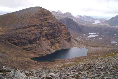
Click image to visit gallery of 6 images.
The longest route option is about 18 km or 13 miles, mostly over rocky terrain when up high. It should be saved for a clear day as the ridge is spectacular and the views of Liathach, Glen Torridon and the surrounding mountains should not be missed.
This walk description summarises the various options and with individual descriptions available and these are indicated on the outline route map. The four routes considered are as follows :
Walk 2117 The West to East traverse of Beinn Eighe (excluding the Black Carls)
Walk 2118 The West to East traverse of Beinn Eighe (including the Black Carls)
Walk 2119 The Munros of Beinn Eighe & Sail Mhor
Walk 2120 The Munros of Beinn Eighe
For the complete ridge you will need two cars, or you'll face a long walk (c.9 km) back down the A896 road through Glen Torridon to retrieve your car at the end of the day. if you can, park one on the A896 near Cromasaig, just south of Kinlochewe. There's not much in the way of parking spaces here without obstructing a passing place, so it might be best to leave the car in Kinlochewe itself, this adds about an extra 1 km to the walk.
Drive the other car down the glen to the car park near the bridge over the Allt a'Choire Dhuibh Mhor. This burn runs between Liathach and Beinn Eighe before passing under the road. Follow the signposted path to the Coire Mhic Nobuil. This curves north and heads between the east end of Liathach on your left and the west end of Beinn Eighe on the right.
Shortly before the Lochan a'Choire Dhuibh head right (north) on a path which contours around the base of Sail Mhor on your right to reach the outflow of the Loch Coire Mhic Fhearchair. Climb up the stone path to reach the loch, whereupon is revealed the great sight of the Triple Buttress of Beinn Eighe, across the loch under the summit of Coinneach Mhor. This is a great place to stop for a break, a remote and peaceful location.
Cross the loch outflow and head around the east side of the loch, following the path which brings you to below the Triple Buttress before it strikes off left and climbs past several other lochans to reach the foot of a scree slope up to the ridge. It may be easier to scramble up the rocks to the right of the scree slope rather than up the scree itself. It looks steep when first viewed from beside the loch outflow, but up closer it's an easy scramble.
Upon reaching the ridge admire the view ahead to Spidean Coire nan Clach, the second of Beinn Eighe's two Munros, before turning left to head up the short distance, about 1 km over easy ground, to reach Ruadh-stac Mor, the other Munro. From here fine views north are unveiled, across to Coigach in the north and Slioch round to the north east. Retrace your steps to the bealach where you emerged from the scree scramble. Then climb ahead of you (south) to reach a cairn just to the east of Coinneach Mhor. An optional add-on of about 3 km here is to turn right and walk to the actual summit of Coinneach Mhor and on around to the top of Sail Mhor which is a Munro Top. If you do this, retrace your steps to this cairn before continuing the walk eastwards along the main ridge of Beinn Eighe. Superb views of the back of Liathach emerge on your right, well worth stopping to have a look at.
The rocky ridge undulates but it is fairly easy going to rise to Spidean Coire nan Clach. The trig point is not at the highest point of this Munro. If you have had enough it's possible to descend south east from here via Coire an Laoigh, but this path will bring you out to the road halfway between your two means of transport. To continue the ridge walk head further east across a bealach to reach Sgurr Ban, and then over another rocky dip to climb to Sgurr nan Fhir Duibhe. if you have chosen your day well then superb views accompany you all the way. At Sgurr nan Fhir Duibhe you have two choices. Continuing eastwards down the right arm of Coire Domhain avoids the scramble over the Black Carls of Beinn Eighe and will bring you out on the road south of Cromasaig. You might have to make your own path over the tussocky grass for the last 2km or so, however, and climb a deer fence. Much more exciting is to head north from Sgurr nan Fhir Duibhe to cross the Black Carls. Several interesting scrambling manoeuvres will be required to make it across this short section of broken ridge, and you may be prudent to down scramble to the right (east) to avoid some of the steeper clefts in the rock. If you do this it's easy to pick a route back up to rejoin the ridge.
Once over the Black Carls you will emerge at the cairn of Creag Dhubh, from where an obvious path descends right (east) directly to the road.
This is a good track, the upper part of which is scree and the lower part of which is a well-maintained and easy-going path to end the day.
There's a small steep section down to cross a burn at one point, but apart from that the going is good and you can turn round to admire the silhouette of the Black Carls in the evening sunshine. Join the A896 at Cromasaig and turn left to walk to Kinlochewe to retrieve your transport.
Maps 

| Ordnance Survey Explorer 433 | Sheet Map | 1:25k | BUY |
| Anquet OS Explorer 433 | Digital Map | 1:25k | BUY |
| Ordnance Survey Digital Map Subscription | |||
| Latest Ordnance Survey Discounts | |||
Other walks nearby
| Walk 2593 | Liathach, Glen Torridon | very hard | 8.5 miles |
| Walk 1305 | Sgurr nan Fhir Duibhe from Kinlochewe | hard | 7.5 miles |
| Walk 1347 | Meall a' Ghiubhais from Kinlochewe | moderate | 8.0 miles |
| Walk 1344 | Beinn Alligin & Sgurr Mor | mod/hard | 6.0 miles |
| Walk 2693 | Achnashellach & Easan Dorcha | moderate | 8.8 miles |
| Walk 2468 | Falls of Glomach | moderate | 7.5 miles |
| Walk 2106 | Ullapool - a Munro Quartet including Beinn Dearg | very hard | 16.0 miles |
| Walk 1018 | Beinn Ghobhlach | moderate | 6.0 miles |
| Walk 1886 | Carn a' Bhealaich Mhoir | easy/mod | 8.0 miles |
| Walk 1781 | Loch Affric Circular | moderate | 11.0 miles |
Recommended Books & eBooks
Skye's Cuillin Ridge Traverse
 This 2-volume set provides all the information required to complete the main ridge traverse on Skye's Black Cuillin. Strategy, gear, training, navigation and logistics are covered, and 10 classic scrambles are described. A lightweight second guidebook gives the scrambler detailed maps, topos and route description for the ridge traverse itself.
More information
Walking the Munros Vol 2 - Northern Highlands and the Cairngorms
 Guidebook to walking the northern Munros, covering the northern Highlands, the Cairngorms and the Isle of Skye. 70 routes are described, including those up Ben Macdui, Braeriach and Cairn Gorm. Routes range from 7 to 46km, requiring a fair level of fitness. The second of two guidebooks to walking Scotland's Munros: peaks higher than 3000ft.
More information
