Walk 1786 - printer friendly version
Hadrian's Wall & Simonburn circular Walk
Author - Lou Johnson
Length - 6.8 miles / 11.1 km
Ascent - 650 feet / 197 metres
Grade - easy/mod
Start - OS grid reference NY871736
Lat 55.0567160 + Long -2.2034762
Postcode NE48 3AN (approx. location only)
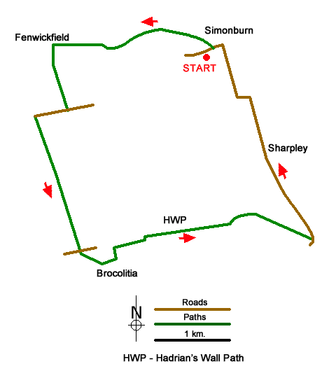
A circular walk from Simonburn exploring the pleasant rural countryside to the south of the village. The route includes a section of Hadrian's Wall from Brocolitia to an un-excavated Roman Camp just east of milecastle 30. The walk includes a section of the Hadrian's Wall Path and some well-preserved sections of the wall.
The start is the car park opposite St Mungo's Church in Simonburn (grid ref. NY871736). Exit the car park and turn right to the village green. Turn left along Castle Lane, continue past a row of cottages on your left, then fork left by the notice board on a tree. Continue along the lane for 600 metres to the edge of woodland. Cross the small bridge and continue ahead on a track (signed Fenwickfield). Continue along the track to exit the trees and reach Fenwickfield Farm (grid ref. NY853736).
Turn left (not signed) on a bridleway, aiming for the far corner of the plantation on your right. Cross a stream and stile and maintain direction on the left-hand side of a strip of woodland. Exit to a lane near Greehhaugh. Turn left and continue to the end of the lane (grid ref. NY851728). Turn right over stile by fingerpost and maintain direction down an enclosed track for 1.5 kilometres to reach the B6318. Cross the road and take ladder stile opposite and continue along the Hadrian's Wall Path to Bricoliltia and Mithraeum (Temple of Mithras).
From Bricolitia the path returns towards the road to exit onto the road at a wall stile. Turn left along the road and almost immediately right down a track. Turn right over the stile and continue along the Hadrian's Wall Path which runs parallel to the road. The view to your left is across the North Tyne Valley with the Cheviot Hills in the distance. As you make progress there is more evidence of the defensive earthworks and some sections of the wall.
Reaching a lane (grid ref. NY883713), turn left and continue along this quiet by-way to pass Sharpley Farm on your right. Continue walking north for 750 metres and follow the lane as it bends left to a junction (grid ref. NY875730). Turn right and follow this lane back passing Hall Barns on your left into Simonburn. Cross the river bridge and bear left back to the start.
Messaging & Social Media
Message Walking Britain and follow the latest news.

Mountain Weather
Stay safe on the mountains with detailed weather forecasts - for iOS devices or for Android devices.