Walk 1797 - printer friendly version
Morthoe, Morte Point & Bull Point circular Walk
Author - Lou Johnson
Length - 6.0 miles / 9.8 km
Ascent - 1200 feet / 364 metres
Grade - easy/mod
Start - OS grid reference SS457452
Lat 51.1851450 + Long -4.2091890
Postcode EX34 7DR (approx. location only)
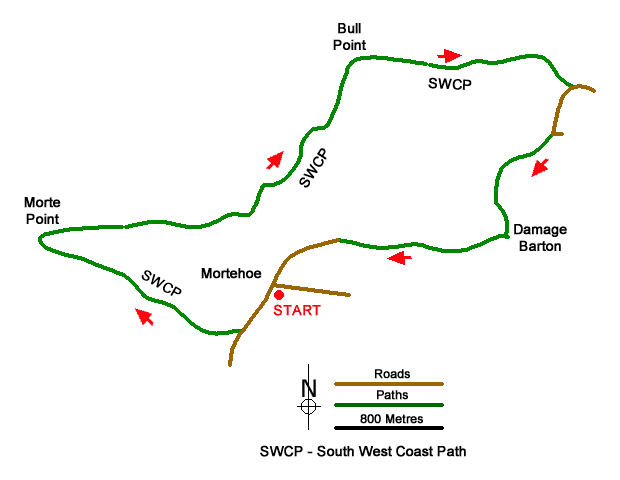
An energetic coastal walk from Mortehoe offering excellent views along the coast, to the Island of Lundy and across the Bristol Channel to Wales. The route follows the South West Coast Path for a section of the walk with the section between Lee Bay and Woolacombe one of the most dramatic coastal sections in North Devon with many shipwrecks recorded over the years. It is worth noting that the walk includes three steep ascents, but these are more than compensated for by the unique geology and wonderful views.
The start is the car park in Mortehoe (grid ref. SS457452). Exit the car park and turn left past the post office on your right. Bear left with St Mary Church on your right. Continue downhill out of the village and turn right onto the signed footpath (Cost Path - Morte Point). Continue on the path which descends across the hillside to reach the South West Coast Path above Grunta Beach (grid ref. SS454450). Bear right and continue along the clear undulating path to reach Morte Point.
From here the path turns east and after a steep descent passes above Rockham Beach. A short steep climb follows with the path undulating along the cliff tops to reach Bull Point with its lighthouse. Another steep descent and ascent follow before passing Damagehue Rock before descending steps to reach a lane (grid ref. SS467465). Turn right up the lane and continue up the lane to where the lane bends sharp left. At this point continue ahead on the grassy track (signed footpath) After 400 metres continue ahead as a track comes in on your right.
Continue ahead through the farm at Damage Barton to join their access road. Just after the point where the road bends left, turn left onto a signed footpath. The path follows the right-hand side of two fields to join a track between hedges (grid ref. SS468455). The follow the signed footpath through a campsite to exit onto North Morte Road. Bear left and follow this road into Mortehoe and the car park used at the start.
Messaging & Social Media
Message Walking Britain and follow the latest news.

Mountain Weather
Stay safe on the mountains with detailed weather forecasts - for iOS devices or for Android devices.