Morthoe, Morte Point & Bull Point circular
Devon Walk
County/Area - Devon
Author - Lou Johnson
Length - 6.0 miles / 9.8 km Ascent - 1200 feet / 364 metres
Time - 4 hours 10 minutes Grade - easy/mod
Walk Route Description
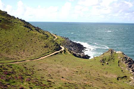
Click image to see photo description.
An energetic coastal walk from Mortehoe offering excellent views along the coast, to the Island of Lundy and across the Bristol Channel to Wales. The route follows the South West Coast Path for a section of the walk with the section between Lee Bay and Woolacombe one of the most dramatic coastal sections in North Devon with many shipwrecks recorded over the years. It is worth noting that the walk includes three steep ascents, but these are more than compensated for by the unique geology and wonderful views.
The start is the car park in Mortehoe (grid ref. SS457452). Exit the car park and turn left past the post office on your right. Bear left with St Mary Church on your right. Continue downhill out of the village and turn right onto the signed footpath (Cost Path - Morte Point). Continue on the path which descends across the hillside to reach the South West Coast Path above Grunta Beach (grid ref. SS454450). Bear right and continue along the clear undulating path to reach Morte Point.
From here the path turns east and after a steep descent passes above Rockham Beach. A short steep climb follows with the path undulating along the cliff tops to reach Bull Point with its lighthouse. Another steep descent and ascent follow before passing Damagehue Rock before descending steps to reach a lane (grid ref. SS467465). Turn right up the lane and continue up the lane to where the lane bends sharp left. At this point continue ahead on the grassy track (signed footpath) After 400 metres continue ahead as a track comes in on your right.
Continue ahead through the farm at Damage Barton to join their access road. Just after the point where the road bends left, turn left onto a signed footpath. The path follows the right-hand side of two fields to join a track between hedges (grid ref. SS468455). The follow the signed footpath through a campsite to exit onto North Morte Road. Bear left and follow this road into Mortehoe and the car park used at the start.
Maps 

| Ordnance Survey Explorer 137 | Sheet Map | 1:25k | BUY |
| Anquet OS Explorer 137 | Digital Map | 1:25k | BUY |
| Ordnance Survey Digital Map Subscription | |||
| Latest Ordnance Survey Discounts | |||
Other walks nearby
| Walk 2028 | Croyde to Baggy Point Circular | easy | 5.5 miles |
| Walk 3393 | Great Hangman Hill | easy/mod | 4.3 miles |
| Walk 2161 | Appledore to Westward Ho! | easy | 4.5 miles |
| Walk 1047 | Abbotsham Cliff beach and Kipling's Tor, Westward Ho! | easy | 3.5 miles |
| Walk 3394 | Holdstone Down & Trentishoe | moderate | 7.0 miles |
| Walk 3749 | Codden Hill Circular | easy/mod | 4.8 miles |
| Walk 3390 | Heddon Valley from Woody Bay | moderate | 5.3 miles |
| Walk 2295 | Buck's Mill & Peppercombe | easy/mod | 6.2 miles |
| Walk 1719 | Clovelly & the South West Coast Path | easy/mod | 6.0 miles |
| Walk 3391 | Valley of Rocks frrom Lynton | easy/mod | 3.8 miles |
Recommended Books & eBooks
The South West Coast Path
 Guidebook to walking the entire South West Coast Path National Trail. The route runs for 630 miles from Minehead to Poole along the north Devon, Cornish, south Devon and Dorset coastline. Divided into 45 stages, this long-distance coastal trek could be completed within 4 weeks, or walked in sections. Guide includes maps and essential information.
More information
South West Coast Path Map Booklet - St Ives to Plymouth
 Map of part of the southern section of the 630 mile (1014km) South West Coast Path National Trail. Covers the trail from St Ives to Plymouth along the west Cornwall and Devon coastline. This convenient and compact booklet of Ordnance Survey 1:25,000 maps shows the route, providing all of the mapping you need to walk the trail in either direction.
More information
