Saltburn and Skelton from Skinningrove
Redcar and Cleveland Walk
County/Area - Redcar and Cleveland
Author - Andy Chaplin
Length - 10.4 miles / 16.9 km Ascent - 1200 feet / 364 metres
Time - 6 hours 20 minutes Grade - moderate
Walk Route Description
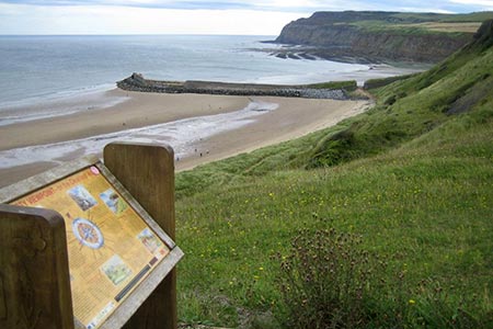
Click image to visit gallery of 4 images.
This Redcar and Cleveland circular walk is based on part of the Cleveland Way. There are some pleasant coastal sections and the walk into Saltburn from the cliff tops and out again through the Skelton valley park is interesting. For fans of old mines, you also pass close to the Lumpsey Ironstone mine.
The walk starts at the parking area at the sea front to the west of the Kelton beck in Skinningrove (grid ref. NZ712201). Follow the Cleveland Way path along the sea front to the jetty. When you pass the jetty take the path just above the beach in the dunes. There are several sets of steps up the bank to the cliff top where there is an information board describing points of interest along the nearby coast. A little further on you will pass the remains of the Huntcliffe fan house where there is another information board.
Follow the Cleveland Way along Cattersty cliffs and Hunt cliff then down into Saltburn. There are good views all the way to the Tees estuary although maybe sea-based windmills are an acquired taste? The seafront is a good place to rest awhile before climbing up Saltburn Bank to Glenside. Shortly after passing the bandstand the CW is signed off to the left through Skelton Valley Park.
After just under a mile you pass under the railway viaduct then climb out of the Skelton beck valley and come up to an underpass below the A174 and then into Skelton. Here is a bit of boring urban walking through Skelton although still on the Cleveland Way. Then at grid ref. NZ656185 after passing a viewpoint overlooking Skelton, with another information board, and as you are heading across country to Skelton Green, take the byway off on the left towards Trout Hall Lane.
Go left on Trout Hall Lane past Trout Hall then right on Stanghow Road until you cross White Cross beck and the Cleveland Street route is signed off on the left. All of the next part of the route is both Cleveland Street and part of the Ironstone Heritage Trail. The path comes into North Skelton (why North?) then follows the road eastwards under the railway bridge. From here it goes off right across fields to cross the railway once more near the site of the old Lumpsey Ironstone Mine. Cleveland Ironstone mining is well worth a Google. After looking at the remains of the mine head east. It is quite confusing at this point as it is a junction of tracks and old railway lines. There are no way-mark signs until you have got onto the right path so just check that you are heading east. The route carries on eastwards to Carlin How past Craggs Hall farm. The steel works is clearly visible as you head back towards Skinningrove. Cross over the A174 onto Wesley Terrace then take the path off on the right and follow it down to Mill Lane then along to the sea front.
Maps 

| Ordnance Survey Explorer Ol26 | Sheet Map | 1:25k | BUY |
| Anquet OS Explorer Ol26 | Digital Map | 1:25k | BUY |
| Ordnance Survey Explorer 306 | Sheet Map | 1:25k | BUY |
| Anquet OS Explorer 306 | Digital Map | 1:25k | BUY |
| Ordnance Survey Digital Map Subscription | |||
| Latest Ordnance Survey Discounts | |||
Other walks nearby
| Walk 2090 | Easington Beck & Staithes from Loftus | moderate | 11.5 miles |
| Walk 2174 | Warsett Hill from Saltburn-by-the-Sea | easy | 4.3 miles |
| Walk 1476 | Boulby Mine to Whitby by the Cleveland Way | moderate | 12.5 miles |
| Walk 1050 | Highcliff Nab & Roseberry Topping from Slapewath | moderate | 10.5 miles |
| Walk 1452 | Leaholm Moor & Scaling Dam | moderate | 9.8 miles |
| Walk 3532 | Runswick Bay to Staithes | easy | 3.8 miles |
| Walk 1887 | Runswick Bay & Kettleness | moderate | 9.0 miles |
| Walk 2685 | Highcliff Nab and Guisborough Moor | moderate | 11.1 miles |
| Walk 3737 | Commondale & Esk Valley | easy/mod | 8.2 miles |
| Walk 1450 | Little & Great Fryup Dales | moderate | 8.3 miles |
