Walk 1857 - printer friendly version
Start Point & East Prawle Walk
Author - Lou Johnson
Length - 8.2 miles / 13.3 km
Ascent - 1300 feet / 394 metres
Grade - moderate
Start - OS grid reference SX821375
Lat 50.2257200 + Long -3.6541993
Postcode TQ7 2ET (approx. location only)
This walk from Start Point explores a beautiful section of the South West Coast Path along which there are few signs of habitation. The route traverses the length of Lannacombe Bay before turning in land to the village of East Prawle where refreshments are available at the Pigs Nose pub. The walk then turns inland across farmland before re-joining the coast path back to the start.
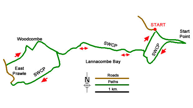
The walk begins from Start Point car park (grid ref. SX821375). Before starting the walk check the information board which details the highlights of the extensive view across Start Bay. To continue, pass through the small gate and follow the South West Coast Path past another information board to reach a path junction where the SWCP goes right (grid ref. SX824372). From here continue down to Start Point lighthouse.
Return up the track from the lighthouse and turn left onto the South West Coast Path. At the junction detailed in the first paragraph. The undulating path, with many twists and turns, continues past Great Sleaden Rock and on to a path junction with fingerpost (grid ref. SX818370), which will be used to return to the car park at the end of the walk. Continue above Mattiscombe Sands to reach a small parking area at Lannacombe Beach (grid ref. SX802372). Continue past Maelcombe House on your right and after 400 metres bear right at a path junction with fingerpost (East Prawle) to leave the coast path.
The path climbs and soon joins a track enclosed by hedges. Follow the track which bends right. At the next junction turn right (grid ref. SX783359) and follow the to a tarmac lane. Bear right uphill into East Prawle village centre and green. Turn right beside the Piglet Café and continue down to the Pig Nose pub. Turn right and then go left at the next junction Take the next lane on the right (before a bungalow) and continue up the lane to reach a small green and junction with a telephone box ahead.
At the end of the tarmac continue ahead on an initially enclosed track for 600 metres to reach a junction (grid ref. SX787371) just before reaching Woodcombe Farm. Turn right along a clear track and follow it round a left-hand bend. After 150 metres the main tracks bends right. Continue ahead here between hedges. Where the tracks forks after 150m metres, veer right and follow the path down to reach the coast path (grid ref. SX795369).
Turn left along the coast path and retrace your steps back to the fingerpost (grid ref. SX818370) where you turn left and follow the path back to the car park.
Messaging & Social Media
Message Walking Britain and follow the latest news.

Mountain Weather
Stay safe on the mountains with detailed weather forecasts - for iOS devices or for Android devices.