Start Point & East Prawle
Devon Walk
County/Area - Devon
Author - Lou Johnson
Length - 8.2 miles / 13.3 km Ascent - 1300 feet / 394 metres
Time - 5 hours 20 minutes Grade - moderate
Walk Route Description
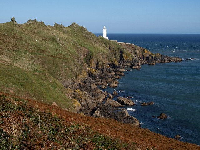
Click image to see photo description.
This walk from Start Point explores a beautiful section of the South West Coast Path along which there are few signs of habitation. The route traverses the length of Lannacombe Bay before turning in land to the village of East Prawle where refreshments are available at the Pigs Nose pub. The walk then turns inland across farmland before re-joining the coast path back to the start.
The walk begins from Start Point car park (grid ref. SX821375). Before starting the walk check the information board which details the highlights of the extensive view across Start Bay. To continue, pass through the small gate and follow the South West Coast Path past another information board to reach a path junction where the SWCP goes right (grid ref. SX824372). From here continue down to Start Point lighthouse.
Return up the track from the lighthouse and turn left onto the South West Coast Path. At the junction detailed in the first paragraph. The undulating path, with many twists and turns, continues past Great Sleaden Rock and on to a path junction with fingerpost (grid ref. SX818370), which will be used to return to the car park at the end of the walk. Continue above Mattiscombe Sands to reach a small parking area at Lannacombe Beach (grid ref. SX802372). Continue past Maelcombe House on your right and after 400 metres bear right at a path junction with fingerpost (East Prawle) to leave the coast path.
The path climbs and soon joins a track enclosed by hedges. Follow the track which bends right. At the next junction turn right (grid ref. SX783359) and follow the to a tarmac lane. Bear right uphill into East Prawle village centre and green. Turn right beside the Piglet Café and continue down to the Pig Nose pub. Turn right and then go left at the next junction Take the next lane on the right (before a bungalow) and continue up the lane to reach a small green and junction with a telephone box ahead.
At the end of the tarmac continue ahead on an initially enclosed track for 600 metres to reach a junction (grid ref. SX787371) just before reaching Woodcombe Farm. Turn right along a clear track and follow it round a left-hand bend. After 150 metres the main tracks bends right. Continue ahead here between hedges. Where the tracks forks after 150m metres, veer right and follow the path down to reach the coast path (grid ref. SX795369).
Turn left along the coast path and retrace your steps back to the fingerpost (grid ref. SX818370) where you turn left and follow the path back to the car park.
Maps 

| Ordnance Survey Explorer OL20 | Sheet Map | 1:25k | BUY |
| Anquet OS Explorer OL20 | Digital Map | 1:25k | BUY |
| Ordnance Survey Digital Map Subscription | |||
| Latest Ordnance Survey Discounts | |||
Other walks nearby
| Walk 3431 | Beeson to Salcombe | mod/hard | 12.0 miles |
| Walk 1866 | East Prawle & Prawle Point | easy/mod | 4.1 miles |
| Walk 2474 | East Prawle Coast Circular | easy/mod | 5.6 miles |
| Walk 3427 | Slapton Sands & Stokenham | easy/mod | 8.0 miles |
| Walk 3346 | Start Point from Torcross | easy/mod | 8.0 miles |
| Walk 3432 | Salcombe to Thurlestone | mod/hard | 11.0 miles |
| Walk 2371 | Kingswear to Brixham | moderate | 10.8 miles |
| Walk 3587 | Kingswear from Coleton Fishacre | moderate | 7.0 miles |
| Walk 2461 | Warren Point & Bolt Tail from Bantham | moderate | 9.0 miles |
| Walk 3041 | Thurlestone circular | easy | 4.0 miles |
Recommended Books & eBooks
South West Coast Path Map Booklet - St Ives to Plymouth
 Map of part of the southern section of the 630 mile (1014km) South West Coast Path National Trail. Covers the trail from St Ives to Plymouth along the west Cornwall and Devon coastline. This convenient and compact booklet of Ordnance Survey 1:25,000 maps shows the route, providing all of the mapping you need to walk the trail in either direction.
More information
The South West Coast Path
 Guidebook to walking the entire South West Coast Path National Trail. The route runs for 630 miles from Minehead to Poole along the north Devon, Cornish, south Devon and Dorset coastline. Divided into 45 stages, this long-distance coastal trek could be completed within 4 weeks, or walked in sections. Guide includes maps and essential information.
More information
