Walk 1887 - printer friendly version
Runswick Bay & Kettleness Walk
Author - Lou Johnson
Length - 9.0 miles / 14.6 km
Ascent - 1300 feet / 394 metres
Grade - moderate
Start - OS grid reference NZ807161
Lat 54.533754 + Long -0.7543790
Postcode TS13 5JF (approx. location only)
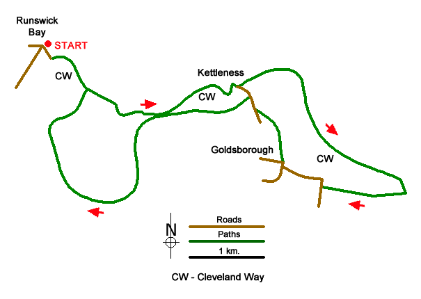
This walk from Runswick Bay, in the North York Moors National Park, combines a costal section of the Cleveland Way with an inland section following the disused track-bed of the railway between Saltburn and Whitby. The route follows well signed paths and tracks and should present no navigational difficulties.
The walk starts from the cliff-top pay and display car park at Runswick Bay (grid ref. NZ807161). An alternative car park is at Bank Bottom behind the beach (grid ref. NZ809160). From the top car park walk to the exit and turn right onto the Cleveland passing between wooden posts. Follow the path as it loops down to Ban Bottom. Turn left towards the beach passing the alternative car park on your right. Descend to a black and yellow barrier and bear right onto a path which soon drops down to the beach. Continue along the beach for 600 metres to reach a cleft in the cliffs (grid ref. 815154). Turn right and follow the path uphill with some sections stepped.
After a steady climb you reach the cliff top and pass a welcome seat if you need a rest. After just over a kilometre of easy walking on an often grassy path, the path turns inland beside a deep valley before swinging left to enter Kettleness (grid ref. NZ829156). Keep to the left of a stone barn to regain the cliff-top path. After two kilometres of pleasant walking, you reach a three-way fingerpost (grid ref. NZ850145). Turn right signed to Lythe.
Turn inland along the path for just under 200 metres and turn right. Continue along the right-hand side of two fields to join the access track to Overdale Farm. Continue ahead along the track to join Golsborough Lane. Turn right, follow the lane around to the left and continue ahead into the village of Goldsborough. Pass a phone box on your left, continue straight across the next junction. 80 metres the junction, turn right onto a signed path (grid ref. NZ835147). Keep to the left of the buildings to enter a large field. Walk half left across this field. Enter the second field and aim to the immediate right of a small stone barn to join a lane (grid ref. NZ833154).
Turn right along the lane and after 200 metres turn left onto the former railway. Continue along the clear path for four kilometres to Low House (grid ref. NZ807151). Turn right down Cloverdale Lane. Initially a track it soon becomes a path which descends to the beach. Turn left and retrace your route back to Runswick Bay where the village is worth exploring. Note If you have parked at the cliff top car park you can continue ahead along the old railway at Low House. Reaching a road, turn right back to the start.
Messaging & Social Media
Message Walking Britain and follow the latest news.

Mountain Weather
Stay safe on the mountains with detailed weather forecasts - for iOS devices or for Android devices.