Loch Turret to Comrie
Perth and Kinross Walk
County/Area - Perth and Kinross
Author - Drovers' Tryst Team
Length - 8.0 miles / 13 km Ascent - 920 feet / 279 metres
Time - 5 hours 0 minutes Grade - easy/mod
Walk Route Description
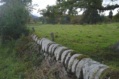
Click image to see photo description.
A beautiful walk through the hills on the north side of Strathearn, passing lonely Braefordie and involving a visit to the remains of an ancient stone circle.
This walk involves some transport logistics, but it is well worth it. Either start by walking to Turret Dam, Grid Ref NN821265, from Crieff, or park a car there. The walks starts by crossing the dam wall, with great views north across Loch Turret to Auchnafree Hill. Cross the stile, and bear left, following the landrover track south along the edge of the forest. The track turns left, gently ascending across open moorland. At its highest point, there are fantastic views towards Ben Vorlich, Stuic a’ Chroin and other hills to the west.
Continuing along the track, you will see a recently(?) abandoned farmhouse, Braefordie, which sets the imagination on fire as to why it is no longer inhabited and what it would be like to live in such a remote location. Leave the main track and turn left, briefly following a track which leads south down to the house. However, your journey is taking you west, so after about 20m, turn off the track, following a faint sheep path which wends and weaves its way through grass and bracken. At times the path is damp underfoot, and at one point, you will have to clamber over a low gate, but eventually, though a gap in a dry-stone wall, you will join an obvious landrover track again.
At Grid Ref NN785250, you may wish to take a short detour, turning off the path, up a short, sharp ascent, to the summit of a small hill, where you will find the remains of a pre-historic stone circle. Thousands of years ago, on this lonely spot, six large stones clearly were put together to form a group, although only one of them now remains standing. There are wonderful panoramic views down to Comrie and the Baird Monument, up to Glen Lednock and to the larger hills in the distance. From the stone circle, retrace your steps, returning to the track below, and continuing west. After a short distance, at the edge of the woodland, turn left off the main path, go through a gate, and follow an obvious grassy footpath on the other side, south, to Comrie. The path trends gently downhill, past a couple of sheep pens. As the path approaches a woodland, it curves east, at which point, you will turn off onto a less obvious path which runs parallel to a dry-stone wall on your right, through a short section of bracken & gorse to a gate. Go through the gate (passing by the skeleton of a sheep!) and at once, you will be on a wide grassy track, enveloped in a cool, shady and silent pine forest. The trees form a high canopy overhead. This last section of the walk has a completely different atmosphere from the moorland you've now left behind.
Follow the path through the woods to a T-junction, and then turn right, heading steeply downhill. At the bottom, follow the path over a small stone bridge, crossing the burn, and then gently uphill until you finally join the Milton Road, a Forestry Commission track which drops down to the A85 outside Comrie. A short detour up a wide grassy path on the left will lead to a lonely walled graveyard surrounded by yew trees. This is the family burial ground of the McLagan family. Further below on the Milton Road, there are paths off to the right in the woods leading to the Comrie Golf Course, which can be circuited to get into Comrie itself.
There are buses back to Crieff, and then a hefty walk back up to the Turret Dam to collect your car - or perhaps you have made arrangements with a friend prior to the walk to have a car waiting at Comrie.
Maps 

| Ordnance Survey Explorer OL47 | Sheet Map | 1:25k | BUY |
| Anquet OS Explorer OL47 | Digital Map | 1:25k | BUY |
| Ordnance Survey Digital Map Subscription | |||
| Latest Ordnance Survey Discounts | |||
Other walks nearby
| Walk 3747 | Ben Chonzie from Loch Turret | mod/hard | 10.0 miles |
| Walk 2185 | Ben Vorlich from Loch Earn | moderate | 6.0 miles |
| Walk 1352 | Tarmachan Ridge | mod/hard | 9.4 miles |
| Walk 3067 | Beinn Ghlas & Ben Lawers from near Killin | mod/hard | 6.5 miles |
| Walk 1054 | Beinn Ghlas and Ben Lawers from near Loch Tay | mod/hard | 6.5 miles |
| Walk 3647 | Callander, Samson's Stone & Coilhallan Wood | easy | 4.7 miles |
| Walk 1350 | Ben Ledi from near Falls of Leny | moderate | 5.5 miles |
| Walk 2709 | Dumyat Hill | easy/mod | 4.5 miles |
| Walk 1046 | Schiehallion via main path | moderate | 6.4 miles |
| Walk 2222 | Ben Cleuch from Tillicoultry | moderate | 7.0 miles |
