Dumyat Hill from Blairlogie
Stirling Walk
County/Area - Stirling & Clackmannanshire
Author - Lou Johnson
Length - 4.5 miles / 7.3 km Ascent - 1400 feet / 424 metres
Time - 3 hours 40 minutes Grade - easy/mod
Walk Route Description
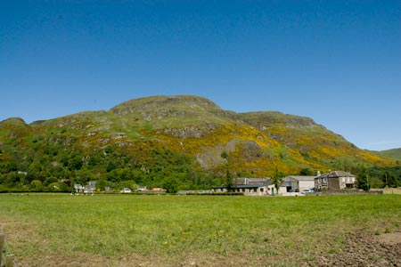
Click image to visit gallery of 12 images.
The Ochills lie to the east of Stirling and are noted for the wonderful crags on the southern face of the hills. This walk tackles one of the most shapely summits, which due to its accessibility is often quite busy with walkers. This route starts from the small car park (grid ref. NS831968) on the north side of A91 just east of Blairlogie and follows a circular route over the hill.
After parking exit the car park through the gap in the hedge and turn left onto the path. When the path splits bear right and start to climb up through trees following a small stream initially on your left but as you gain height on your left. Ahead you can now see the open hillside with a clear path slanting across the grass. Take this path climbing quickly to reach a junction of paths (grid ref. NS822974). Turn sharp right and continue to climb to another path junction (grid ref. NS824976). Bear right on to the main path to the summit.
The path is quite eroded in places and the temptation is to storm ahead and ignore the view. However there is much to be seen including Stirling Castle and the Wallace Monument to the south west with the Campsie Fells in the distance. Looking northwest you have wide arc of higher hills in the Loch Lomond and Trossachs area. Turning southeast you can see across the River Forth to Edinburgh and the Pentland Hills. Not a bad view for a small hill!
The summit of Dumyat Hill (418m) is soon reached and you can enjoy a 360 degree panorama, which now includes views across more of the Ochills. The summit area is littered with construction including a concrete trig point, a stone filled beacon and a regimental badge.
After enjoying the view descend east from the summit initially over steep grassy slopes. The start of this path is not too obvious and you need to go about 10 metres from the trig point to locate it. Once found the path zigzags down the steep slope gradually levelling off and leading down to reach a stony track (grid ref. NS845976).
Turn right on this track. This descends turning west to pass some cottages. On your right are the impressive crags that form the south face of Dumyat. Stay on the track to reach a cattle grid. Do not cross the grid, instead take the path on the left. Cross a small footbridge and continue back to the car park, which is reached after about 500 metres.
Maps 

| Ordnance Survey Explorer 366 | Sheet Map | 1:25k | BUY |
| Anquet OS Explorer 366 | Digital Map | 1:25k | BUY |
| Ordnance Survey Digital Map Subscription | |||
| Latest Ordnance Survey Discounts | |||
Other walks nearby
| Walk 2222 | Ben Cleuch from Tillicoultry | moderate | 7.0 miles |
| Walk 1557 | The Falkirk Wheel and the Kelpies | easy/mod | 8.0 miles |
| Walk 1979 | Culross Heritage | easy | 1.5 miles |
| Walk 2439 | Forth & Clyde Canal & Antonine Wall | easy | 6.0 miles |
| Walk 3647 | Callander, Samson's Stone & Coilhallan Wood | easy | 4.7 miles |
| Walk 1350 | Ben Ledi from near Falls of Leny | moderate | 5.5 miles |
| Walk 3747 | Ben Chonzie from Loch Turret | mod/hard | 10.0 miles |
| Walk 1968 | Loch Turret to Comrie | easy/mod | 8.0 miles |
| Walk 2185 | Ben Vorlich from Loch Earn | moderate | 6.0 miles |
| Walk 2309 | Ben A'an from Loch Achray | easy/mod | 2.5 miles |
