Lasborough & Ozleworth Bottom
Cotswolds Walk
Region - Cotswolds
County/Area - Gloucestershire
Author - Lou Johnson
Length - 5.8 miles / 9.4 km Ascent - 700 feet / 212 metres
Time - 3 hours 40 minutes Grade - easy/mod
Walk Route Description
Click image to see photo description.
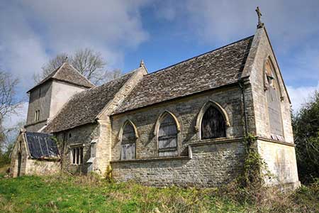
A delightful Cotswolds walk from near Kingscote. The interesting route includes open countryside, woodland, small lakes, excellent views, and an abandoned church. Following paths, bridleways and a short section along a quiet country lane, the walk offers a taste of the Cotswolds.
The start is Hunter's Hall Inn on the A4135 a few miles east of Dursley (grid ref. ST814960). After parking face the A4135 and turn right. Take the first footpath on the right through a kissing gate and walk half left across the field. Reaching the corner of Furze Grove bear right alongside the woodland and once through the trees curve left along a grassy track and take the path on the right into a small wood (grid ref. ST813953). Follow the path through the trees with a valley on your left. Continue along the path to reach a lane.
Turn left along the lane soon passing the abandoned church of St. Bartholomew on your right. Just past the church, take the first footpath on the right. The path initially follows the right-hand side of a field before turning left to follow a wall. Entering a second field there is a three-way path junction. Take the right-hand path keeping to the right of a large group of trees. Down to your left is Lasborough with its church, manor, and park. Continue south to a solitary tress and then cross a drive (grid ref. ST819939). Continue through a gate and descend into a broad valley. Pass through trees, keep to the left of a small lake, and enter woodland.
The path continues along the valley floor with a small stream on your left into Ozleworth Bottom. Two kilometres beyond the small lake you reach a junction of paths (grid ref. ST798929). Turn right onto a rising bridleway into a wood. Ignore a track coming in from the right, and a track on the left. At the next junction turn right and go straight across a track following a clear rising track (grid ref. ST801933). Follow this track for about 800 metres to join Scrubbett's Lane.
Turn left and continue for just under a kilometre to take the first signed footpath on the right (grid ref. ST807949). Keep to the right-0hand edge of the field for a few metres and then turn left across the field to a lane (with fingerpost). Cross the lane into the field opposite. Keep to the left-hand side of the field. After 180 metres bear half-right across the field and enter the next field where you re-join the outward route. Either follow the path used at the start of the walk or fork left onto the path through woodland back to the start.
Maps 

| Ordnance Survey Explorer 168 | Sheet Map | 1:25k | BUY |
| Anquet OS Explorer 168 | Digital Map | 1:25k | BUY |
| Ordnance Survey Digital Map Subscription | |||
| Latest Ordnance Survey Discounts | |||
Other walks nearby
| Walk 1877 | Uley Bury & Cam Long Down | easy/mod | 5.5 miles |
| Walk 1258 | The Tyndale Monument | easy/mod | 5.5 miles |
| Walk 1337 | Westonbirt Arboretum | moderate | 10.0 miles |
| Walk 2753 | Tetbury Circular | easy | 4.5 miles |
| Walk 2147 | Arlington Peninsula from Saul Junction | easy/mod | 6.2 miles |
| Walk 2674 | Source of the River Thames | moderate | 11.3 miles |
| Walk 3663 | Sudgrove & Edgeworth from Miserden | easy/mod | 6.0 miles |
| Walk 3750 | River Severn from Arlingham | easy | 6.0 miles |
| Walk 3347 | Ford & North Wraxall from Castle Combe | easy/mod | 8.0 miles |
| Walk 2698 | Castle Combe Circular | easy | 5.0 miles |
Recommended Books & eBooks
The Cotswold Way Map Booklet
 Map of the 102 mile (163km) Cotswold Way National Trail, between Chipping Camden and Bath. This booklet is included with the Cicerone guidebook to the trail, and shows the full route on OS 1:25,000 maps. The trail typically takes two weeks to walk, and is suitable for walkers at all levels of experience.
More information
The Cotswold Way
 Guidebook to walking the Cotswold Way National Trail. Between Chipping Campden and Bath, the 102 mile route explores the Cotswolds AONB. Described in both directions over 13 stages, the Cotswold Way can be walked year round and is suitable for beginner trekkers. Includes separate OS 1:25,000 map booklet of the route.
More information
