Ravenglass & the Esk Estuary
Cumbria Walk
County/Area - Cumbria - West Cumbria
Author - Lou Johnson
Length - 3.4 miles / 5.5 km Ascent - 250 feet / 76 metres
Time - 2 hours 0 minutes Grade - easy
Walk Route Description
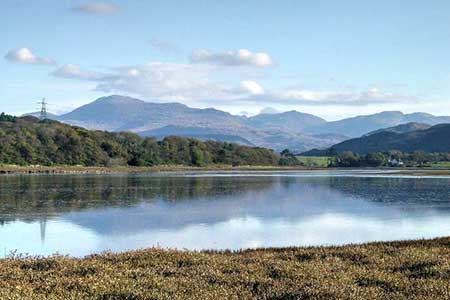
Click image to see photo description.
A short circular walk from Ravenglass on the West Cumbria coast. The route turns south following inland paths passing Roman ruins along the way to reach Newtown Knott. From here there are good views along the coast and across the Esk Estuary. The walk then continues to the shores of the Esk Estuary which are followed west past Eskmeals Viaduct. The last section of the route follows the sandy shore back to the start. It is important to note that this part of the route is subject to tides, which should be checked before starting the walk.
The start is the large pay and display car park in Ravenglass (grid ref. SD085964). After parking walk to the south end of the car park and turn right on an enclosed path that leads to a bridge over the railway. Reaching a lane with adjacent fingerpost, turn right and follow the path south. Continue past the Roman bath house (on your left). Continue for 120 metres and take the left fork signed Newtown Knott View (grid ref. SD089958). Continue south along the track and climb gently across the western flank of Newtown Knott. If you wish you can divert left off the main route to enjoy a better view from the summit.
Continue south with a wall on your tight. Where the main track veers left, bear right and head down to a gap in a wall. The path descends steeply across a field to enter a plantation. Reaching a track, turn left and soon after right to exit the trees to the shores of the Esk Estuary (grid ref. SD098950). Turn right along the shore of the estuary. Ahead is Eskmeals Viaduct which crosses the River Esk. Pass under the railway and follow the shore north. (Note this section is subject to tides). Continue along the beach to join Main Street in Ravenglass. A right turn along an alley takes you back to the car park.
Maps 

| Ordnance Survey Explorer OL6 | Sheet Map | 1:25k | BUY |
| Anquet OS Explorer OL6 | Digital Map | 1:25k | BUY |
| Ordnance Survey Digital Map Subscription | |||
| Latest Ordnance Survey Discounts | |||
Other walks nearby
| Walk 1668 | Silver Knott & Muncaster Fell from Irton Road | easy/mod | 5.0 miles |
| Walk 2271 | Black Combe from near Stoneside Hill | easy/mod | 6.3 miles |
| Walk 2355 | Blea Tarn & Eskdale Green | easy/mod | 6.5 miles |
| Walk 3485 | High Birkhow & Low Wood from Wast Water | easy | 4.2 miles |
| Walk 1303 | Buckbarrow, Seatallan & Middle Fell from Loweswater | moderate | 7.0 miles |
| Walk 3489 | Scale Bridge & Low Wood from Greendale | easy | 5.2 miles |
| Walk 1301 | Great Stickle & Stickle Pike | moderate | 5.0 miles |
| Walk 1299 | Green Crag | moderate | 6.5 miles |
| Walk 2361 | Scafell & Slight Side | hard | 9.5 miles |
| Walk 2362 | Scafell Pike and Scafell | very hard | 11.0 miles |
Recommended Books & eBooks
Walking the Lake District Fells - Buttermere
 Part of the Walking the Lake District Fells series, this guidebook covers a wide range of routes to 32 Lakeland summits that can be climbed from the Buttermere, Lorton and Newlands valleys, with highlights including Haystacks, High Stile, Grasmoor and the fells of the Coledale Round. Suggestions for longer ridge routes are also included.
More information
Outdoor Adventures with Children - Lake District
 Guidebook to 40 outdoor adventures in the Lake District with children under 12, including walking, cycling, orienteering, paddling, boating, hostelling and more. Graded activities for varying age ranges or for families with children of different ages.
More information
