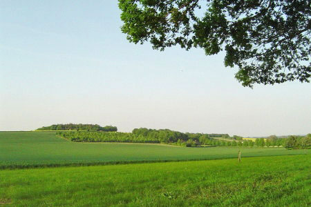
Watership Down and Ladle Hill from the Sydmonton Estate
North Wessex Downs Walk
Region - North Wessex Downs
County/Area - Hampshire
Author - Peter Lane
Length - 4.5 miles / 7.3 km Ascent - 500 feet / 152 metres
Time - 2 hours 50 minutes Grade - easy
Walk Route Description
Click image to visit gallery of 12 images.
A delightful short walk that features a fantastic section of the North Downs on the renowned Watership Down made famous by the eponymous novel about rabbits! The walk also features the incomplete iron age fort on Ladle hill and the genteel Sydmonton Estate. Views from the ridge (now forming part of the Wayfarer's Walk) are superb.
The walk commences near Wergs Farm, grid reference SU477582. Park on the side of the road, just before the farm if heading North towards Burghclere. Head North towards the farm and then after the farm buildings turn right along a broad track with superb views to the North up to Watership Farm. Take the first turn right down another broad track that passes paddocks, tree lined avenues and the impressive stately pile itself. Upon reaching the road through Sydmonton, turn left and after a few metres take a hedge-lined track that heads straight for the imposing Downs ahead. Ladle Hill is to the right, its fort hidden from view from below.
The track veers off left as it rises. Follow it as it turns into a tree lined lane with spectacular views into the valley below and Watership Down to the left. Upon reaching the crest, turn right onto the Wayfarer's Walk and follow it as it twists right then left towards the edge of a wood. At the end of the wood through a swing gate turn square left and follow the track as it turns square right passing a tumulus (ancient burial mound). The path climbs to the fenced off summit of Ladle Hill, an incomplete Iron Age Hill Fort. Explore this at your leisure and then return to the path.
At the end of the fort, the path turns left and descends slightly. The return route is marked with a waymarked post and a cairn. This bridlepath turns right at an acute angle, heading for the woods below. Enter the woods and follow the enclosed path all the way back to the start point. Note the view of Beacon Hill, highest point in Hampshire, by the A34 to the left.
Maps 

| Ordnance Survey Explorer 144 | Sheet Map | 1:25k | BUY |
| Anquet OS Explorer 144 | Digital Map | 1:25k | BUY |
| Ordnance Survey Digital Map Subscription | |||
| Latest Ordnance Survey Discounts | |||
Other walks nearby
| Walk 3594 | Beacon Hill near Burghclere | easy | 1.5 miles |
| Walk 3595 | Old Burghclere & Burghclere from Beacon Hill | easy/mod | 5.6 miles |
| Walk 3413 | North Wessex Downs & Source of the Test | moderate | 15.0 miles |
| Walk 1508 | Hannington & Kingsclere circular | easy | 6.0 miles |
| Walk 2114 | Hampshire and Berkshire Heights | moderate | 15.0 miles |
| Walk 2165 | Overton & the Harroway | easy | 4.3 miles |
| Walk 2344 | Newbury to Hungerford via Kennet & Avon Canal | easy/mod | 9.0 miles |
| Walk 1947 | Coombe Gibbet & Walbury Hill near Inkpen | easy/mod | 6.2 miles |
| Walk 2180 | Hamstead Park from Kintbury | easy/mod | 7.3 miles |
| Walk 1901 | Around Aldermaston | easy | 5.0 miles |
Recommended Books & eBooks
Walking Hampshire's Test Way
 Guidebook to walking the 71km (44 mile) Test Way in Hampshire from high on the chalk downs of Inkpen Beacon to the Eling Tide Mill near Southampton Water. Following the beautiful, crystal clear River Test, it passes picturesque villages and fascinating historic sites. Also includes 15 day walks to explore this lovely part of pastoral England.
More information
Walking in the North Wessex Downs
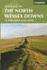 30 walking routes exploring the North Wessex Downs Area of Outstanding Natural Beauty (AONB). The routes are between 7km to 20km through this peaceful rolling chalk landscape covering parts of four counties: Berkshire, Hampshire, Wiltshire and Oxfordshire, with descriptions to reach the highest points in each one.
More information
