Beacon Hill near Burghclere
Hampshire Walk
County/Area - Hampshire
Author - Lou Johnson
Length - 1.5 miles / 2.4 km Ascent - 400 feet / 121 metres
Time - 1 hours 10 minutes Grade - easy
Walk Route Description
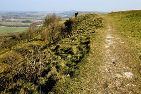
Click image to see photo description.
This short walk climbs Beacon Hill which is near the village of Burghclere and close to Watership Down, in north Hampshire. The hill was one of many Beacon Hills in England and beyond. Beacon Hill also has one of England's well-known hill forts on its slopes, which was constructed around 1000 BC. From the top of the hill there are some fine views which extend to much of Hampshire.
Access to the start is from the A34 following the brown signs for Beacon Hill. At the foot of the hill is a car park (grid ref. SU462577). To start the walk, exit the rear of the parking area and turn right through a gate. The path climbs, steeply in places, to reach the iron age embankments that form a circle on top of the hill. Of interest is the view to the north which includes Highclere Castle, where filming for the TV series Downtown was completed. After enjoying the view retrace your steps back to the start.
Note - If you want to spend more time on the hill and perhaps enjoy the view from a different perspective, then you can walk along the south ridge for about 500 metres before returning to the hill fort.
Maps 

| Ordnance Survey Explorer 144 | Sheet Map | 1:25k | BUY |
| Anquet OS Explorer 144 | Digital Map | 1:25k | BUY |
| Ordnance Survey Digital Map Subscription | |||
| Latest Ordnance Survey Discounts | |||
Other walks nearby
| Walk 2063 | Watership Down and Ladle Hill from the Sydmonton Estate | easy | 4.5 miles |
| Walk 2114 | Hampshire and Berkshire Heights | moderate | 15.0 miles |
| Walk 3413 | North Wessex Downs & Source of the Test | moderate | 15.0 miles |
| Walk 1508 | Hannington & Kingsclere circular | easy | 6.0 miles |
| Walk 2165 | Overton & the Harroway | easy | 4.3 miles |
| Walk 2344 | Newbury to Hungerford via Kennet & Avon Canal | easy/mod | 9.0 miles |
| Walk 1947 | Coombe Gibbet & Walbury Hill near Inkpen | easy/mod | 6.2 miles |
| Walk 2180 | Hamstead Park from Kintbury | easy/mod | 7.3 miles |
| Walk 3720 | Ham, Inkpen Hill & Lower Green Circular | easy/mod | 6.0 miles |
| Walk 1901 | Around Aldermaston | easy | 5.0 miles |
Recommended Books & eBooks
Walking Hampshire's Test Way
 Guidebook to walking the 71km (44 mile) Test Way in Hampshire from high on the chalk downs of Inkpen Beacon to the Eling Tide Mill near Southampton Water. Following the beautiful, crystal clear River Test, it passes picturesque villages and fascinating historic sites. Also includes 15 day walks to explore this lovely part of pastoral England.
More information
