Newbury to Hungerford via Kennet & Avon Canal
Berkshire Walk
County/Area - Berkshire
Author - Lou Johnson
Length - 9.0 miles / 14.6 km Ascent - 150 feet / 45 metres
Time - 4 hours 40 minutes Grade - easy/mod
Walk Route Description
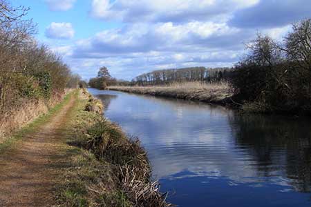
Click image to see photo description.
The Kennet and Avon Canal has a length of 87 miles and consists of two sections of navigable river linked by a canal. From Bristol to Bath the waterway follows the River Avon. Then a 57 mile-long canal section providing a link to the River Kennet at Newbury and on to Reading where the waterway continues along the River Thames. The canal was built between 1795 and 1810 but with the construction of railways it fell into disuse. The canal was subsequently restored in the 20th century including many locks and was reopened in 1990.
This linear walk follows the Kennet and Avon Canal westwards from Newbury to Hungerford and requires the use of two cars or rail travel between the start and end. It is probably best to park in Hungerford and take the regular train service to Newbury to start the walk. From Newbury railway station exit on the north side and bear right through the station forecourt to follow Cheap Street towards the river/canal. Turn left into Wharf Street passing the Tourist Information on your left and then right over the river/canal bridge and drop down to the towpath on the left.
The route needs little further explanation as you stay on the canal towpath all the way to Hungerford where the railway station is very close to canalside path. During the walk you will be able see many boats using the canal including traversing the locks passed on the way. To the north of the canal lies the River Kennet and its flood plain.
Maps 

| Ordnance Survey Explorer 158 | Sheet Map | 1:25k | BUY |
| Anquet OS Explorer 158 | Digital Map | 1:25k | BUY |
| Ordnance Survey Digital Map Subscription | |||
| Latest Ordnance Survey Discounts | |||
Other walks nearby
| Walk 2180 | Hamstead Park from Kintbury | easy/mod | 7.3 miles |
| Walk 2063 | Watership Down and Ladle Hill from the Sydmonton Estate | easy | 4.5 miles |
| Walk 3594 | Beacon Hill near Burghclere | easy | 1.5 miles |
| Walk 3595 | Old Burghclere & Burghclere from Beacon Hill | easy/mod | 5.6 miles |
| Walk 1508 | Hannington & Kingsclere circular | easy | 6.0 miles |
| Walk 1947 | Coombe Gibbet & Walbury Hill near Inkpen | easy/mod | 6.2 miles |
| Walk 2114 | Hampshire and Berkshire Heights | moderate | 15.0 miles |
| Walk 3413 | North Wessex Downs & Source of the Test | moderate | 15.0 miles |
| Walk 3572 | Lambourn Valley & Great Shefford | easy/mod | 9.0 miles |
| Walk 3731 | Chaddleworth from Great Shefford | easy/mod | 8.0 miles |
Recommended Books & eBooks
The Kennet and Avon Canal
 Guidebook to walking along the Kennet & Avon Canal. The 94 mile route from Reading to Bristol is split into 7 stages of fairly easy walking and includes the UNESCO World Heritage Site of Bath and Bristol's Floating Harbour. 20 circular walks are also included, ranging from 4¼ to 9 miles, taking in the best sections of the canal.
More information
