Shanklin to Sandown
Isle of Wight Walk
County/Area - Isle of Wight
Author - Lou Johnson
Length - 3.0 miles / 4.9 km Ascent - 180 feet / 55 metres
Time - 1 hours 40 minutes Grade - easy
Walk Route Description
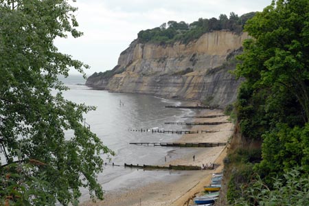
Click image to visit gallery of 2 images.
Shanklin and Sandown are two resorts on the east coast of the Isle of Wight that are conveniently connected by a section of the isle of Wight Coastal Path. The suggested start is Old Shanklin (grid ref. SZ581810) where there is a large pay and display car park from where the coastal path is easily reached. This path is then followed into the centre of Sandown from where there is a regular bus service back to Shanklin with a bust stop adjacent to the car park.
After parking follow Chine Avenue east towards the sea. It is only a few minutes walk. Reaching the top of the cliffs turn left and keeping, the sea on your right, follow the well maintained path. You are already able to enjoy excellent views back towards Shanklin Chine and ahead the sea front stretching all the way to Sandown. The path generally descends towards Sandown however there are some uphill sections although these are not unduly taxing.
The walking is generally easy and the path well signed. However in 2010 a section of the path was closed due to some erosion of the cliffs with a signed diversion in place. The path continues through the suburb of Lake and gradually descends to reach the shore at Sandown.
You should allow time to explore Sandown with its beach, pier, promenade and other seaside attractions before returning to the start by bus. Old Shanklin is also worth some time with a nice group of thatched buildings, some good cafes and restaurants and a range of shops.
An alternative method of travelling back from Sandown to Shanklin is by train. Less convenient and less frequent the railway uses some antique tube trains from London!
Maps 

| Ordnance Survey Explorer OL29 | Sheet Map | 1:25k | BUY |
| Anquet OS Explorer OL29 | Digital Map | 1:25k | BUY |
| Ordnance Survey Digital Map Subscription | |||
| Latest Ordnance Survey Discounts | |||
Other walks nearby
| Walk 3745 | Ventnor Downs Circular | moderate | 7.7 miles |
| Walk 2350 | Appuldurcombe Circular | easy/mod | 5.5 miles |
| Walk 2916 | Gatcombe and Shorwell from Carisbrooke, IOW | moderate | 10.0 miles |
| Walk 1751 | St Catherine's Hill & Coastal Path | moderate | 6.7 miles |
| Walk 3142 | Bowcombe Down | easy | 4.8 miles |
| Walk 1601 | Bowcombe Down & Upper Watchingwell | easy/mod | 8.0 miles |
| Walk 2435 | Compton Down circular | moderate | 12.5 miles |
| Walk 2414 | Compton Down and Five Barrows from Compton Chine | easy/mod | 5.0 miles |
| Walk 2311 | The Needles & Tennyson's Monument from Freshwater Bay | easy/mod | 6.0 miles |
| Walk 1546 | Yarmouth, Freshwater and Norton from Yarmouth | easy | 5.0 miles |
