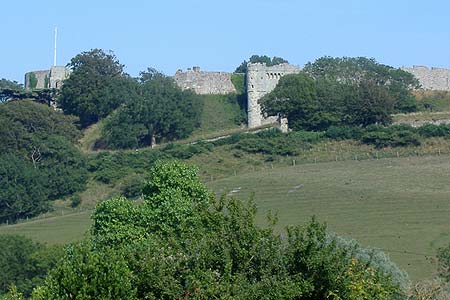
Gatcombe and Shorwell from Carisbrooke, IOW
Isle of Wight AONB Walk
Region - Isle of Wight AONB
County/Area - Isle of Wight
Author - Zelma Barnes
Length - 10.0 miles / 16.3 km Ascent - 1200 feet / 364 metres
Time - 6 hours 10 minutes Grade - moderate
Walk Route Description
Click image to visit gallery of 5 images.
This walk starts at the Priory Car Park in Whitcombe Road, Carisbrooke (Grid ref. SZ489875), which is located on the southwest outskirts of Newport (IOW). The route takes you through the hamlets of Gatcombe and Chillerton before bringing you back over Westridge and Dukern Downs with lovely views of Carisbrooke and the Castle providing a superb finale.
Leave the car park and walk west along the grass verge, keeping the Castle on your right, to the corner where Froglands Lane starts. Do not go down the lane but go left onto Bridleway N108. Called Dark Lane, this sunken track with its ferns and canopy of trees is very cool in summer and nicely sheltered from the elements in winter. It reminds you of "Jurassic Park"! When you come out of the lane go straight ahead and down and up the dip (G6). Go straight across when you meet the tractor track (grid ref. SZ485857) and continue down through the trees to the hunt kennels in Gatcombe.
At the metalled road (Grid ref. SZ485853) go right and then left into Newbarn Lane. At the end of this lane take the tractor track on your left (G6). At the top of the rise pass the footpath on your right and then turn right onto the Bridleway (G6) which is followed all the way to Chillerton.
At the metalled road (Grid ref. SZ485837) go left. Turn right down the next lane, Hollow Lane, which is Bridleway G15a. At the top of this lane go left and then at the signpost bear right (G15) (Note - the direction arrows have been moved). Keep the hedge on your left with the TV mast on the downs on your right. At the end of the hedge, walk approximately 100 metres and then bear left down the field with the hedge now on your right to reach a metalled road (Grid ref. SZ485826).
Turn right for a short way and then turn left down bridleway G15 towards Billingham. Follow this bridleway, ignoring any adjoining paths, until reach a metalled road (Grid ref. SZ484820). Turn left past the farm buildings and after 200 metres take bridleway SW43 on your right. This path goes around the edge of the field into a small track and then continues across two more fields to a metalled road (Grid ref. SZ474818).
Go right here and walk past Bucks Farm. After 500 metres turn right onto bridleway SW47 (Grid ref. SZ470821). This track starts off level but when you pass the copse becomes very steep to the top of the downs. At the top of the downs (Grid ref. SZ472827) go right and keep the field boundary on your immediate left taking the next lane left and go through the gate to the bottom of the downs (Grid ref. SZ475830). The route goes left then right up a sunken grassed track to the top of the down. This leads you onto a concrete road next to Chillerton TV mast.
Cross the road and take bridleway N146, which passes under the guy ropes for the mast. Follow this bridleway across the open fields, through the woods and down the next two fields where you exit via a jockey gate down a short but steep incline. At the bottom there is a disused lime kiln sat in amongst the trees on your left. Keep this copse on your left and at the bottom of the field (Grid ref. SZ 471861) go right along the tractor track. Reaching a farm track (Grid ref. SZ473863), go left and then take footpath N205 on your right to continue across an open field to a closed in lane (Grid ref. SZ475868). Go right here and follow this bridleway to its end at Froglands Farm and at the Y junction keep right up the metalled lane, Froglands Lane, to its junction with the main road. You will see the car park straight ahead of you, with the Castle now on your left.
Maps 

| Ordnance Survey Explorer OL29 | Sheet Map | 1:25k | BUY |
| Anquet OS Explorer OL29 | Digital Map | 1:25k | BUY |
| Ordnance Survey Digital Map Subscription | |||
| Latest Ordnance Survey Discounts | |||
Other walks nearby
| Walk 3142 | Bowcombe Down | easy | 4.8 miles |
| Walk 1601 | Bowcombe Down & Upper Watchingwell | easy/mod | 8.0 miles |
| Walk 2350 | Appuldurcombe Circular | easy/mod | 5.5 miles |
| Walk 2435 | Compton Down circular | moderate | 12.5 miles |
| Walk 1751 | St Catherine's Hill & Coastal Path | moderate | 6.7 miles |
| Walk 2112 | Shanklin to Sandown | easy | 3.0 miles |
| Walk 2414 | Compton Down and Five Barrows from Compton Chine | easy/mod | 5.0 miles |
| Walk 3745 | Ventnor Downs Circular | moderate | 7.7 miles |
| Walk 2311 | The Needles & Tennyson's Monument from Freshwater Bay | easy/mod | 6.0 miles |
| Walk 1546 | Yarmouth, Freshwater and Norton from Yarmouth | easy | 5.0 miles |
