Walk 2170 - printer friendly version
Eggleston & Mickleton from Romaldkirk Walk
Author - Lou Johnson
Length - 5.8 miles / 9.4 km
Ascent - 600 feet / 182 metres
Grade - easy/mod
Start - OS grid reference NY994220
Lat 54.5931860 + Long -2.0108006
Postcode DL12 9EB (approx. location only)
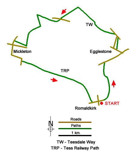
A circular walk from Romaldkirk in County Durham that explores Teesdale upstream to Eggleston and Mickleton. The route follows a section of the Teesdale Way north to Eggleston and Egglesburn. Crossing the River Tees the route passes through Mickleton to join the Tees Railway Walk for a leisurely return to the start. Along the route there is a mixture of riverside walking, pastures and woodland.
The start of the walk is the village green on the east side of the B6277 in R (grid ref. NY994220). On street parking is available nearby. After parking walk east past the Rose and Crown (on your left). Continue past the church and fork right along a no through road. After 150 metres turn left onto the Teesdale Way (fingerpost on the right of the road). Follow the walled path north to pass between trees and turn left at a fingerpost (grid ref. Ny997224) to head north across pastures. The route then turns left following the edge of woodland on your right and continues to the B6281).
Turn right along the road, cross the River Tees and continue 500 metres to the next road junction. Turn left (signed to Middleton in Teesdale). After 200 metres turn right uphill. Turn left just before the green and almost immediately right uphill. Pass the Three Tuns Inn on your left and then bear left along the B6278. At the next junction fork left along Balmer Lane (a no through road). As you make progress along the lane you get a fine view up Teesdale.
Take the first signed footpath on the left through a gate to continue along the Teesdale Way. The path crosses pastures to reach a group of houses at New Town where you join an access track. Continue ahead to reach a tarmac lane (grid ref. NY991246). Walk straight ahead and continue along a track through trees to reach another lane. Turn left along the lane and continue to the B6282). Turn right and then almost immediately left at a fingerpost down a driveway with a bench to your right. Follow the track around to the right. Where the track bends left keep ahead and follow a grassy path down to the banks of the River Tees (grid ref. NY976246).
Leave the Teesdale Way and turn left along the river. Continue to Beckstones Wath Bridge and cross the Tees. The path heads slightly left across fields to join a narrow track on the right that leads to join narrow Yanker Lane (grid ref. NY973239). Turn left along the lane and continue to a T-junction. Turn right along Low Side to the next T-junction and turn left up to the B6277. Turn left and then take the first road on the right (Brown sign to Tees Railway Walk). Continue along the lane forking right into the Mickleton Picnic Area. Turn left along the Tees Railway Walk and continue for three kilometres to reach a road on the outskirts of Romaldkirk. Turn left along Fell lane back to the start.
Messaging & Social Media
Message Walking Britain and follow the latest news.

Mountain Weather
Stay safe on the mountains with detailed weather forecasts - for iOS devices or for Android devices.