Eggleston & Mickleton from Romaldkirk
Durham Walk
County/Area - Durham
Author - Lou Johnson
Length - 5.8 miles / 9.4 km Ascent - 600 feet / 182 metres
Time - 3 hours 30 minutes Grade - easy/mod
Walk Route Description
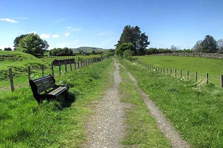
Click image to see photo description.
A circular walk from Romaldkirk in County Durham that explores Teesdale upstream to Eggleston and Mickleton. The route follows a section of the Teesdale Way north to Eggleston and Egglesburn. Crossing the River Tees the route passes through Mickleton to join the Tees Railway Walk for a leisurely return to the start. Along the route there is a mixture of riverside walking, pastures and woodland.
The start of the walk is the village green on the east side of the B6277 in R (grid ref. NY994220). On street parking is available nearby. After parking walk east past the Rose and Crown (on your left). Continue past the church and fork right along a no through road. After 150 metres turn left onto the Teesdale Way (fingerpost on the right of the road). Follow the walled path north to pass between trees and turn left at a fingerpost (grid ref. Ny997224) to head north across pastures. The route then turns left following the edge of woodland on your right and continues to the B6281).
Turn right along the road, cross the River Tees and continue 500 metres to the next road junction. Turn left (signed to Middleton in Teesdale). After 200 metres turn right uphill. Turn left just before the green and almost immediately right uphill. Pass the Three Tuns Inn on your left and then bear left along the B6278. At the next junction fork left along Balmer Lane (a no through road). As you make progress along the lane you get a fine view up Teesdale.
Take the first signed footpath on the left through a gate to continue along the Teesdale Way. The path crosses pastures to reach a group of houses at New Town where you join an access track. Continue ahead to reach a tarmac lane (grid ref. NY991246). Walk straight ahead and continue along a track through trees to reach another lane. Turn left along the lane and continue to the B6282). Turn right and then almost immediately left at a fingerpost down a driveway with a bench to your right. Follow the track around to the right. Where the track bends left keep ahead and follow a grassy path down to the banks of the River Tees (grid ref. NY976246).
Leave the Teesdale Way and turn left along the river. Continue to Beckstones Wath Bridge and cross the Tees. The path heads slightly left across fields to join a narrow track on the right that leads to join narrow Yanker Lane (grid ref. NY973239). Turn left along the lane and continue to a T-junction. Turn right along Low Side to the next T-junction and turn left up to the B6277. Turn left and then take the first road on the right (Brown sign to Tees Railway Walk). Continue along the lane forking right into the Mickleton Picnic Area. Turn left along the Tees Railway Walk and continue for three kilometres to reach a road on the outskirts of Romaldkirk. Turn left along Fell lane back to the start.
Maps 

| Ordnance Survey Explorer OL31 | Sheet Map | 1:25k | BUY |
| Anquet OS Explorer OL31 | Digital Map | 1:25k | BUY |
| Ordnance Survey Digital Map Subscription | |||
| Latest Ordnance Survey Discounts | |||
Other walks nearby
| Walk 2228 | Romaldkirk Moor | easy/mod | 7.6 miles |
| Walk 2767 | Lartington & Cotherstone Circular | easy/mod | 6.8 miles |
| Walk 1005 | Harter Fell & Grassholme | moderate | 8.0 miles |
| Walk 1482 | Crossthwaite Common from Middleton-in-Teesdale | moderate | 9.8 miles |
| Walk 1483 | Eggleston & Romaldkirk from Middleton-in-Teesdale | easy/mod | 9.8 miles |
| Walk 1484 | Kirkcarrion from Middleton-in-Teesdale | easy | 3.5 miles |
| Walk 1485 | Hamsterley & Middleton-in-Teesdale | mod/hard | 16.5 miles |
| Walk 1488 | Middleton-in-Teesdale Railway Walk | easy | 2.5 miles |
| Walk 2258 | Grassholme Reservoir from Middleton-in-Teesdale | moderate | 8.2 miles |
| Walk 1553 | Hannah's Meadow, Baldersdale & Brown Rigg Moss | easy/mod | 8.0 miles |
Recommended Books & eBooks
Walking in County Durham
 Guidebook offering detailed descriptions of 40 day walks, plus 10 traffic-free cycle routes along old railway trackbeds. Together they cover 450 miles and spread all over County Durham to show the region's history and natural wonders. The terrain covered ranges from field paths to open moorlands, from the North Sea to the high Pennines.
More information
