Walk 2171 - printer friendly version
Knighton Hill & the Ox Drove Walk
Author - Lou Johnson
Length - 5.8 miles / 9.4 km
Ascent - 620 feet / 188 metres
Grade - easy/mod
Start - OS grid reference SU040253
Lat 51.0270540 + Long -1.9443389
Postcode SP5 5DW (approx. location only)
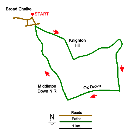
A Wiltshire walk from Broad Chalke exploring the beautiful downs to the southeast of the village. The undulating route uses paths and tracks to climb onto Knighton Hill which as the highest point of the walk offers an excellent view north across the Ebble Valley. The walk continues across the downs following tracks to pass through the Middleton Down Nature Reserve back to the start.
Limited on street parking is available on South Street near the parish church (grid ref. SU040253). After parking walk east along South Street passing the church on your left. At the next junction turn right and follow the lane up to a crossroad (grid ref. SU042252) where you take the track opposite (signed as a bridleway). After 100 metre along the track turn left at the waymark into a large field. Bear half right along a grassy track and continue into the next field (grid ref. SU048248). Bear right and if the field is cropped keep to the left-hand side of the field and follow the hedge into the field corner where you turn left for 200 metres to join a path on the right (grid ref. SU053242). Reaching a wide grassy track, turn left and pass Knighton Hill Farm on your left.
Maintain direction past the farm joining a clear farm track. Where this track bends left, continue ahead to walk down Bishopstone Hollow (track) which soon becomes enclosed by hedges. Reaching a T-junction of tracks, with a barn on your left, turn right onto a track (Croucheston Drove). Follow this as it twists uphill for 1.4 kilometres to a fingerpost (grid ref. SU067232). Turn right along a track between hedges. After 800 metres you reach a well-defined cross track (grid ref. SU060232). Turn right and almost immediately left along the Ox Drove. After 800 metres (grid ref. SU052229) turn right downhill on a track passing through the Middleton Down Nature Reserve. The track briefly passes through woodland before continuing downhill into Broad Chalke.
Messaging & Social Media
Message Walking Britain and follow the latest news.

Mountain Weather
Stay safe on the mountains with detailed weather forecasts - for iOS devices or for Android devices.