Dodd Fell Hill & Drumaldrace from Hawes
Yorkshire Dales Walk
Nat Park - Yorkshire Dales - Wensleydale
County/Area - North Yorkshire
Author - Lou Johnson
Length - 11.5 miles / 18.7 km Ascent - 1800 feet / 545 metres
Time - 7 hours 30 minutes Grade - moderate
Walk Route Description
Click image to see photo description.
This walk from Hawes visits Dodd Fell Hill and Drumaldrace (Wether Fell) which both exceed 610 metres in height so are considered mountains in England and Wales. The route generally follows clear paths, including a section of the Pennine Way, and tracks. The views throughout are excellent including Wensleydale and other fells in the area.
The start is the car park at the Hawes National Park Centre (grid ref. SD876899). After parking follow the access road back to the A684, cross the road and bear right and continue into the town centre. Reaching the church on your left, go through the gate into the churchyard, walk past the church and continue ahead at a path junction to follow the Pennine Way. Reaching the road in Gayle, turn left and just before a bus shelter on the right follow a path between houses. Cross a road and continue into a field. Walk half left across the field to a lane. Turn right and follow the lane through West End (Gayle). Reaching the end of 30 mph sign, go through a small gate on the left (grid ref. SD868891).
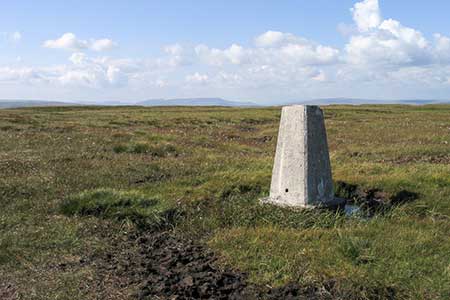
Follow the path with a wall on your right for 150 metres and turn left across two fields to a walled track. Turn right and then first left along Gaudy Lane. Just before reaching Gaudy House, fork left through a gate onto West Cam Road. After just under three kilometres Cam Road comes in from the right. Continue ahead for a further two kilometres with Dodd Fell Hill rising to the left of the track. At grid ref. SD836847 you reach a wall on the left. Leave the Pennine Way and head up over pathless moor to the OS trig column (668 m.). The view includes the Three Peaks and other more distant fells. From the trig column head southeast aiming for head of Sleddale, avoiding height loss as much as you can. During the descent you will see improved fields enclosed by walls. After rounding the head of Sleddale, walk due east keeping close the walled fields on your right. Continue over easier ground to reach Cam Road (grid ref. SD855842).
Bear left along unfenced Cam Road. Continue ahead where the.road from Kettlewell comes in from the right. After 600 metres the road starts to descend to Hawes. Fork right onto the clear Track (Cam Road). Pass through a gate and continue ahead. The track soon becomes enclosed by walls. When the wall on the left ends at a gate, pass through the gate and head half-left on a rising path that takes you to the summit of Drumaldrace (614 m.). The highest point is marked by a small cairn. The views include Baugh Fell, Wild Boar Fell and the Howgills.
Return to the Cam Road and continue until a wall comes in from the left. Turn left through a gate near the wall corner and follow a bridleway that heads roughly north. After passing through a wall the path joins a grassy track. The track becomes more distinct after passing a wall corner (grid ref. SD883879) and leads down to a road in Burtersett. Turn right and just after a former chapel, turn left down a signed footpath. Go straight across the first field, half-right across the second, maintain direction across the next to a path junction (grid ref. SD888894). Bear left here and cross three walls. With a stone barn ahead, veer half-right, and follow the clear path to a lane. Cross the lane to a signed path slightly left and continue back to the A684 in Hawes. Turn left and return to the start.
Maps 

| Ordnance Survey Explorer OL30 | Sheet Map | 1:25k | BUY |
| Anquet OS Explorer OL30 | Digital Map | 1:25k | BUY |
| Ordnance Survey Digital Map Subscription | |||
| Latest Ordnance Survey Discounts | |||
Other walks nearby
| Walk 2363 | Drumaldrace (Wether Fell) from Burtersett | easy/mod | 5.2 miles |
| Walk 3624 | Great Shunner Fell from Hardraw | mod/hard | 9.2 miles |
| Walk 3621 | Great Shunner Fell & Lovely Seat | mod/hard | 11.4 miles |
| Walk 2155 | Mossdale & Cotterdale | easy/mod | 7.9 miles |
| Walk 2265 | Semer Water, Stalling Busk & Marsett | easy | 4.0 miles |
| Walk 3524 | Semer Water and Cam High Road | easy/mod | 5.7 miles |
| Walk 2822 | Aysgarth & Castle Bolton | mod/hard | 14.5 miles |
| Walk 1694 | Nappa Hall & Whitfield Gill Force | easy/mod | 6.0 miles |
| Walk 1053 | Swinner Gill and Muker | mod/hard | 8.5 miles |
| Walk 2409 | The Upper Eden valley without a car | moderate | 12.0 miles |
Recommended Books & eBooks
Walking in the Yorkshire Dales: North and East
 This guidebook contains 43 circular day walks in the north and east Yorkshire Dales. It explores the dales, hills and moors between Kirkby Stephen and Pateley Bridge. Walking ranges from gentle 3 mile strolls to more strenuous day-long rambles across the Howgills, Wensleydale, Swaledale, Nidderdale, Mallerstang and Coverdale.
More information
The Pennine Way - the Path, the People, the Journey
 A portrait of the The Pennine Way, Britain's oldest and best known long-distance footpath, stretching 268 miles from the Peak District to the Scottish Borders. This personal, thoughtful and often humorous story of the path's remarkable history, includes the experiences of walkers and local characters on this exhilarating and complex path.
More information
