Drumaldrace (Wether Fell) from Burtersett
Yorkshire Dales Walk
Nat Park - Yorkshire Dales - Wensleydale
County/Area - North Yorkshire
Author - Lou Johnson
Length - 5.2 miles / 8.5 km Ascent - 900 feet / 273 metres
Time - 3 hours 30 minutes Grade - easy/mod
Walk Route Description
Click image to see photo description.
carbonate.cubed.tinned
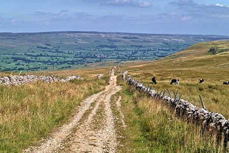
Drumaldrace (614 m.) or Wether Fell lies on the southern side of Wensleydale and the summit offers fine views into the valley and the fells beyond. The route starts from the village of Burtersett which is a short drive south of the A684 to the east of Hawes. The walk follows clear tracks and paths, and the ascent is gradual and never too demanding.
The start id the bend at the top Burtersett village (grid ref. SD891892) where there is space for a few cars. After parking, take the lane running beside a converted chapel. Almost immediately fork left to join a clear track which climbs steadily onto the hillside. The track follows a sinuous route uphill passing through several gates. The route is never in doubt with the prominent feature of Yorburgh rising on your right. Stay with the track which fades for a short distance to reach a gate (grid ref. SD883877). From here the tracks twists and turns heading roughly west to the final gate of the ascent.
Once through the gate, turn right and follow a path with a wall on your immediate right. Stay with the wall for about a kilometre with some sections of the path wet underfoot. Counting from the gate continue to the point where the fourth wall junction is reached (grid ref. SD870869) and turn left on a feint path to the summit of Drumaldrace. Allow time to enjoy the extensive view. From the cairn descend a steep slope to join a clear track, Cam High Road, which is a former Roman Road.
Turn left along the walled track to reach a gate. The onward track descends steadily towards Bainbridge. Continue two the point where there are footpath fingerposts on either side of the track each with adjacent metal gate (grid ref. SD895878). Turn left over the stone wall stile and descend a pasture to a stile. Once across the stile maintain direction, cross a gully with a stream to reach the next stile, with a wall corner on the right. After a short distance Burtersett comes into view. The path crosses a broken wall and heads to the far right-hand corner of a plantation. Another three stiles takes us back to a lane in Burtersett. Turn left back to the starting point.
Maps 

| Ordnance Survey Explorer OL30 | Sheet Map | 1:25k | BUY |
| Anquet OS Explorer OL30 | Digital Map | 1:25k | BUY |
| Ordnance Survey Digital Map Subscription | |||
| Latest Ordnance Survey Discounts | |||
Other walks nearby
| Walk 2273 | Dodd Fell Hill & Drumaldrace | moderate | 11.5 miles |
| Walk 2286 | Gayle & Aysgill Force from Hawes | easy | 3.5 miles |
| Walk 3624 | Great Shunner Fell from Hardraw | mod/hard | 9.2 miles |
| Walk 3621 | Great Shunner Fell & Lovely Seat | mod/hard | 11.4 miles |
| Walk 2265 | Semer Water, Stalling Busk & Marsett | easy | 4.0 miles |
| Walk 2155 | Mossdale & Cotterdale | easy/mod | 7.9 miles |
| Walk 3524 | Semer Water and Cam High Road | easy/mod | 5.7 miles |
| Walk 2822 | Aysgarth & Castle Bolton | mod/hard | 14.5 miles |
| Walk 1694 | Nappa Hall & Whitfield Gill Force | easy/mod | 6.0 miles |
| Walk 1053 | Swinner Gill and Muker | mod/hard | 8.5 miles |
Recommended Books & eBooks
Walking in the Yorkshire Dales: North and East
 This guidebook contains 43 circular day walks in the north and east Yorkshire Dales. It explores the dales, hills and moors between Kirkby Stephen and Pateley Bridge. Walking ranges from gentle 3 mile strolls to more strenuous day-long rambles across the Howgills, Wensleydale, Swaledale, Nidderdale, Mallerstang and Coverdale.
More information
Walking in the Yorkshire Dales: South and West
 Part of a two-book set, this guidebook describes 44 walks in the southern and western Yorkshire Dales, including the famous 23 mile Three Peaks circuit over Pen-y-Ghent, Whernside and Ingleborough. The other, mostly circular routes of 3½ to 13 miles cover the scenic region between Sedbergh, Kirkby Lonsdale, Settle, Skipton and Grassington.
More information
