Lune Valley from Kirkby Lonsdale
Cumbria Walk
County/Area - Cumbria - South Cumbria
Author - Lou Johnson
Length - 6.1 miles / 9.9 km Ascent - 350 feet / 106 metres
Time - 3 hours 20 minutes Grade - easy
Walk Route Description
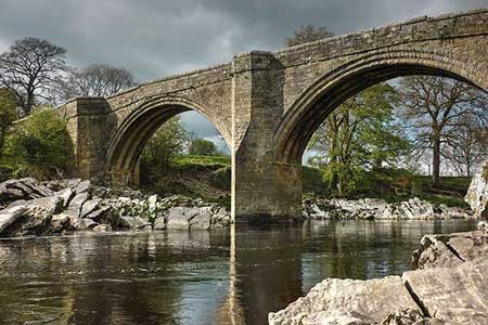
Click image to see photo description.
Starting from the interesting market town of Kirkby Lonsdale, this circular walk explores the countryside and Lune Valley lying to the south of the town. The route follows signed paths, a quiet lane, and a section of the Lune Vally Ramble. In Kirkby Lonsdale you can enjoy Ruskin's View, Devil's Bridge and, if time permits, visit St. Mary's Church.
The start is Devil's Bridge (grid ref. SD616782) where several parking options are available. After parking walk to the bridge and descend to the clear path and walk north with the River Lune on your right. Follow the riverside path as it sweeps left to pass The Island midstream. Turn left up the Radical Steps. At the top of the steps turn right and walk a short way to enjoy Ruskin's View. Return to the steps and turn right across the churchyard keeping St. Mary's on your immediate left. Exit the churchyard and walk along narrow Church Street opposite. Turn right into Market Street and then fork left up Mitchelgate. Continue to the B6446 and fork right uphill. Continue a short distance and then fork left along Biggins Road. Reaching tennis courts on the left, turn left onto a signed footpath and continue to the A65 (grid ref. SD607785).
Cross the road with care and join the signed footpath opposite at the top of a flight of steps. The path maintains direction across three fields and then heads half right to a gate and a two-way fingerpost on a lane near Wood End Farm. Turn left and follow a walled lane south for 500 metres to reach a farm near Sellet Mill. Turn right on a signed footpath just before the farm buildings and continue across fields passing Sellet Hall on your left to a stile and a lane (grid ref. SD599774).
Turn left along Hosticle Lane for just over a kilometre to a T-junction in the village of Whittingham. Turn left and then right onto a signed footpath leading into the churchyard of St Michael the Archangel. Pass the church on your left and follow the path down to the lower graveyard. The path runs beside a hedge on your left to a fork in the path. Bear right and follow the path which eventually passes through some trees to exit at a gate onto a road. Turn left and after 100 metres bear right to join a signed bridleway. Follow the track (Burrow Mill Lane) with Low Hall Farm on your left and continue to reach the River Lune. (Note the track bends sharp right and then left before reaching the river).
Turn left along the riverside path to follow the Lune Valley Ramble. Three kilometres of relaxing walking leads under the A65 at Stanley Bridge and shortly after you return to Devil's Bridge in Kirkby Lonsdale.
Maps 

| Ordnance Survey Explorer OL2 | Sheet Map | 1:25k | BUY |
| Anquet OS Explorer OL2 | Digital Map | 1:25k | BUY |
| Ordnance Survey Digital Map Subscription | |||
| Latest Ordnance Survey Discounts | |||
Other walks nearby
| Walk 2501 | Devil's Bridge, Kirkby Lonsdale | easy | 1.5 miles |
| Walk 2376 | Gragareth from Leck | moderate | 9.3 miles |
| Walk 3584 | Gragareth from Ireby | moderate | 7.4 miles |
| Walk 3032 | Gragareth & Great Coum from Yordas Cave | moderate | 9.0 miles |
| Walk 3091 | Ingleton Waterfalls Walk | easy | 4.3 miles |
| Walk 2256 | Great Stone of Fourstones | easy/mod | 6.7 miles |
| Walk 1052 | Whernside & Dentdale | mod/hard | 12.0 miles |
| Walk 3233 | Dent & Gawthrop | easy/mod | 6.0 miles |
| Walk 1208 | Ingleborough & Park Fell | moderate | 7.5 miles |
| Walk 3500 | Ingleborough (northern approach) | moderate | 9.5 miles |
Recommended Books & eBooks
Outdoor Adventures with Children - Lake District
 Guidebook to 40 outdoor adventures in the Lake District with children under 12, including walking, cycling, orienteering, paddling, boating, hostelling and more. Graded activities for varying age ranges or for families with children of different ages.
More information
Walking the Lake District Fells - Langdale
 Part of the Walking the Lake District Fells series, this guidebook covers a wide range of routes to 25 Lakeland summits that can be climbed from the Great Langdale valley, Ambleside and Grasmere, with highlights including Scafell Pike, Bowfell, the Langdale Pikes and Helm Crag (the Lion and the Lamb). Includes suggestions for longer ridge routes.
More information
