Gragareth from Ireby
Yorkshire Dales Walk
Nat Park - Yorkshire Dales - Three Peaks Country
County/Area - Lancashire & North Yorkshire
Author - Lou Johnson
Length - 7.4 miles / 12 km Ascent - 1500 feet / 455 metres
Time - 5 hours 10 minutes Grade - moderate
Walk Route Description
Click image to see photo description.
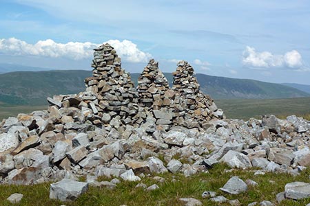
This Yorkshire Dales walk in Lancashire walk explores the lonely landscape of Gragareth which rises to the west of Kingsdale. The summit sees few walkers yet offers fine views east to Whernside and Ingleborough and west to Morecambe Bay. During the ascent you will pass the three cairns known as the "Three Men of Gragareth".
The start is the village of Ireby where limited on street parking is available (grid ref. SD654755). After parking walk south to the road junction and turn right signed to Leck. After 500 metres, the lane bears left near Todgill Farm (grid ref. SD652759). From here walk straight ahead on an enclosed track. Follow this track for about two kilometres to reach a lane at a metal gate (grid ref. SD657776). Turn right along the lane and continue climbing with a distant view to Morecambe Bay on your left. You already have a sense of the isolated nature of this area.
Pass through a metal gate and continue up the lane to where it goes left to Leck House Farm (grid ref. SD676791). Go through the wooden gate on the right onto a clear track. Follow a very feint path which leaves the track on the right just after passing through the gate. The path soon fades, and you need to take advantage of the grassy areas amid the boulders to ease the steep ascent up to the "Three Men of Gragareth", which come into view as you gain height. Once the cairns have been reached head east on a clear path ignoring cross paths and tracks to reach the trig point on Gragareth (grid ref. SD688793). With most of the ascent now complete it is a perfect place for a rest and to enjoy the view.
Leave the summit on a path leading east to reach a wall (the boundary of Lancashire and North Yorkshire). Turn right along the wall (wall on your left) and head south to a wall junction with a stile. Cross the stile and continue alongside the wall (wall now on your right) and continue over a stile. Maintain direction parallel with the wall and continue to reach a stone stile on the right by a derelict wooden stile (grid ref. SD667772). Turn right over the stile and follow the path which leads to the left of Ireby Fell Cavern (grid ref. SD673773). Continue half left to reach a wall.
Turn left along the wall (wall on your right). There is some soft ground which can be easily avoided. However, do keep as close to the wall as you can as this provides a perfect navigational aid. Continue down until you see a tree by a wall (grid ref. SD768650). Initially aim for the tree to locate a track heading southwest. Follow the track downhill to reach a pair of gates just to the left of a paid of barns (High Barn). Take the left-hand gate and follow the track down to a lane. Bear left and return to the start.
Maps 

| Ordnance Survey Explorer OL2 | Sheet Map | 1:25k | BUY |
| Anquet OS Explorer OL2 | Digital Map | 1:25k | BUY |
| Ordnance Survey Digital Map Subscription | |||
| Latest Ordnance Survey Discounts | |||
Other walks nearby
| Walk 2376 | Gragareth from Leck | moderate | 9.3 miles |
| Walk 2372 | Lune Valley from Kirkby Lonsdale | easy | 6.1 miles |
| Walk 3091 | Ingleton Waterfalls Walk | easy | 4.3 miles |
| Walk 2501 | Devil's Bridge, Kirkby Lonsdale | easy | 1.5 miles |
| Walk 3032 | Gragareth & Great Coum from Yordas Cave | moderate | 9.0 miles |
| Walk 2256 | Great Stone of Fourstones | easy/mod | 6.7 miles |
| Walk 1208 | Ingleborough & Park Fell | moderate | 7.5 miles |
| Walk 3500 | Ingleborough (northern approach) | moderate | 9.5 miles |
| Walk 1248 | Trow Gill, Ingleborough & Long Scar | moderate | 9.5 miles |
| Walk 2796 | Ingleborough via Gaping Gill & Norber | moderate | 13.0 miles |
Recommended Books & eBooks
Walking on the West Pennine Moors
 This guidebook describes 30 walks on the West Pennine Moors, around Blackburn, Darwen, Chorley and Bolton, home to some of the most inspiring and exhilarating walking country. The walks range from short, easy rambles to more challenging hikes covering a variety of terrain, all of it easily accessible for day walking.
More information
Walking in the Yorkshire Dales: South and West
 Part of a two-book set, this guidebook describes 44 walks in the southern and western Yorkshire Dales, including the famous 23 mile Three Peaks circuit over Pen-y-Ghent, Whernside and Ingleborough. The other, mostly circular routes of 3½ to 13 miles cover the scenic region between Sedbergh, Kirkby Lonsdale, Settle, Skipton and Grassington.
More information
