Walk 2382 - printer friendly version
Smiddy Shaw Reservoir Circular Walk
Author - Lou Johnson
Length - 6.2 miles / 10.1 km
Ascent - 600 feet / 182 metres
Grade - easy/mod
Start - OS grid reference NZ050453
Lat 54.8025510 + Long -1.9237445
Postcode DH8 9DZ (approx. location only)
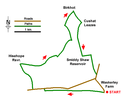
A circular moorland walk from Waskerley Farm including Hisehope and Smiddy Shaw Reservoirs. The route uses a section of the Waskerley Way along a former railway before heading north across open moor to visit the two reservoirs. In places care is needed with navigation as there are few landmarks in some sections of the route.
The walk starts from the car park adjacent to Waskerley Farm (grid ref. NZ050453). After parking exit the car park through the gate and turn right along the former railway. After just under two kilometres of easy walking you reach a road and parking area at Hawkburn Head. Leave the old railway and turn right up to a T-junction and turn left. After 350 metres turn right onto a clear track. Follow this to reach Hisehope Reservoir. Just before the reservoir you pass a house. Proceed ahead to view the reservoir then retrace your steps to just before the house and turn left on a path beside a water channel (grid ref. NZ024462). Continue for a kilometre to reach a footbridge just beyond a right-hand bend (grid ref. NZ036465).
Leave the channel and turn left along a moorland path which soon crosses a minor channel. After 500 metres you reach Backstone Burn. Cross the burn and turn left and follow a path running roughly parallel to the stream to where it joins Hisehope Burn (grid ref. NZ039474). Cross the burn and follow path northwest with an enclosed field on your right. Continue for 120 metres and turn right through a gate into a field. Follow a grassy track and continue towards Birkhot Farm. Just before the farm bear right beside a wall and continue to a clear track (grid ref. NZ041479). Turn right along the track and continue to the ruined farm of Cushat Leazes.
Just past the ruins, bear right along a grassy path which leads via a gate a in a wall to Smiddy Shaw Reservoir after a kilometre. Climb the steps and turn left and follow the path as it swings right and continues to a parking area. Fork left and continue to a road. Turn left and then fork left to return to Waskerley Farm.
Messaging & Social Media
Message Walking Britain and follow the latest news.

Mountain Weather
Stay safe on the mountains with detailed weather forecasts - for iOS devices or for Android devices.