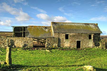
Smiddy Shaw Reservoir Circular from Waskerley Farm
Durham Walk
County/Area - Durham
Author - Lou Johnson
Length - 6.2 miles / 10.1 km Ascent - 600 feet / 182 metres
Time - 3 hours 40 minutes Grade - easy/mod
Walk Route Description
Click image to see photo description.
A circular moorland walk from Waskerley Farm including Hisehope and Smiddy Shaw Reservoirs. The route uses a section of the Waskerley Way along a former railway before heading north across open moor to visit the two reservoirs. In places care is needed with navigation as there are few landmarks in some sections of the route.
The walk starts from the car park adjacent to Waskerley Farm (grid ref. NZ050453). After parking exit the car park through the gate and turn right along the former railway. After just under two kilometres of easy walking you reach a road and parking area at Hawkburn Head. Leave the old railway and turn right up to a T-junction and turn left. After 350 metres turn right onto a clear track. Follow this to reach Hisehope Reservoir. Just before the reservoir you pass a house. Proceed ahead to view the reservoir then retrace your steps to just before the house and turn left on a path beside a water channel (grid ref. NZ024462). Continue for a kilometre to reach a footbridge just beyond a right-hand bend (grid ref. NZ036465).
Leave the channel and turn left along a moorland path which soon crosses a minor channel. After 500 metres you reach Backstone Burn. Cross the burn and turn left and follow a path running roughly parallel to the stream to where it joins Hisehope Burn (grid ref. NZ039474). Cross the burn and follow path northwest with an enclosed field on your right. Continue for 120 metres and turn right through a gate into a field. Follow a grassy track and continue towards Birkhot Farm. Just before the farm bear right beside a wall and continue to a clear track (grid ref. NZ041479). Turn right along the track and continue to the ruined farm of Cushat Leazes.
Just past the ruins, bear right along a grassy path which leads via a gate a in a wall to Smiddy Shaw Reservoir after a kilometre. Climb the steps and turn left and follow the path as it swings right and continues to a parking area. Fork left and continue to a road. Turn left and then fork left to return to Waskerley Farm.
Maps 

| Ordnance Survey Explorer 307 | Sheet Map | 1:25k | BUY |
| Anquet OS Explorer 307 | Digital Map | 1:25k | BUY |
| Ordnance Survey Digital Map Subscription | |||
| Latest Ordnance Survey Discounts | |||
Other walks nearby
| Walk 2089 | College Edge & Cuthbert's Currick from Edmundbyers | easy/mod | 8.0 miles |
| Walk 1948 | Tunstall Reservoir | easy/mod | 7.3 miles |
| Walk 1955 | Sunnyside Edge from Wolsingham | easy/mod | 7.5 miles |
| Walk 3315 | Warlaw Pike & Birkside Fell from Blanchland | moderate | 8.0 miles |
| Walk 3722 | Buckshott Fell & Sikehead Mines | easy/mod | 6.5 miles |
| Walk 2815 | Pennypie and Blanchland from Baybridge | easy/mod | 3.8 miles |
| Walk 3634 | Catterick Moss & Bollihope Carrs | moderate | 5.6 miles |
| Walk 2393 | Weardale Circular from Westgate | easy/mod | 6.4 miles |
| Walk 1942 | Watson's Pike & Hexhamshire Common | easy/mod | 6.0 miles |
| Walk 1659 | Race Head & Sedling Rake from Wearhead | easy/mod | 6.0 miles |
Recommended Books & eBooks
Walking in County Durham
 Guidebook offering detailed descriptions of 40 day walks, plus 10 traffic-free cycle routes along old railway trackbeds. Together they cover 450 miles and spread all over County Durham to show the region's history and natural wonders. The terrain covered ranges from field paths to open moorlands, from the North Sea to the high Pennines.
More information
