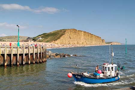
West Bay & Burton Cliff
Jurassic Coast Walk
Region - Jurassic Coast
County/Area - Dorset
Author - Lou Johnson
Length - 4.5 miles / 7.3 km Ascent - 400 feet / 121 metres
Time - 2 hours 40 minutes Grade - easy
Walk Route Description
Click image to see photo description.
An interesting walk from West Bay (Dorset) exploring the coast southeast to Burton Bradstock. The outward route follows the South West Coast Path over East Cliff which consists of layers of Fuller's Earth. The walk then descends to Birton Freshwater Beach before continuing onto Burton Cliff as far as Hive Beach. Turning inland the route returns to West Bay using a short section of the Hardy Way.
The walk starts from the large car park behind the beach in West Bay (grid ref. SY464903). It is worth allowing time to visit the pretty, bustling harbour either at the beginning or end of the walk. After parking welk across the beach towards the sea. Bear half left to join the coast path which after an initial climb reaches the top of East Cliff. The path undulates near the cliff offering fine views along the coast. After a kilometre, the path descends to the beach at Burton Freshwater. The path follows the rear of the beach and then continues along the north bank of the River Bride to a footbridge (grid ref. SY482896).
Cross the bridge and turn sharp right to continue along the South West Coast Path. Which arcs left to reach the path over Burton Cliff and continue to Hive Beach with its convenient café. After refreshments retrace your steps for 250 metres and turn right onto a path signed to Burton Bradstock. The path runs on the left-hand side of a car park before heading half-right across a field to a path junction in the far corner. Turn right towards Burton Bradstock and continue to the village outskirts to exit onto Cliff Road. Bear right and then first left into Southover. At the end of the road continue ahead on the clear footpath. Ignore a path on the left and continue ahead to reach the footbridge crossed earlier in the walk.
Cross the river and turn left along the SWCP. After 200 metres turn right onto signed path. Keep ahead to reach a service road, turn left, pass the site reception and then right uphill passing between permanent mobile homes. Where the driveway turns right, turn left through gate and shortly after right as indicated by a sign. The onward path crosses Bridport & West Dorset golf course and is waymarked. You are asked to stay on the marked path and be aware of flying golf balls. Continue across the course to reach a stile. Cross the stile and turn right downhill to a lane. Turn left and continue back to the car park in West Bay.
Maps 

| Ordnance Survey Explorer OL15 | Sheet Map | 1:25k | BUY |
| Anquet OS Explorer OL15 | Digital Map | 1:25k | BUY |
| Ordnance Survey Digital Map Subscription | |||
| Latest Ordnance Survey Discounts | |||
Other walks nearby
| Walk 1549 | Golden Cap from Seatown | easy/mod | 4.0 miles |
| Walk 3629 | Eggardon Hill from Loders | moderate | 8.4 miles |
| Walk 2494 | West Bexington & Abbotsbury Circular | moderate | 7.7 miles |
| Walk 3265 | Eggardon Hill from Powerstock | easy/mod | 6.3 miles |
| Walk 2580 | Golden Cap & Charmouth | easy/mod | 5.0 miles |
| Walk 1551 | Seatown and Charmouth via Golden Cap | easy/mod | 5.0 miles |
| Walk 2565 | Littlebredy from Abbotsbury | moderate | 8.5 miles |
| Walk 2827 | Rodden & Langton Herring from Abbotsbury | easy/mod | 9.2 miles |
| Walk 2289 | Abbotsbury Castle and Chesil Beach | easy/mod | 6.0 miles |
| Walk 2771 | Lyme Regis & Uplyme Circular | easy/mod | 5.5 miles |
Recommended Books & eBooks
South West Coast Path Map Booklet - St Ives to Plymouth
 Map of part of the southern section of the 630 mile (1014km) South West Coast Path National Trail. Covers the trail from St Ives to Plymouth along the west Cornwall and Devon coastline. This convenient and compact booklet of Ordnance Survey 1:25,000 maps shows the route, providing all of the mapping you need to walk the trail in either direction.
More information
The South West Coast Path
 Guidebook to walking the entire South West Coast Path National Trail. The route runs for 630 miles from Minehead to Poole along the north Devon, Cornish, south Devon and Dorset coastline. Divided into 45 stages, this long-distance coastal trek could be completed within 4 weeks, or walked in sections. Guide includes maps and essential information.
More information
