Eggardon Hill from Loders
Dorset Walk
County/Area - Dorset
Author - Lou Johnson
Length - 8.4 miles / 13.7 km Ascent - 900 feet / 273 metres
Time - 5 hours 10 minutes Grade - moderate
Walk Route Description
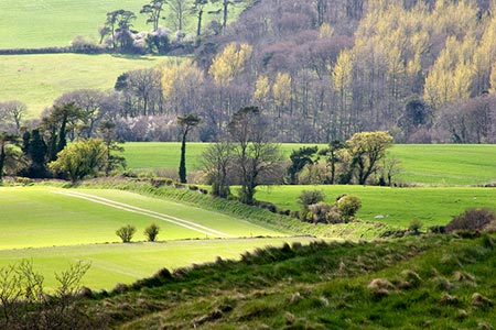
Click image to see photo description.
This Dorset walk starts from Loders and explores some wonderful scenery to the east of the village. A highlight of the route is the view from the site of an ancient hill fort on Eggardon Hill from where you can enjoy a superb panorama across the surrounding countryside. The walk also passes Mappercombe Manor which dates from the seventeenth century. It is recommended that you take the relevant OS 1:25k map.
Limited on street parking is available near the Loders Arms pub on New Street Lane (grid ref. SY494492). After parking walk along New Street Lane with the pub on your right. Reaching a road junction with a telephone box on the right, fork right to Uploders. At the next junction fork left staying on New Street Lane. Continue under the bridge to the end of the lane with a house on the right (grid ref. SY499940). Go straight ahead onto a bridleway and continue for 1.4 kilometres to reach Upton Manor Farm. Go through farm gates and continue straight ahead with most of the farm buildings on your left. Just past the last building, turn right onto the concrete farm access drive and follow it down to a road (grid ref. SY5159330).
At the road, turn left onto a track (signed footpath), Keep to the right of the buildings at the farm and follow path across a field with hedge on your right. Cross the stile and maintain direction to the far-right hand corner of the next field to reach Spyway Road. Turn left and almost immediately take the stile in the hedge on your right. Go half left up the field to a gate and a lane (grid ref. SY523932). Turn right along the lane and reaching a group of holiday cottages on the right, take the signed path down a driveway on the left. Continue past holiday lets into a field with hedge on your left. Near the end of the field go left and follow the path down to Spyway Road.
Turn right and walk past the Spyway Inn on your right. At the next junction, turn left up a drive (signed footpath). Continue to just before a farm and turn right at a fingerpost. Just before a gate, turn sharp right uphill. Then turn left through fence. After 400 metres fork right through some trees to a gate and road (grid ref. SY544939). Turn left along the road and after 350 metres take the signed path on the left through a wooden gate. Continue with fence to your left to a stile and enter the site of Eggardon Iron-age Fort. This is a perfect place to take a break as the view is wide-ranging.
From the stile you can either head straight across the fort, or alternatively bear left and follow the outline of the walls in a clockwise direction. Whichever way you explore, you need to head to the northern end of the fort and exit onto King's Lane. Turn left along the lane where it bends right (grid ref. SY536952) go straight ahead on a track. Go through several gates. Where the track bends sharp left, go ahead into the field and follow the path along side the right-hand hedge. Several stiles later you cross the old railway and continue down a field with hedge on your right to a stile (on your right). Continue up a drive to reach a lane (grid ref. SY520956).
Reaching a T-junction, turn right. Reaching the Marquis of Lorne, turn left down a track opposite the pub. After 500 metres turn left through a hedge and follow the path down the right-hand side of the field to a road. Go straight across following the waymarked path past a barn and to the right of Mappercombe Manor. After the Manor, bear right along a grassy track with hedge on your right. At the end of this large field, turn left with a small wood on your right, and continue down to join the old railway track bed. Turn right and continue through a Nature Reserve. Reaching the first bridge over a road (grid ref. NY496941), take the narrow path on the right down to the road below. Turn right and return to the start.
Maps 

| Ordnance Survey Explorer 117 | Sheet Map | 1:25k | BUY |
| Anquet OS Explorer 117 | Digital Map | 1:25k | BUY |
| Ordnance Survey Digital Map Subscription | |||
| Latest Ordnance Survey Discounts | |||
Other walks nearby
| Walk 3265 | Eggardon Hill from Powerstock | easy/mod | 6.3 miles |
| Walk 2391 | West Bay & Burton Cliff | easy | 4.5 miles |
| Walk 1549 | Golden Cap from Seatown | easy/mod | 4.0 miles |
| Walk 2494 | West Bexington & Abbotsbury Circular | moderate | 7.7 miles |
| Walk 2580 | Golden Cap & Charmouth | easy/mod | 5.0 miles |
| Walk 2565 | Littlebredy from Abbotsbury | moderate | 8.5 miles |
| Walk 2827 | Rodden & Langton Herring from Abbotsbury | easy/mod | 9.2 miles |
| Walk 2289 | Abbotsbury Castle and Chesil Beach | easy/mod | 6.0 miles |
| Walk 1551 | Seatown and Charmouth via Golden Cap | easy/mod | 5.0 miles |
| Walk 3523 | Abbotsbury & Portesham Circular | easy | 5.2 miles |
Recommended Books & eBooks
Walking the Jurassic Coast
 This guidebook includes 30 walks on the Jurassic Coast of Devon and Dorset. Covering the coast between Exmouth and Bournemouth, these delightful routes range from 3 to 16 miles (5 to 24km), exploring and explaining the spectacular geology of this World Heritage area with clear, easily understood descriptions, cross-sections and timelines.
More information
