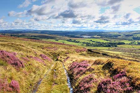
Dunsop Head from Slaidburn
Hill Walk + Moorland Walk + Pub Walk
Forest of Bowland Walk
Region - Forest of Bowland
County/Area - Lancashire
Author - Lou Johnson
Length - 7.0 miles / 11.4 km Ascent - 1000 feet / 303 metres
Time - 4 hours 30 minutes Grade - easy/mod
Walk Route Description
Click image to see photo description.
Starting from the attractive and historic village of Slaidburn, this walk explores the countryside and hills lying north of the village. The route includes woodland, open farmland, and moorland with fine views across the Forest of Bowland National Landscape.
The walk starts from Slaidburn car park located at the east end of the village on the banks of the River Hodder (grid ref. SD7145240. Exit the car park and turn right and walk up into the village. Reaching the junction by the Hark to Bounty Inn, continue ahead to reach a health centre on the right-hand side. Just past the building turn right over a stile into woodland. The path runs above Croasdale Beck on your right. Cross a ladder stile over a wall and continue through two gates at the edge of the wood. Entering a field keep to the left-hand edge. Cross a ladder stile and continue to a gate and a small stone footbridge. Cross the next field to a gap in the far corner. Continue beside a wall on your right and turn sharp right along an enclosed green lane to reach Myttons (grid ref. SD702535).
Turn left along a farm drive to reach a lane. Turn right and follow the lane which rises gently for 1.6 kilometres to reach a gate (grid ref. SD6925148). Pass through the gate and continue up a concrete track for 100 metres and turn sharp left at fingerpost to join a bridleway. After a section beside a wall, the rising track heads southwest across the flank of Dunsop Fell with a valley down to your left. As you make progress the track fades to a grassy path and soon levels off. Reaching a wall at Dunsop Head, turn left and follow the grassy path south with a wall on your left.
After 300 metres the path veers away from the wall and contours round the east side of Wisket Hill to reach a path junction (grid ref. SD679539). Fork left and follow an improving path east with the valley on your left. The onward route heads down the ridge towards a wall at Burn End. The path turns sharp right and continues down to a gate in the wall on your left. The path continues downhill to pass Burnside Cottage on your right. Once past the cottage the route follows an access drive past pools to reach a T-junction (grid ref. SD694530). Turn left and follow the lane back to Slaidburn, an easy walk of two kilometres.
Maps 

| Ordnance Survey Explorer OL41 | Sheet Map | 1:25k | BUY |
| Anquet OS Explorer OL41 | Digital Map | 1:25k | BUY |
| Ordnance Survey Digital Map Subscription | |||
| Latest Ordnance Survey Discounts | |||
Other walks nearby
| Walk 3730 | Stocks Reservoir Circular | easy/mod | 7.0 miles |
| Walk 3505 | Whitewell via Crag Stones from Dunsop Bridge | easy/mod | 8.5 miles |
| Walk 2508 | Dunsop Fell & the Forest of Bowland | moderate | 10.0 miles |
| Walk 2510 | Totridge Fell via Langden & Bleadale Water | mod/hard | 10.0 miles |
| Walk 2555 | Whitendale from Dunsop Bridge | moderate | 8.0 miles |
| Walk 2556 | Whitendale & Dunsop Fell from Dunsop Bridge | mod/hard | 15.0 miles |
| Walk 2331 | Whin Fell & Ouster Rake from Dunsop Bridge | moderate | 8.3 miles |
| Walk 2437 | Bowland Knotts | moderate | 7.4 miles |
| Walk 2594 | Totridge Fell & Fiendsdale Head, Forest of Bowland | moderate | 11.0 miles |
| Walk 2384 | Hodder Valley from Whitewell | easy/mod | 6.8 miles |
Recommended Books & eBooks
Walking in the Forest of Bowland and Pendle
 A guidebook to 40 diverse circular day walks suitable for walkers with navigational skills. The Forest of Bowland and Pendle are two of north west England's upland AONBs, perfect for walkers who enjoy exploring rough hilly, sometimes pathless terrain. The routes include Ward's Stone, Pendle Hill, Longridge Fell and Fair Snape Fell.
More information
Walking on the West Pennine Moors
 This guidebook describes 30 walks on the West Pennine Moors, around Blackburn, Darwen, Chorley and Bolton, home to some of the most inspiring and exhilarating walking country. The walks range from short, easy rambles to more challenging hikes covering a variety of terrain, all of it easily accessible for day walking.
More information
