Moulton & Gazeley Circular
Countryside Walk + Villages + Church
Suffolk Walk
County/Area - Suffolk
Author - Lou Johnson
Length - 6.7 miles / 10.9 km Ascent - 400 feet / 121 metres
Time - 3 hours 50 minutes Grade - easy
Walk Route Description
Click image to see photo description.
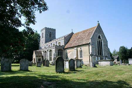
A circular walk from Moulton (Suffolk) exploring the rolling countryside west of the village. The route includes a section of Icknield Way, passes through the villages of Dalham and Gazeley, passes Dalham Hall and towards the end of the walk crosses a medieval packhorse bridge. Three fine churches are also passed including the largest church in West Suffolk at Gazeley.
The walk starts from The Street in Moulton where on-street parking is available near the post office (grid ref. TL696643). To start the walk and with your back to the post office, turn right and take the first signed footpath on the left. The fenced path soon crosses a footbridge over the River Kennett to reach a road. Turn right and keep ahead at the junction. Continue ahead to join a bridleway which runs beside the river on your right. Follow the clear track for two kilometres to reach a road (grid ref. TL713629).
Turn right, cross the river, and take the first signed footpath on the left into woodland. You are now following the Icknield Way. The path soon exits the trees and runs beside the river on your left. Cross a footbridge to reach a lane. Turn left into Dalham with thatched cottages on your right and a brick malting kiln on the left. Ignore a lane on the right and continue ahead to reach a signed footpath on the right. Pass through the gate and follow the path through an avenue of trees towards the grounds of Dalham Hall. Pass through a gate and turn right along Church Lane. Passing Dalham Church on your left. The lane soon forks. Bear left as indicated by the adjacent fingerpost (grid ref. TL725625).
After 250 metres turn left into woodland still following the Icknield Way. The path soon exits the trees and follows the right-hand field edge before turning left to enter Brick Kiln Wood. The path exits the trees and soon enters Blocksey Wood. The path follows the edge of the wood, turns right, and continues to a path junction (grid ref. TL734632). Turn left still following the Icknield Way. The path skirts the edge of Bluebutton Wood to cross fields to reach the rear of houses at Gazeley. An enclosed path runs between houses. Cross the cul-de-sac to a grassy open space opposite and bear left following a tarmac path which leads to a T-junction. Bear left along Higham Road to a T-junction with Gazeley Church opposite.
Cross the road and enter the churchyard (leaving the Icknield Way) and continue to a gate in the far corner. Join path enclosed by hedges. Cross a track and a tarmac drive and continue to Moulton Road (grid ref. TL713642). After 700 metres turn left over a waymarked stile partly hidden in a hedge. The path heads half-right across the field to a stile. Maintain direction downhill to a stile at the edge of a wood. Continue through the trees along a clear path to reach Moulton churchyard. Do not enter the churchyard but turn right. This path soon leads to gate by some barns. Continue ahead to reach Gazeley Road. Turn left towards Moulton. Reaching the fine medieval packhorse bridge keep ahead Bridge Street to a T-junction. Turn left and continue ahead for 200 metres to reach the post office and the start of the walk.
Maps 

| Ordnance Survey Explorer 210 | Sheet Map | 1:25k | BUY |
| Anquet OS Explorer 210 | Digital Map | 1:25k | BUY |
| Ordnance Survey Digital Map Subscription | |||
| Latest Ordnance Survey Discounts | |||
Other walks nearby
| Walk 2242 | Cavenham Heath and Lark Valley from Mildenhall | easy/mod | 7.8 miles |
| Walk 1938 | The Devil's Dyke from Reach | easy | 5.8 miles |
| Walk 3569 | Swaffham Prior & Devil's Dyke from Reach | easy/mod | 6.6 miles |
| Walk 2352 | Lode Mill, Quy Water & Quy Fen | easy | 4.2 miles |
| Walk 3263 | Clare and Cavendish Circular | easy/mod | 7.7 miles |
| Walk 1448 | Lavenham circular from Long Melford | easy/mod | 9.8 miles |
| Walk 1445 | Historic Long Melford | easy/mod | 8.0 miles |
| Walk 1446 | Sudbury circular from Long Melford | easy | 5.5 miles |
| Walk 3618 | Brent Eleigh from Lavenham | easy | 5.0 miles |
| Walk 3721 | Oakington and Longstanton round via Rampton Drift | easy | 6.0 miles |
Recommended Books & eBooks
Suffolk Coast and Heath Walks
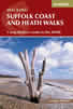 Guidebook to three long-distance routes exploring the varied landscapes of the Suffolk Coast and Heaths AONB. The Suffolk Coast Path covers 55 to 60 miles from Lowestoft to Felixstowe. The Stour and Orwell Walk is 40 miles from Felixstowe to Cattawade near Manningtree, while the Sandlings Walk is 59 miles from Ipswich to Southwold.
More information
