Siddington & Redes Mere Circular
Countryside Walk + Lakes
Cheshire Walk
County/Area - Cheshire
Author - Lou Johnson
Length - 4.2 miles / 6.8 km Ascent - 150 feet / 45 metres
Time - 2 hours 20 minutes Grade - easy
Walk Route Description
Click image to see photo description.
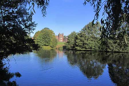
A short East Cheshire walk from near Siddington exploring woodland, meres, and countryside. The route follows paths, bridleways and lanes and offers views to Capesthorne Hall and across Redes Mere which is used by the sailing club.
The walk starts from the small parking area at the southern end of Redes Mere (grid ref. SJ849713) which can be reached from the A34. After parking, face the lake and turn left and continue to the A34. Cross carefully to the pavement opposite and turn right. After 200 metres turn left into Nursery Lane opposite a kitchen craft centre. Continue along the track soon reaching a house on the right. 100 metres past the house, turn right onto a bridleway. The grassy track runs beside woodland on your left and leads towards Blake House Farm.
After passing a house on the left, the track improves and continues to reach a farm access driveway. Turn left and continue to a lane (grid ref. SJ836716). Turn right along the lane and continue for 600 metres to reach a stile on the left. Ignore the stile and turn right through a hedge into a field. Turn left and follow the path keeping a hedge on your immediate left. The path runs parallel to the lane on your left and continues across fields to exit down steps on your left to the lane.
Turn right along the lane and immediately right again into Mill Lane. Continue across Hackneyplat Bridge and stay on the lane when it bends left. Continue ahead to the next junction with a mirror opposite. Bear right passing houses on your left. Stay on the lane for 250 metres to reach a gatehouse and drive on the left (grid ref. SJ 837725). Follow the gravel driveway towards a mere with Capesthorne Hall on the other side. Just before the bridge, bear right and follow a path along the edge of the mere. The path soon enters woodland and exits via a kissing gate onto the A34.
Cross the A34 with care to the signed footpath opposite. The path soon joins the access driveway for Redesmere Sailing Club. Turn right and continue past the clubhouse into woodland. After a few metres turn right and follow a path running parallel to woodland on your right. Continue across fields to a lane. Turn right back to the parking area.
Maps 

| Ordnance Survey Explorer 268 | Sheet Map | 1:25k | BUY |
| Anquet OS Explorer 268 | Digital Map | 1:25k | BUY |
| Ordnance Survey Digital Map Subscription | |||
| Latest Ordnance Survey Discounts | |||
Other walks nearby
| Walk 1371 | Rossendale Ramble from Sutton | moderate | 12.0 miles |
| Walk 2749 | Croker Hill Circular | easy | 4.0 miles |
| Walk 2605 | White Nancy & Saddle of Kerridge Nr Bollington | easy | 4.5 miles |
| Walk 2506 | Tegg's Nose from Trentabank | moderate | 7.5 miles |
| Walk 2535 | Wildboarclough & Shutlingsloe from Trentabank | moderate | 7.0 miles |
| Walk 1461 | Shutlingsloe from Trentabank | easy/mod | 3.0 miles |
| Walk 1502 | Shutlingsloe and Macclesfield Forest from Trentabank | moderate | 9.0 miles |
| Walk 3588 | Rainow Circular | easy/mod | 5.5 miles |
| Walk 2519 | The Cloud from Rushton Spencer | easy/mod | 9.0 miles |
| Walk 2604 | Dane Valley & Wincle from Rushton Spencer | moderate | 9.5 miles |
