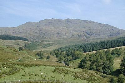
Rhobell Fawr from near Rhydymain
Snowdonia/Eryri Walk
Nat Park - Snowdonia - Arenigs
County/Area - Gwynedd
Author - Nick O'Brien
Length - 5.7 miles / 9.3 km Ascent - 1800 feet / 545 metres
Time - 4 hours 40 minutes Grade - moderate
Walk Route Description
Click image to visit gallery of 3 images.
This Snowdonia (Eryri) walk takes in the rarely visited summit of Rhobell Fawr. The start is reached by taking the A494 Bala to Dolgellau main road and turning north at a junction (grid ref. SH799216) marked Aran Hall School. Follow this lane past the School. At the next junction continue straight ahead, descend into a valley, cross a bridge following the road around to the right. Just before reaching a cattle grid there is spce for two carefully parked cars (grid ref. SH793224).
After parking continue up the lane. Where the lane bends sharp left continue ahead through the metal gate along a drive. Pass the house on the left and continue along the drive as it bends to the left ignoring the track on the right. Almost immediately turn right off the drive on a feint path between the trees to enter a field. Aim for the far corner and a gate. In the next field head half left. You will soon see Rhobell Fawr ahead with pine woods on either side. Continue to another gate after which a track leads beside the stream, Afon Melau. The track climbs steadily to the eastern corner (Grid ref SH786241) of a plantation that is on your left. Climb the stile and continue through the woods to reach a track.
Turn right along this track and head roughly north east. The OS 1:25000 map shows four walls crossing this track, two of which are encountered just after joining the track. Continue along the track to the fourth wall from the plantation (Grid ref SH791247). Turn north off the track and Follow this wall in northerly direction encountering a few short scrambles in a rocky landscape as you climb higher. Views to the Arans to the south and Cadair Idris open up as you gain height.
Following the wall up you reach a stile where you turn sharp left from where the trig point on Rhobell Fawr soon becomes visible. Climb over the stile to the top where the views are outstanding to the Rhinogs and north to Snowdon. From the summit head southwest over another stile following the wall until reaching another wall to the left which you follow down to the track. On reaching the track turn right and then retrace the route back to the start point.
As a variant stay on the track which soon swings south and continue to near Hafod-y-geifr (grid ref. SH785225) and turn left on a pathwhich leads to a track near Caer-Adda-wyn (grid ref. SH789228). Bear right along the track which leads back to the start.
This walk ascends an obviously seldom visited mountain which offers good climbing and superb views. It is the first time I have seen nobody else during a walk in Wales.
Maps 

| Ordnance Survey Explorer OL23 | Sheet Map | 1:25k | BUY |
| Anquet OS Explorer OL23 | Digital Map | 1:25k | BUY |
| Ordnance Survey Digital Map Subscription | |||
| Latest Ordnance Survey Discounts | |||
Other walks nearby
| Walk 2811 | Rhobell Fawr and Ddualt from near Rhydymain | moderate | 8.5 miles |
| Walk 1499 | Rhobell Fawr and Dduallt from Llanfachreth | moderate | 12.0 miles |
| Walk 2937 | Aran Fawddwy northern approach | mod/hard | 8.4 miles |
| Walk 1646 | The Precipice Walk | easy | 3.5 miles |
| Walk 2334 | The Torrent Walk near Dolgellau | easy | 1.6 miles |
| Walk 1107 | Waun Oer and Maesglase near Dinas Mawddwy | mod/hard | 11.0 miles |
| Walk 1190 | Aran Fawddwy | mod/hard | 7.5 miles |
| Walk 3055 | Glasgwm | moderate | 4.5 miles |
| Walk 1255 | The Aran Ridge | hard | 11.2 miles |
| Walk 1400 | The Arans | hard | 14.0 miles |
Recommended Books & eBooks
Mountain Walking in Snowdonia
 Guidebook to 40 of Snowdonia's best day walks, with routes up Snowdon and Tryfan, including the Snowdon Horseshoe, Cadair Idris, Y Garn and The Rhinogs. The routes range from Grade 1 scrambles like Crib Goch or Bristly Ridge, to riverside and forest walks. Includes details of a 2-day traverse of all 15 of Snowdonia's 3000ft peaks.
More information
Great Mountain Days in Snowdonia
 Inspirational guidebook to 40 great mountain day walks and scrambles in Snowdonia. Inspirational routes for all abilities across the National Park with routes up Snowdon and Moel Eilio, the Glyderau, the Carneddau, Eifionydd, Siabod and the Moelwynion, Rhinogydd (the Harlech Dome), Migneint and the Arans and Cadair Idris and the Tarrens.
More information
