Lyme Park from Poynton
Peak District Walk
Nat Park - Peak District - Goyt Valley Lyme Park
County/Area - Cheshire
Author - Mike Bexley
Length - 10.0 miles / 16.3 km Ascent - 1325 feet / 402 metres
Time - 6 hours 20 minutes Grade - moderate
Maps 

| Ordnance Survey Explorer OL1 | Sheet Map | 1:25k | BUY |
| Anquet OS Explorer OL1 | Digital Map | 1:25k | BUY |
| Ordnance Survey Explorer 268 | Sheet Map | 1:25k | BUY |
| Anquet OS Explorer 268 | Digital Map | 1:25k | BUY |
| Ordnance Survey Landranger 109 | Sheet Map | 1:50k | BUY |
| Anquet OS Landranger 109 | Digital Map | 1:50k | BUY |
Walk Route Description
Click image to see photo description.
This pleasant Peak District walk in Cheshire walk visits some of the countryside surrounding Lyme Park, which includes some wild moorland. Although the start is in Cheshire the majority of the route is within the boundaries of the Peak District National Park. Alternative shorter walks can be undertaken either by starting from the Lyme Park car park and picking the route up from The Cage path to the left of The Hall or using the 'Middlewood Way' or the canal as a link. These alternatives have the advantage of keeping the walk to the Outdoor Leisure sheet 1.
Start from the very small car park to the east of Poynton Lake (Grid ref. SJ925842). Exit the car park and turn left (north east) then right at the lane to head south. Continue along this lane turning left (Grid ref. 929840) to join a very wide path through the trees. This path was originally a colliery incline, whereby rail trucks transported coal to the canal for transhipment to narrow boats. The incline climbs east crossing a minor road then over a disused railway line, now converted to a bridleway named the 'Middlewood Way', ending at the Macclesfield Canal.
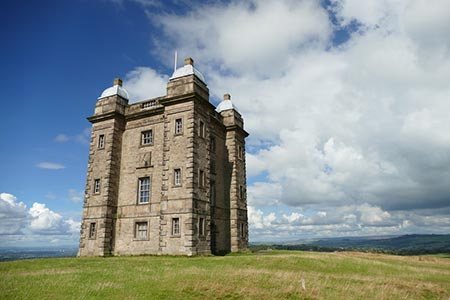
Turn right along the canal and cross to the other side at the next bridge. Here you take the footpath on the left keeping to the left of Barlow House Farm. From here head in a north-east direction up the fields turning left then right at the fences to Ryles Wood to continue to Elmerhurst Cottage (Grid ref. 963841). Go through the large gates into Lyme Park then immediately right to follow the pretty footpath through the woods. When the path nears the park-drive, you will see on the hill a tower named 'The Cage'. Make your way up the grassy hill to this building, which is thought to have been erected as a vantage point to watch stag hunting.
From The Cage head south on the wide mown path (not shown on maps) that keeps to the ridge and descends to the left of Lyme Hall (a National Trust property well worth a visit). Go through the farm type gate, keeping the hall and gardens on your right to follow the tractor track that in turn follows the Hampers Wood fence. Climb up hill until you reach the park boundary wall at grid reference 974821. This is a good area to see the red deer grazing below you.
Turn right and follow the wall until you reach Bowstonegate, the white building with its high radio masts that can be seen from miles away. If you want to see 'The Bowestones' turn left here as they are positioned near the road. A theory is these stones were used as a method of measuring the plumpness of sheep prior to their sale. Having viewed the stones retrace your steps then descend rapidly to the woods at Knights Low. Follow the wide path through the woods, then still loosing height, turn right after the woods to walk to the left of the car park. Take the tarmac surfaced road ahead of you, keeping the wall on your right. The surface changes to stones and leads you to the house and exit gate at Four Winds (Grid ref. 954827).
Follow the lane passing Haresteads Farm and Elm Wood down to the Canal Marina at Higher Poynton. Cross over the canal and the 'Middlewood Way' to reach the road. Walk down Anson Road opposite as far as the road junction (Grid ref. 935836). Cross over and walk up the bridleway. Just before the golf course turn left. This path leads you over Petre Bank passing behind a residential home to reach a bridle way opposite. This bridleway is another colliery incline and leads you down to the main Macclesfield Road. Turn right then right again back to your start.
Other walks nearby
| Walk 2329 | The Disley Lanes from Lyme Park | easy | 4.0 miles |
| Walk 1474 | Park Moor and Birchencliff from Lyme Park | easy/mod | 7.3 miles |
| Walk 1481 | Dale Top (Park Moor) from Lyme Park | easy | 6.3 miles |
| Walk 2523 | Black Rocks & Bollinhurst Reservoir | easy | 5.0 miles |
| Walk 2567 | Lyme Park & Dissop Head | easy | 6.0 miles |
| Walk 2528 | Kettleshulme & Sponds Hill | moderate | 8.0 miles |
| Walk 2605 | White Nancy & Saddle of Kerridge Nr Bollington | easy | 4.5 miles |
| Walk 2622 | Sett Valley & Kinder from New Mills | moderate | 10.0 miles |
| Walk 3588 | Rainow Circular | easy/mod | 5.5 miles |
| Walk 2546 | Lantern Pike & Cown Edge from Rowarth | easy/mod | 8.0 miles |
Recommended Books & eBooks
Walking in the Peak District - White Peak East
 Guidebook describing 42 half-day and day walks in the limestone landscapes of Derbyshire's White Peak, part of the Peak District National Park. One of two volumes, this book covers the east of the region, with potential bases including Bakewell, Eyam, Castleton, Birchover, Matlock and Wirksworth.
More information
Great Mountain Days in the Pennines
 An inspirational guidebook to 50 classic walks on the rolling Pennine landscape. The graded routes, between 6 and 13 miles in length, cover classic Pennine fells and moorland such as Whernside, Ilkley Moor and Pendle Hill; exploring the North and South Pennines, Yorkshire Dales, Howgills and Dark Peak. Many routes are also suited to fell running.
More information
Messaging & Social Media
Message Walking Britain and follow the latest news.

Mountain Weather
Stay safe on the mountains with detailed weather forecasts - for iOS devices or for Android devices.