Shining Tor & Goyt's Clough from Derbyshire Bridge
Peak District Walk
Nat Park - Peak District - Goyt Valley Lyme Park
County/Area - Derbyshire & Cheshire
Author - Lou Johnson
Length - 5.1 miles / 8.3 km Ascent - 900 feet / 273 metres
Time - 3 hours 30 minutes Grade - easy/mod
Walk Route Description
Click image to visit gallery of 9 images.
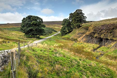
This Peak District walk visits Shining Tor, the highest point in Cheshire, before crossing heather moorland for a descent into Goyt's Clough and Derbyshire Bridge. The paths are easy to follow and the views excellent including Shutlingsloe (The Cheshire Matterhorn), Cat's Tor and Errwood Reservoir. There is a section of rough walking although this in descent and short. After heavy rain some sections of path may also be wet underfoot.
The start is the Derbyshire Bridge car park (grid ref. SK018715) where there are usually spaces even in fine weather. There are also public toilets. To reach the car park turn down from the A537 Buxton to Macclesfield Road near Tinker's Pit on Axe Edge Moor. Note that the lane running through Goyt's Clough north from the car park is one-way southbound.
After parking, exit the car park and follow the road uphill to reach the A537 at the Cat & Fiddle. This pub was closed in September 2017 and refreshments were available from a van parked in the lay-by opposite. Continue along the A537 towards Macclesfield using the wide verge. Where the A537 bends left, continue ahead onto a rough track (grid ref. SK000721). Follow this rising track taking the right fork after 250 metres. Continue the gentle ascent passing Stake Farm below on your left to reach a junction of paths and a gate (grid ref. SK000729). Take note of the footpath on the right as this will be sued later in the walk. Continue ahead through the gate and take the paved path on the left to reach the summit of Shining Tor (559 metres).
Allow time to enjoy the expansive view over Cheshire including the Cheshire Matterhorn (Shutlingsloe) and Lamaload Reservoir. To the north a long ridge extends to Cat's Tor and the Pym Chair. To the east views across the Goyt valley are excellent. To continue the walk, retrace your steps from the summit to reach the footpath junction at grid ref. SK000729). Turn left over either of the two stiles notes earlier and follow a clear path descending across the moorland. It is rough in places but not for long. The path soon reaches Stake Clough. After a brief ascent the path then briefly follows the edge of the plantation before passing through the trees.
Reaching a narrow wooden footbridge in Deep Clough (grid ref. SK011729) continue along the path through the trees. Ignore the path on the left descending to Goytsclough Quarry. The path soon leaves the plantation (grid ref. SK015727). The OS map shows a right of way contouring across the side of Goyt's Clough which meets the lane further up the valley. However, this can be very wet underfoot and a better option is to take the narrow path heading half left down to the road. All that remains is a steady uphill walk through Goyt's Clough over the Derbyshire Bridge and back to the start.
Maps 

| Ordnance Survey Explorer OL24 | Sheet Map | 1:25k | BUY |
| Anquet OS Explorer OL24 | Digital Map | 1:25k | BUY |
| Ordnance Survey Digital Map Subscription | |||
| Latest Ordnance Survey Discounts | |||
Other walks nearby
| Walk 1183 | Shining Tor & Axe Edge Moor | moderate | 9.0 miles |
| Walk 1652 | Three Shires Head | easy | 4.5 miles |
| Walk 2233 | Flash & Three Shires Head | easy/mod | 6.2 miles |
| Walk 2272 | Flash Circular from Cistern Clough | moderate | 8.0 miles |
| Walk 1092 | Taxal Edge, Jenkin Chapel & Pym Chair | moderate | 8.5 miles |
| Walk 2576 | Fernilee Reservoir, Goyt Valley | easy | 6.0 miles |
| Walk 3510 | Shining Tor, Cats Tor & Foxlow Edge | easy/mod | 7.0 miles |
| Walk 2577 | Hawk's Nest, Goldstitch Moss & Lud's Church | moderate | 8.0 miles |
| Walk 1596 | Lud's Church and Roach End from Gradbach | easy/mod | 4.5 miles |
| Walk 1598 | Lud's Church, Back Forest & Clough Head | easy/mod | 6.8 miles |
Recommended Books & eBooks
Dark Peak Walks
 Guidebook to 40 walks in the Dark Peak area of the Peak District National Park. 35 circular routes for most abilities, from 8km to 19km, around Edale, Marsden, Fairholmes, Baslow and Castleton, including Kinder Scout and Mam Tor, and 5 longer (25km to 45km) routes highlighting the best of the Gritstone Edges, High Moorland and Deep Valleys.
More information
Great Mountain Days in the Pennines
 An inspirational guidebook to 50 classic walks on the rolling Pennine landscape. The graded routes, between 6 and 13 miles in length, cover classic Pennine fells and moorland such as Whernside, Ilkley Moor and Pendle Hill; exploring the North and South Pennines, Yorkshire Dales, Howgills and Dark Peak. Many routes are also suited to fell running.
More information
