Upper Holme Valley & Ramsden Clough
South Pennines Walk
Nat Park - Peak District - Black Hill Dovestone
Region - South Pennines
County/Area - West Yorkshire
Author - Peter Schofield
Length - 9.0 miles / 14.6 km Ascent - 1600 feet / 485 metres
Time - 6 hours 10 minutes Grade - moderate
Walk Route Description
Click image to visit gallery of 4 images.
For many years, the delights of Ramsden Clough remained tantalisingly close but off limits to walkers in the Holme Valley. The introduction of the CRoW Act has now made this hidden gem available to all, and this circular Peak District walk provides a fine introduction to this part of the northern Peak District. Much of the walk is over paths not shown on the OL1 Dark Peak map, although one section may require use of a compass. Excellent bus links make this walk accessible to those without their own transport.
The walk starts in Holme village. From the village square (GR SE108060), go up Meal Hill Road past the school. The tarmac gives way to a long straight track, Issues Road which is followed for almost two kilometres as Black Hill looms ever larger ahead. At the track junction at GR089059, continue straight ahead on to the access land.
The track finally peters out on the bank of Issues Clough, but a path crosses the stream and continues up the hill on the opposite bank to join the Pennine Way at GR082057. From here, extensive views open out both to the east down the Holme Valley and to the north towards West Nab and the Wessenden Valley. Continue uphill along the familiar (and now extensively flagged) Pennine Way to the trig point at Black Hill.
From here, there is initially no obvious route to the next waypoint, the transmitter at Holme Moss. The easiest way to proceed is to take a bearing of 100 degrees and follow it across the peat for approximately 500m until the boundary fence is reached. Continue east along the fence to Heyden Head and cross the infant Heyden Brook, where a splendid panorama over Bleaklow opens out to the south.
On the far side, a fairly clear path contours along the east side of Heyden Brook and past the transmitter to reach a stile at GR095038. The path then turns left over boggy ground to reach the A6024 road at a lay by at GR096037. Turn left along the road and walk 200m to the car park on the opposite side. Cross over the access stile at the rear of the car park and go along a faint path to the brow of the hill from where there are extensive views over the Ramsden reservoirs and Holme Valley. Further east the transmitter at Emley Moor is a prominent landmark.
Although a path is shown on OL1 heading east from here towards Great Twizle Clough, it doesn't exist on the ground and should not be attempted. Instead follow the line of wall shown on the OS map contouring along Lightens Edge towards Great Twizle Head. The wall is mainly ruined but a clear path parallels it to Little Twizle Clough. As the clough is approached, drop down to the ruins of a hut a few metres below to the left at GR115036. It's a delightful place for a refreshment stop!
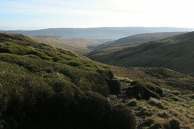
From the ruin, follow the path shown on OL1 across the boggy Herbage Hill to the ford at the head of Ramsden Clough. The clear path contours around the edge, revealing the wild beauty of the gorge, a truly hidden gem. The classic edge walk continues to grouse butts at the head of Ruddle Clough (GR126038) where the path from Snailsden Edge joins.
Turn sharp left to cross the stream at a post, continuing on the other side down a clear path. As the path levels out at a brow, look out for a path dropping steeply downhill to the corner of a copse at GR123041. From here, follow the path along the fence above the copse to reach a disused quarry from where a broad flat track heads below Ramsden Edge to join the Kirklees Way at GR119053. Turn left, following the Kirklees Way over Ramsden reservoir dam and Rake Dike to reach the A6024 at Holme. A left turn and 200m walk along the road returns you to the start at the end of a truly magnificent walk.
Holme is the terminus of First route 310 from Huddersfield and Holmfirth which operates hourly. In addition, route 61 runs from Glossop on Sundays and Bank Holidays. Full details can be found on the Metro website www.wymetro.com. Should you require sustenance, the Fleece pub can also be recommended for the excellent quality of both its food and beer. It's located on the main road 100m beyond the start.
Maps 

| Ordnance Survey Explorer OL1 | Sheet Map | 1:25k | BUY |
| Anquet OS Explorer OL1 | Digital Map | 1:25k | BUY |
| Ordnance Survey Digital Map Subscription | |||
| Latest Ordnance Survey Discounts | |||
Other walks nearby
| Walk 1829 | Holme & Marsden Clough from Ramsden Reservoir | moderate | 9.0 miles |
| Walk 1583 | Digley Reservoir | easy/mod | 5.0 miles |
| Walk 2561 | Digley & Ramsden Reservoirs from Wessenden Head | moderate | 9.5 miles |
| Walk 2518 | Black Hill & Four Reservoirs from near Wessenden Head | moderate | 10.0 miles |
| Walk 2719 | Huddersfield's green fringe | easy/mod | 10.0 miles |
| Walk 2826 | Winscar Reservoir Circular | moderate | 8.9 miles |
| Walk 3174 | Saltersbrook and Lady Cross from Woodhead | easy/mod | 6.0 miles |
| Walk 1756 | Bleaklow & The Longendale Trail from Woodhead | mod/hard | 10.0 miles |
| Walk 1586 | Blackmoorfoot Reservoir | easy | 1.5 miles |
| Walk 1179 | Lad's Leap & Laddow Rocks from Crowden | moderate | 6.5 miles |
Recommended Books & eBooks
Walking in the Peak District - White Peak East
 Guidebook describing 42 half-day and day walks in the limestone landscapes of Derbyshire's White Peak, part of the Peak District National Park. One of two volumes, this book covers the east of the region, with potential bases including Bakewell, Eyam, Castleton, Birchover, Matlock and Wirksworth.
More information
Great Mountain Days in the Pennines
 An inspirational guidebook to 50 classic walks on the rolling Pennine landscape. The graded routes, between 6 and 13 miles in length, cover classic Pennine fells and moorland such as Whernside, Ilkley Moor and Pendle Hill; exploring the North and South Pennines, Yorkshire Dales, Howgills and Dark Peak. Many routes are also suited to fell running.
More information
