Lad's Leap & Laddow Rocks from Crowden
Peak District Walk
Nat Park - Peak District - Black Hill Dovestone
County/Area - Derbyshire
Author - Lou Johnson
Length - 6.5 miles / 10.6 km Ascent - 960 feet / 291 metres
Time - 4 hours 10 minutes Grade - moderate
Walk Route Description
Click image to visit gallery of 4 images.
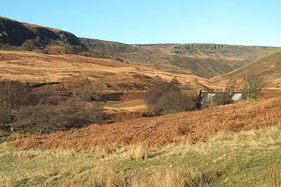
This Peak District walk starts at Crowden car park (grid ref. SK072992) on the north side of the busy A628 Manchester to Penistone road in Longendale. Leave the car park by the path that exits north to reach a track that heads west to cross a stream by a substantial bridge. On your left is a house (now a schools outdoor centre). There are many paths in the immediate area and providing an accurate description is almost impossible. However you need to head uphill in the general direction of Lad's Leap (grid ref. 053998). After a short way it becomes more obvious which path to follow. Climbing steadily you leave the traffic noise behind and able to enjoy the ever improving view in peace and quiet.
Soon the path levels off and you have completed most of the ascent for this walk. To the south are excellent views across Longendale, with its many reservoirs, to the Bleaklow plateau with its well defined northern edges. Continuing westwards you reach Lad's Leap, which is a deep rocky clough cut into the moor. Apart from the difficulties in navigating the maze of paths at the beginning of the walk, the going has been easy. this is about to change.
Ideally the next section of the walk should be left for a day after a heavy overnight frost or when there has been a long period of dry weather. if neither of these conditions apply you can be sure the going will be soggy as you cross Rakes Moss. Leaving Lad's Leap head for Rakes Rocks, which are over the horizon. Carefully picking a way across the deep peat of the moor, you are advised to follow a compass bearing. This is easier said than done and in good visibility it is easier to walk north-north-east picking the driest route across the peat.
In winter this area is well known for the large white hares that suddenly appear and you can be excused for thinking you might be in Alice's Wonderland until the initial shock has passed. Reaching Rakes Rocks contour around the moor, negotiating the deeply incised Oaken Clough to reach the Pennine Way. Continue north on Britain's first long-distance footpath as it follows the edge of Laddow Rocks with a precipitous drop to your right. This is a spectacular section of the walk with extensive views in all directions.
As you begin to descend keep a watchful eye on the path running parallel to the Pennine Way below you in the valley. This is your return route and at grid reference 061025 you need to turn around at an indistinct junction to follow the lower path as it skirts along the base of Laddow Rocks. Heading south the return route is easy to follow although it seems longer than it really is back to Crowden car park.
Maps 

| Ordnance Survey Explorer OL1 | Sheet Map | 1:25k | BUY |
| Anquet OS Explorer OL1 | Digital Map | 1:25k | BUY |
| Ordnance Survey Digital Map Subscription | |||
| Latest Ordnance Survey Discounts | |||
Other walks nearby
| Walk 2625 | Torside Clough from Longdendale | moderate | 4.5 miles |
| Walk 3027 | Bleaklow Head from Longdendale | moderate | 8.0 miles |
| Walk 3174 | Saltersbrook and Lady Cross from Woodhead | easy/mod | 6.0 miles |
| Walk 1756 | Bleaklow & The Longendale Trail from Woodhead | mod/hard | 10.0 miles |
| Walk 1168 | Old Glossop & Bleaklow | moderate | 9.5 miles |
| Walk 3607 | Reservoirs Walk from Tintwistle | easy/mod | 5.5 miles |
| Walk 1759 | Torside Clough & Longendale from Old Glossop | moderate | 7.4 miles |
| Walk 1703 | Longdendale from Hadfield Station | easy/mod | 9.0 miles |
| Walk 2517 | Chew Reservoir & Fox Stone from Dovestones | moderate | 7.5 miles |
| Walk 2553 | Greenfield Reservoir & Raven Stones from Dovestone | moderate | 8.0 miles |
Recommended Books & eBooks
Dark Peak Walks
 Guidebook to 40 walks in the Dark Peak area of the Peak District National Park. 35 circular routes for most abilities, from 8km to 19km, around Edale, Marsden, Fairholmes, Baslow and Castleton, including Kinder Scout and Mam Tor, and 5 longer (25km to 45km) routes highlighting the best of the Gritstone Edges, High Moorland and Deep Valleys.
More information
Walking in the Peak District - White Peak East
 Guidebook describing 42 half-day and day walks in the limestone landscapes of Derbyshire's White Peak, part of the Peak District National Park. One of two volumes, this book covers the east of the region, with potential bases including Bakewell, Eyam, Castleton, Birchover, Matlock and Wirksworth.
More information
