Great Horwood & Adstock circular
Buckinghamshire Walk
County/Area - Buckinghamshire - North Buckinghamshire
Author - Allan Friswell
Length - 5.5 miles / 8.9 km Ascent - 200 feet / 61 metres
Time - 3 hours 0 minutes Grade - easy
Walk Route Description
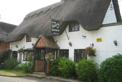
Click image to visit gallery of 2 images.
Set off the beaten track, Adstock remains a quiet and very attractive village with a number of thatched cottages and appealing Victorian buildings. The church of St Cecilia dates from the 12th century, and the doorway and three feet thick interior lower walls bear witness to the Norman origins. It is an intimate, almost cosy little church. The mid 17th century Old Thatched Inn is just that, with a flagstone floor and low but very spacious interior. There is a non-smoking area in the restaurant. Beers on offer are Hook Norton, Ruddles Best and County. There is a garden with children's play facilities. The pub has a large car park but do seek the landlord's permission before parking.
How to get there: follow the A413 from Buckingham to Winslow. Approximately 1/4 mile after Padbury turn left to Adstock - the pub is on the left at the far end of the village (Grid ref. SP 736302).
The Walk: From the pub, turn right and go down Main Street and turn left along East Street. Go downhill between two thatched cottages, that on the left being typical Bucks wychert construction. (Wychert is the local name for earth walling. On a plinth of rubblestone, the local subsoil, wetted and mixed with chopped straw is built up in two foot layers to the required height). Continue straight ahead into The Gardens. Take the footpath on the right by the power pole.
The next stile is clearly visible on the left. Cross the field going half-right to the stile. Both fields show clear evidence of Saxon ridge and furrow cultivation. Cross to a clump of trees in the right-hand corner - the stile is 50 yards to the right of a white gate in the hedgerow ahead. Follow the little track to the right. Over the stile and then a second in the middle of the left hand hedge.
Bear half-right, crossing to the track. Turn left at the road and, passing the farmhouses, take the gate at the start of the track on the right. The next stile is across the field about 25 yards to the left of a lone tree. Keeping the hedge on your right follow the field's edge round the corner to the left, past a gap where a gate used to be, to the far corner.
Here you need to go right to a group of conifers, and then immediately left, crossing the field straight ahead to the bridge and twin stiles. A solitary tree gazes at you from your left as you cross. In the next field make for the metal gate and a footbridge half right. After crossing the bridge, turn sharp left, and keep the hedge and brook on your left as you take the long route to the far corner. After the kissing gate make for another opposite, keeping in line with a distant pylon.
Cross the next field keeping the steeple of St James, Great Horwood, ahead of you. Go over the metalled lane, twin stiles and the next field, keeping the power pole close on your right hand. Go over the stile and cross the slight incline bearing half left to the collapsed tree in the far hedgerow. Turn left to the corner of the field and negotiate a bridge and stile. (You may wish simply to make straight for the corner).
Climb the field walking in line with the church ahead, keeping the buildings of Deans Farm well to your left. Over a triple stile next to an ivy-covered tree and cross the field. At the lane turn right and walk into Great Horwood. Turn right at the Swan, a fine pub with Charles Wells and Greene King IPA on draught, and serving good food. There's also a games room and a very pleasant garden. Descend the hill and take the right hand footpath via a gate.
Cross to the far left hand corner keeping in line with another distant pylon. Keeping the brook on your left, hug the edge of three fields, ignoring the tempting footbridge of the North Bucks Way (Grid ref. SP 764305). Eventually, reaching a plank bridge after passing under power cables, you veer half right across the field with your back to the bridge. This crossing seems to go on forever!
You finally arrive at a waymarked bridge and stile, often overgrown. Negotiating these, bear half-left ahead. Cross the grassy bridge and head to the gate opposite. Adstock church is ahead just to your right. The gate, sadly, is always locked, but climb it - it IS your right of way that's being blocked! Ahead are three white gates and your twin stiles are next to the middle one. Walk down the middle of a long narrow meadow to the white gate and stiles ahead. Cross the next field to the stiles 25 yards to the right of the white gate. Turn left between an escort of trees, cross the final stile. Go up the lane to the phone box; turn right and so back to the pub.
Maps 

| Ordnance Survey Explorer 192 | Sheet Map | 1:25k | BUY |
| Anquet OS Explorer 192 | Digital Map | 1:25k | BUY |
| Ordnance Survey Digital Map Subscription | |||
| Latest Ordnance Survey Discounts | |||
Other walks nearby
| Walk 2968 | Hillesden from Steeple Claydon | easy | 4.5 miles |
| Walk 3314 | Akeley & Maids Moreton | easy/mod | 7.0 miles |
| Walk 3361 | Chackmore Circular | easy | 4.0 miles |
| Walk 3244 | Stowe Park from Chackmore | easy | 4.3 miles |
| Walk 2490 | Quainton & North Marston Circular | easy/mod | 6.8 miles |
| Walk 2628 | Charndon & Edgcott | easy | 6.0 miles |
| Walk 2396 | Finmere & Westbury | easy/mod | 6.1 miles |
| Walk 2389 | Wing & Cublington Circular | easy/mod | 8.0 miles |
| Walk 1816 | Old Linslade Circular | easy/mod | 9.0 miles |
| Walk 3669 | Grand Union Canal - Aylesbury to Wendover | moderate | 11.7 miles |
