The Marcle Ridge from Much Marcle
Herefordshire Walk
County/Area - Herefordshire
Author - Allan Friswell
Length - 7.0 miles / 11.4 km Ascent - 700 feet / 212 metres
Time - 4 hours 10 minutes Grade - easy/mod
Walk Route Description
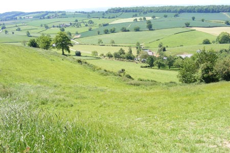
Click image to visit gallery of 6 images.
This walk takes you along the crest of Marcle Ridge with views of the distant Malverns, and through grass meadows full of clovers and buttercups in early June. The climb from Kynaston to Marcle Ridge is about 400 feet, and provides the only real effort in an otherwise easy-paced ramble, though you may find the stiles and bridges on the outward leg to Kynaston covered in vegetation. Much Marcle church is very much worth a visit.
To reach this little village from Hereford take the A438 east to Trumpet and its eponymous pub, turn right along the roman road, then right at the roundabout along the A449. Park with consideration near the village centre. From here go down the right-hand side of the village garage (housed in a former WW1 hangar), through the yard and through the gate to Hereford Model Club. Turn right and follow the hedgerow on your right passing the Model Club's HQ. Cross the bridge at the end of this field and in the next field look for the stile on your right towards the end of the field. Cross the stile then a small footbridge and a further stile into the field. Turn left and very shortly a footbridge with stiles will be found on your left (grid ref. SO655340).
Cross this and continue straight ahead with the hedge on your left into the corner of the field. Now turn right, still following the hedge on your left. Towards the end of the field a footbridge with stiles is on your left (grid ref. SO653343). Cross these and turn right and head for the right hand corner of the field. Look for a small plank bridge with a stile leading into the next field. Turn right, making for the stiles and footbridge ahead. Then follow the hedge on your left looking for a footbridge with stiles on your left (grid ref. SO652346). Cross this and then turn half-right to go across the open field to stiles and sagging footbridge (grid ref. SO651348). Cross this and follow the hedge on your left. Continue along the same line in the next field and then cross the stile in the fence into the left-hand field (grid ref. SO648353).
Go across the field to a footbridge and follow the same line through the next two fields to the lane, exiting via the gate. Turn right along the lane till another lane joins from the left. Turn left up this lane passing Wall House and then at the t-junction turn right. At Little Hall the track bears sharp left and starts the increasingly steep climb up to Marcle Hill. Follow the track uphill to the t-junction with the bridleway, turn left and descend slightly to reach the lane at Hooper's Oak. Go forward along the road for almost a kilometre to the fork in the road (where the grandly designated picnic site, in reality a small car park, is situated down the right-hand track at grid ref. SO630646).
Just along the left-hand fork, steps lead up to a stile, passing behind the picnic site. Follow the fence/hedgerow on your right along Marcle Ridge and part of the Herefordshire Trail. Here, you can enjoy views of the Malvern Hills to the left. Walk on along the ridge past the TV mast until you drop down to cross a stile out on to a track (grid ref. SO630328). Turn left along the track till you reach the junction with the lane. Continue straight ahead down the lane. After the house Upper Nuttall, turn right down the track till you come to the gate to Little Puckmore, where you cross the stile via the path to the left of the gatepost.
Follow the hedgerow on your left around two sides of the field to a stile (grid ref. SO640326) in the far corner. Cross this and follow the hedge on your right to find a stile on your right, which leads out on to the track. Follow this track down to the lane, ignoring the footpath which goes off to the left. At the lane go straight across to the gate opposite and then continue across the field at 10 o'clock aiming for an obvious stile by the large trees ahead of you (grid ref. SO643324). Cross the stile out into the lane and go through the gateway opposite. Follow the hedge on your right and when you enter the next field continue on the same line to a footbridge.
Again continue on the same heading to reach a stile on the side of the A449. Cross this with care and go through the small gate and over the footbridge opposite. Walk through the meadow, ablaze with buttercups in early summer, up to the gate leading into Much Marcle churchyard. In front of the church is reputedly one of the oldest yew trees in the country, variously dated between 1000 and 1500 years old. It now has a hollow trunk, into which a small bench has been added, ideal for eating lunch in, when there is inclement weather about. The building itself contains many features of interest, including a beautifully preserved wooden figurine, a great rarity in this country, one of only two in the county; the tomb of Blanch Mortimer, whom Simon Jenkins, in his book "England's Thousand Best Churches" describes as having "an image as lovely as any bequeathed us by a medieval church" and refers to her as Much Marcle's 'sleeping beauty'; and six carved Green Men. Continue on through the churchyard to join the B4024, turn left and walk through Much Marcle to the centre.
Maps 

| Ordnance Survey Explorer 189 | Sheet Map | 1:25k | BUY |
| Anquet OS Explorer 189 | Digital Map | 1:25k | BUY |
| Ordnance Survey Digital Map Subscription | |||
| Latest Ordnance Survey Discounts | |||
Other walks nearby
| Walk 1870 | Dymock Daffodil Walk | easy/mod | 9.0 miles |
| Walk 2192 | Wye Valley Walk | easy/mod | 6.6 miles |
| Walk 2365 | Mordiford & Hampton Bishop Circular | easy/mod | 7.6 miles |
| Walk 2326 | Herefordshire Beacon from Hollybush | easy/mod | 6.5 miles |
| Walk 1516 | Pershore Circular | easy/mod | 8.3 miles |
| Walk 2380 | The Malverns from the Gullet | moderate | 12.0 miles |
| Walk 2664 | Herefordshire Beacon from British Camp car park | easy | 2.0 miles |
| Walk 1211 | The Worcestershire Beacon | easy/mod | 4.5 miles |
| Walk 2751 | Goodrich Circular | easy/mod | 6.5 miles |
| Walk 2483 | Cradley Circular | easy/mod | 6.0 miles |
