Walk 2821 - printer friendly version
Melynllyn & Dulyn Reservoir from Llyn Eigiau parking Walk
Author - Lou Johnson
Length - 5.5 miles / 8.9 km
Ascent - 900 feet / 273 metres
Grade - easy/mod
Start - OS grid reference SH731662
Lat 53.1777260 + Long -3.9002186
Postcode LL32 8SH (approx. location only)
The Carneddau Mountains form the largest area of high ground in England and Wales rising to over 3000 feet above sea level. This walk does not visit any of the peaks in the range but still captures the flavour of the wild country in this part of Snowdonia (Eryri). The outward half of the route is easy to follow but some navigational skills are required for the return. Suitable boots are needed and there are no refreshment opportunities. Also be prepared for rapid changes in the weather.
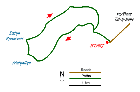
The start of this Snowdonia (Eryri) walk is the small parking area for Llyn Eigiau (grid ref. SH731662), which is reached by a narrow lane from Tal-y-bont on the B5106 Conway to Betws-y-coed road. After parking take the clear track heading north-west. Cross the stile and take the track past the sheepfold (grid ref. SH725667). Continue along this track as it climbs around the northern flank of Clogwynyreryr to enter a broad valley. The track continues climbing and after just under two miles you pass a ruin (grid ref. SH706656) where the track bends right and heads north-west to the corner of Melynllyn Reservoir.
From here a clear path heads north down to the shores of Dulyn Reservoir, which like Melynllyn has a backdrop of impressive crags. From here take the footpath on the north side of the valley (Pant y Griafolen) for about a mile and a quarter to cross Afon Garreg-wen at grid ref. SH717675. Turn right just after this point heading almost due east walking downhill towards a dam. You will near to cross the Afon Dulyn below the dam. Choose the shallowest point as there is no bridge. Pick up the track on the other side and continue to the derelict farm of Maeneira (grid ref. SH727673).
From here continue south along a clear path/track to rejoin the outward route at a sheepfold. Cross the stile and head southeast along the track back to the start.
Messaging & Social Media
Message Walking Britain and follow the latest news.

Mountain Weather
Stay safe on the mountains with detailed weather forecasts - for iOS devices or for Android devices.