Ayot St Lawrence to Ayot St Peter Circular
Hertfordshire Walk
County/Area - Hertfordshire
Author - Elaine and Craig Hindal
Length - 4.6 miles / 7.5 km Ascent - 300 feet / 91 metres
Time - 2 hours 40 minutes Grade - easy
Maps 

| Ordnance Survey Explorer 182 | Sheet Map | 1:25k | BUY |
| Anquet OS Explorer 182 | Digital Map | 1:25k | BUY |
Walk Route Description
Click image to see photo description.
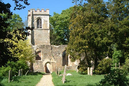
There are several walks from Ayot St Lawrence, a small village best known as the home of George Bernard Shaw, where his house, Shaw's Corner, is maintained by the National Trust and open to the public Wednesdays through Sundays, April through October. Roadside parking is available near the ruins of The Church of St Lawrence (Grid Reference TL194168), which is easily visible from the road, although parking can be very limited at weekends when the local pub, the Brocket Arms, is quite busy. At Saturdays and Sundays, it's best to plan an early walk so that you can park without any problem.
With the pub, The Brocket Arms, behind you, turn right out of Ayot St Lawrence, turning right again at the signpost to Ayot St Peter. Where the road bends sharply to the right (at Grid Reference TL198166), take the footpath on your left through the gap in the hedge and up a short bank onto open fields. Follow the path ahead up the hill. You will come to a cross-roads where the path crosses a farm access track (you will see Hill Farm to your right). Carry on straight ahead.
The path reaches a narrow country road (Codicote Road). Taking care, cross the road as the path continues straight in front of you. Follow the path as it goes up hill a little (but it's not steep) and follow the path as it bends to the right by an old tree and follows a short hedge on your left.
At the top of the small hill, one path leads diagonally across the field to the left; but you are going to go straight ahead on the wider path that leads towards and around a small, rather sunken copse of trees. Follow the path around this and you will reach the road at a black and white cottage, and directly opposite the old cemetery of Ayot St Peter.
Turning left, follow the country lane into Ayot St Peter. Before reaching the Church, however, you will take the path on your right signposted to Waterend (just before School Lane on your left and a sign pointing to Welwyn and Codicote) and walk alongside a small private wood, Saul's Wood. After walking alongside the wood, you will arrive at Ayot Greenway, a former railway line and now a broad and comfortable path (and an excellent cycle trail). Turn right along the Ayot Greenway.
After a while, you will arrive at an old bridge named on the OS map at Grid Reference TL206143 as Hunters Bridge (but we could find no sign bearing this name). Descend from the Greenway but do not go under the bridge, and instead follow the path up as it goes slightly to the left. There will be a small coppiced wood to your left, and an area of pine trees to your right; further on, the woods (Dowdell's Wood) are only to your right.
You will soon reach Codicote Road again. Taking care, cross the road to the path opposite and carry straight on. Stocking Springs, a small and rather lovely nature reserve of coppiced hornbeam trees, is immediately to your right. You can walk through the nature reserve and re-join the bridleway through a small gate at the top.
The bridleway will bring you to the road (Grid Reference TL194165). Turn right here and walk up the road back towards Ayot St Lawrence, passing Shaw's Corner, with the entrance to the house and gardens on the left. Continue up the road to where our walk started.
In the nearby area
It is worth a small detour to visit St Peter's Church, the spire of which can be seen from the path as you enter Ayot St Peter. It is an "arts and crafts" church, designed by J.P. Seddon and built in 1875 after the original church (at the site of the cemetery passed earlier on the walk) burnt down after being struck by lightning on 12th July 1874. There has, apparently, been a Church of St Peters in this vicinity since 1282. Information from British History.
Practical information
There are some benches along Ayot Greenway which make a nice place to enjoy the view or have a packed lunch. Also, Hunters Bridge on the Ayot Greenway is a good place to shelter if you need to escape the rain!
How to get to Ayot St Lawrence
The village is accessed by minor roads including single track with passing places. One way is to take the B197 on the west side of Welwyn Garden City and then follow the signs to Ayot Green, then Ayot St Peter and finally Ayot St Lawrence.
Note - Shaw's Corner is owned and managed by the National Trust and is open to the general public. Opening times are - House 17th March-28th October 1.00 pm - 5.00 pm not Mondays or Tuesdays (except Bank Holidays) Garden - as house, but 12.00 - 5.30 pm with last entry 4.30 pm. A visitor's car park is close by, within the grounds. For more information visit the National Trust website.
Other walks nearby
| Walk 1532 | Wheathampstead circular | easy | 4.5 miles |
| Walk 2799 | Ayot Green Circular | easy | 4.3 miles |
| Walk 2945 | Lea Valley from Batford to Mill Green | easy/mod | 8.5 miles |
| Walk 2221 | Circular from St Paul's Walden to Little Almshoe | easy/mod | 7.0 miles |
| Walk 2708 | Cuckolds Cross & Whitwell from St Paul's Walden | easy/mod | 7.0 miles |
| Walk 1139 | St Albans via Redbournbury Watermill from Harpenden | moderate | 12.0 miles |
| Walk 2457 | Stanborough Park, Welwyn Garden City | easy | 2.0 miles |
| Walk 1022 | Sandridge Circular | easy | 4.0 miles |
| Walk 1607 | Sandridge, Coleman Green & Brocket Hall Circular | easy/mod | 9.0 miles |
| Walk 2441 | Lea Valley from Mill Green to Ware | easy/mod | 9.5 miles |
Recommended Books & eBooks
No suggestions for this area.Messaging & Social Media
Message Walking Britain and follow the latest news.

Mountain Weather
Stay safe on the mountains with detailed weather forecasts - for iOS devices or for Android devices.