Wheathampstead circular
Hertfordshire Walk
County/Area - Hertfordshire
Author - Barry Mackie
Length - 4.5 miles / 7.3 km Ascent - 400 feet / 121 metres
Time - 2 hours 40 minutes Grade - easy
Walk Route Description
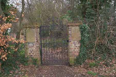
Click image to visit gallery of 9 images.
If you want to see the site of an ancient battlefield, walk through a Devil's Dyke, visit an unusual almost hidden association with a true giant of both English Literature and the Church; and do all this whilst taking a stroll alongside Hertfordshire's largest river, crossing two fords and sharing tracks with two of the longest footpaths in the county, then this is the one to do. As interesting as a walk in the Hertfordshire countryside possibly can be, there is also a final enticement; it starts and finishes at a pub with another passed on the way!
Situated between the towns of Harpenden and Welwyn Garden City, Wheathampstead is accessed via the B653 and free roadside parking is available in the vicinity of the Nelson pub (Grid ref TL184137) in Marford Road, or possibly in Dyke Lane at the entrance to the Devil's Dyke. From the Nelson pub, cross the road and follow the distinctive waymarker, with a stags head as the emblem of the Hertfordshire Way, south along Dyke Lane for a short distance to reach the entrance on the left side to the Devil's Dyke.
Here on the brick pillars are two stone plaques, one which identifies this place as the likely site of battle between the English and the Roman armies in 54 B.C, and also that the dyke formed part of an ancient city. Go through the gate and follow the path for some 250m through the Devil's Dyke, essentially a man made ditch, 12m deep in places and probably constructed during the Iron Age.
Leave the Dyke at its southern end and come back out onto the road either via the woods or by walking alongside the edge of the field, and continue along the road to reach the entrance to Beech Hyde Farm.
Turn left here and walk down the footpath on the farm track in a south easterly direction to reach the sharp bends of the minor road (Grid ref TL185128). Continue along the road for a few metres to enter the field and head across it to the woods at the far side, again in a south easterly direction.
Maintain direction on the path through the woods to come out on the shingle drive alongside the buildings and bear left to reach the road and the tiny village of Coleman Green. To your left is the John Bunyan pub and with plenty of outdoor seating available, this is a good place to stop for a break.
Go past the pub and cross the old Roman Road to the footpath signposted to the Marford Road. Before you take this path though, go through the gate to the left to enter the small area containing "John Bunyan's Chimney", which is part of a cottage that once stood on the site. An excellent information board close by, tells you all you need to know about this charming little place and its links to the man who wrote The Pilgrim's Progress.
Leaving here, follow the path in an east/north easterly between the trees and banks to reach the Marford Road. Most of this section is below the level of the fields on either side and in wet weather this is the watercourse. If it is boggy, then you can come off the path and walk along the edge of the field to your right.
On reaching Marford Road take the path to your left to come up to the level of the road and cross the road and turn right along the verge to reach the large lay by some 100 metres further along. Enter the lay by, and at the middle point go left through the gap in the fence and follow the path in a northerly direction down the slope to reach the bridge over the River Lea, Hertfordshire's largest river.
At the centre of the crossing is a rather unusual semi derelict building with a flint and rendered finish and some elaborate brickwork. There are no information boards or clues as to what its purpose was, and the OS map merely describes the location as Flint Bridge. Cross the bridge and walk to the edge of the woods a short distance away and turn left alongside the fence to follow the line of the river through the fields, in a north westerly direction. This next section of the route is on the second of the long distance paths travelled on during this walk, and is The Lea Valley Walk, a 50 mile trail between Luton and East London. Look out for its waymarker which is a white swan on a green background.
After 500 metres the route comes out next to the ford on Waterend Road. Turn right, away from the ford and walk up the road a few metres to meet the continuation of the path. Pause to admire the magnificent house just to the right, and if this walk has a theme, then it has to be chimneys, of which there are some superb examples here!
The path continues close to, or alongside the river for another 2 kms to arrive at the gap in the wooden fence by the roadside of (Cory-Wright Way). Turn right alongside the fence to reach the steps cut into the bank leading down to the unmade track and the bridge under the road (grid ref TL185141). Take this route in a southerly direction to cross the river at the ford, and then continue into Sheepcote Lane, alongside some houses. Walk up the slope to the main road and with the Nelson pub on your right, you are back to the start point.
Maps 

| Ordnance Survey Explorer 182 | Sheet Map | 1:25k | BUY |
| Anquet OS Explorer 182 | Digital Map | 1:25k | BUY |
| Ordnance Survey Digital Map Subscription | |||
| Latest Ordnance Survey Discounts | |||
Other walks nearby
| Walk 1372 | Ayot St Lawrence Circular | easy | 6.0 miles |
| Walk 2338 | The Upper Mimram Valley | easy | 5.7 miles |
| Walk 2944 | Ayot St Lawrence to Ayot St Peter Circular | easy | 4.6 miles |
| Walk 1022 | Sandridge Circular | easy | 4.0 miles |
| Walk 1607 | Sandridge, Coleman Green & Brocket Hall Circular | easy/mod | 9.0 miles |
| Walk 2799 | Ayot Green Circular | easy | 4.3 miles |
| Walk 2945 | Lea Valley from Batford to Mill Green | easy/mod | 8.5 miles |
| Walk 1139 | St Albans via Redbournbury Watermill from Harpenden | moderate | 12.0 miles |
| Walk 2457 | Stanborough Park, Welwyn Garden City | easy | 2.0 miles |
| Walk 1122 | St Albans & Childwick Green | easy | 4.0 miles |
