Circular from St Paul's Walden to Little Almshoe
Hertfordshire Walk
County/Area - Hertfordshire
Author - Donald Morton
Length - 7.0 miles / 11.4 km Ascent - 500 feet / 152 metres
Time - 4 hours 0 minutes Grade - easy/mod
Walk Route Description
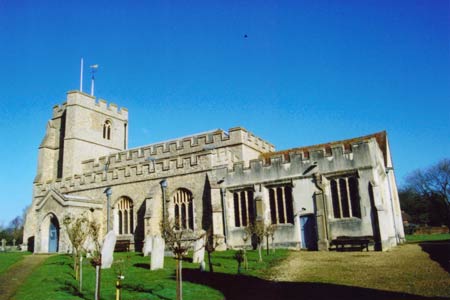
Click image to visit gallery of 5 images.
St Paul's Walden is now a small hamlet on the B651 between Whitwell and Hitchin. It has associations with Queen Elizabeth, the Queen Mother, who was born at the Bury just north of Whitwell which, although now a much larger village, is within the parish. The church itself (where the Queen Mother was baptised in 1900) dates from the 14th Century and is notable for an English Baroque chancel. It can be reached by turning off the B651 up the side of the Strathmore Arms PH. The walk starts from the parking place opposite the church (Grid Ref TL 193 222).
The first part is on the Hertfordshire Way. Go through the churchyard and, passing the east end of the church, exit through a gate to cross a lane and go down a track by the side of the White House. Just past this turn right down a footpath signed as the Chiltern Way Extension along an enclosed path and then a field edge, fence right. This comes out onto the B651. Do NOT take the footpath opposite but turn left and walk along the road (CARE!) about 200 metres past the entrance to Stagenhoe to a footpath going right. Take this wide path through woods. On emerging go straight on over pasture to join a hedge. At a waymark post go through a fence gap and straight across a wide open field on to woodland ahead.
Cross a lane and go straight on down a strip of woodland. On emerging turn left along a field edge, hedge left, and follow the broad track to the field corner. Here go straight on past a stile to a lane corner. Go straight on past Clifton House and down a bridleway (still Chiltern Way Extension). Where this forks go right down to the B651. Cross over on a right diagonal to continue on a bridleway along the field edge, hedge and B651 right. After about 100yds (no waymarks) fork left heading up to the corner of a wood over an arable field (not restored after ploughing). At the wood corner turn right and walk along its edge. Just before the end of the wood a stile into the wood gives access to the very limited remains of Minsden Chapel, a small 14th Century Chapel, probably ruined by the end of the 17th - and haunted, of course. But the path goes straight on down an unploughed strip between open fields and then along a field edge, hedge right. This becomes a sunken lane sometimes enclosed sometimes below the field edge, to emerge on the B656 at the Royal Oak PH.
Turn right along the road for 100 yards or so and then cross to go through a hedge gap onto public footpath 22. This is not restored after ploughing and until it has been trodden by a few previous walkers may be difficult to find. In essence it goes up diagonally right (more or less due east if you have a compass) towards the buildings which comprise Almshoe Bury. Once at the farm, go between the farm buildings and at a T-junction of concrete turn left, away from the farm house on the right. The concrete soon becomes gravel and follow this obvious track (leaving the Hertfordshire Way which follows the grass track forking to the right) all the way to a group of cottages.
Just past these cottages turn left onto public footpath 19. As you go down the field edge look over the hedge to the right for glimpses of The Wyck, a beautiful 17th Century timber framed red brick and tiled house. At the end of the field turn right through a hedge gap. Initially follow a hedge left, but where this ends go diagonally left across the pasture to the field corner and a lane. Turn left down the lane and then at a T-junction left again. This quiet lane brings you to the B656 at Little Almshoe. Cross over the main road and continue up the lane opposite (quieter if anything) signed to Preston. At the next T junction turn left to walk uphill past the Princess Helena's College for Girls. (Founded in 1820 so the oldest girls' boarding school in the country, housed in a Queen Anne mansion surrounded by a Gertrude Jekyll garden and extensive parkland, nothing except the entrance gates and sports fields is to be seen: up to £ 22k a year buys privacy as well as a super staff pupil ratio.)
At the next junction go straight on down Hitchwood Lane. Once past Ladygrove Court look out for a No Through Road signed "leading to public footpath 16/19". Follow this past the backs of cottages until the tarmac ends and then into Hitch Wood. Follow this old track along the edge of the woods. It is edged with anciently coppiced and layered trees and is a delightful woodland walk; of course with time it has become somewhat sunken and therefore can be muddy but there is a parallel path on the bank at the side. When it emerges go straight across a field to the corner of a wood and along the side of the wood to a cottage. Dog leg left and right to pass to the left of the cottage and along a field edge, garden and then woods right. The path turns through the woods at some pines. At a waymark turn left through bushes into a field to follow a field edge with a drive running parallel to the right. These are the grounds of the Sue Ryder Home at Stagenhoe. The path joins the drive and soon after you turn right down a gravel track passing an interesting square redbrick 17th (?) Century dower (?) house. This gravel track becomes asphalt and leads directly back to the church at St Paul's Walden.
Maps 

| Ordnance Survey Landranger 166 | Sheet Map | 1:50k | BUY |
| Anquet OS Landranger 166 | Digital Map | 1:50k | BUY |
| Ordnance Survey Digital Map Subscription | |||
| Latest Ordnance Survey Discounts | |||
Other walks nearby
| Walk 1372 | Ayot St Lawrence Circular | easy | 6.0 miles |
| Walk 2338 | The Upper Mimram Valley | easy | 5.7 miles |
| Walk 2944 | Ayot St Lawrence to Ayot St Peter Circular | easy | 4.6 miles |
| Walk 2799 | Ayot Green Circular | easy | 4.3 miles |
| Walk 1532 | Wheathampstead circular | easy | 4.5 miles |
| Walk 2945 | Lea Valley from Batford to Mill Green | easy/mod | 8.5 miles |
| Walk 1810 | Graveley and Warren's GreenWeston | easy/mod | 7.0 miles |
| Walk 1139 | St Albans via Redbournbury Watermill from Harpenden | moderate | 12.0 miles |
| Walk 1503 | Weston & Clothall circular Weston | easy | 5.5 miles |
| Walk 2970 | The Beane Valley from Walkern to Hertford | moderate | 14.3 miles |
