Carn Mor Dearg (via Allt a' Mhuilinn trail)
Highland Walk
County/Area - Highland - Fort William Lochaber
Author - Peter Smyly
Length - 8.7 miles / 14.1 km Ascent - 3900 feet / 1182 metres
Time - 8 hours 20 minutes Grade - mod/hard
Maps 

| Ordnance Survey Explorer 392 | Sheet Map | 1:25k | BUY |
| Anquet OS Explorer 392 | Digital Map | 1:25k | BUY |
| Ordnance Survey Landranger 41 | Sheet Map | 1:50k | BUY |
| Anquet OS Landranger 41 | Digital Map | 1:50k | BUY |
Walk Route Description
Click image to visit gallery of 6 images.
Carn Mor Dearg (4,012 feet) is the eighth highest mountain in Scotland and the United Kingdom and one of only nine that exceed four thousand feet. Not many walkers staying in Fort William are likely to tackle Carn Mor Dearg rather than Ben Nevis, given a choice of one or the other (though it is possible to combine the two via the dramatic Carn Mor Dearg arete). However, this is a fine walk for those who are up to the challenge which, in the right weather conditions, offers views that are spectacular, especially across Coire Leis to the massive cliffs and buttresses of Ben Nevis with its snow patches, even in summer.
Carn Mor Dearg roughly translates as Giant Red Peak and this is a very fitting name for it since not only is it a giant by UK standards, standing over 4,000 feet high (even if it is dwarfed somewhat by Ben Nevis across the valley to the west), but the red sandstone colour is very apparent too, especially on the summit ridge. You can also see the reddish stony appearance of this mountain from the Aonachs across the valley to the east.
While a circular route is preferable in principle to a "there and back" route, in this instance, it may be considered that the latter is preferable to avoid the very steep and rugged climb up from Coire Leis. However, this route features a circular route.
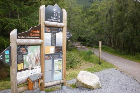
Park at the North Face car park and follow the signposted markers through the forest for the Allt a' Mhuilinn trail. The path crosses a bridge over a river and the trail soon leads off on another path to the right. This path loses little time in gaining height with some steep sections as it winds its way up through the coniferous trees of the Leanachan Forest. An optional extra to the right is a fifty metre digression to see a viewpoint overlooking Fort William and the bay beyond. After passing a river on the right with some waterfalls, the path emerges from the forest at a wooden stile and then continues up the valley ahead with the cliffs of Ben Nevis (if they are not swathed in cloud, as they often are) on the right while the whaleback shape of Carn Mor Dearg is on the left. There is not a right or a wrong way of gaining the height to reach the Carn Mor Dearg ridge. It is down to the individual to pick a route that best suits them across pathless terrain with safety a key consideration. Even this is a subjective matter up to a point as a steep rugged climb may seem like a straightforward challenge to one person while another may find it difficult, depending on their past experiences and their perception of the terrain in front of them.
This route follows the path ahead as it winds its way up the valley with the Allt a' Mhuilinn river on the right. The scenery becomes more interesting as progress is made with some cascades appearing on the river and the dramatic cliffs and snow patches of the north face of Ben Nevis starkly apparent on the right. Another path, from the half way lochan, merges from the right and joins up shortly before the CIC mountaineering hut is reached. Note that any further height gain up the valley from here is offset by the fact that beyond this point, the task of heading up the slopes to the left becomes steeper, rockier and trickier. According to one walk route description, the one redeeming feature of this relentlessly steep slope is the view back across the valley to the Ben Nevis massif. In fact, there is nothing else quite like this view on the UK mainland and it bears some similarity to the Alps. Even in summer you can expect to see great patches of snow among the cliffs, crags, and rock buttresses with Gardyloo Gully being especially noticeable.
If you decide that to go on up to the ridge is not for you, this is the time to turn back as this is where the going gets serious in terms of terrain and gradient. As there is no path, you need to pick your own route up amid rocks, scree, grass and some shallow gullies. It is up to you to decide what you feel most comfortable with, bearing in mind that rocks and stones can be loose, therefore grass tends to be the safer option. The gradient does not ease off until you are about a hundred yards from the top of the ridge, by which time you finally have sight of the summit ridge ahead of you rather than more steep slope to be negotiated. Looking behind you, there are spectacular views of Ben Nevis's cliffs across Coire Leis. Although the top of the ridge cannot be seen until a few minutes before you reach it directly ahead, there is a clue as to how near you are getting by looking at the stony ridge to the right, the Carn Mor Dearg arete, sometimes with tiny figures walking along it.
Once you have reached the summit ridge, the walk to the summit of Carn Mor Dearg seems easy after the long, steep toil up from the Coire Leis valley. There are three tops on the ridge, the other two being Carn Dearg Meadhonach and Carn Beag Dearg. Although there is a steep drop down to the east, the ridge is reasonably wide, a sandstone red shade of colour and stony. Despite Carn Mor Dearg being one of the top ten highest mountains in the UK, the summit cairn is only small but this seems insignificant as the views all around are quite breathtaking. The cairn itself is just a few feet away from a big, though not sheer, drop to the east. Ben Nevis and its north face dominates the view to the west and you may see tiny figures on the top of "The Ben". You can also look down on the Carn Mor Dearg arete to the south-west and the broad ridge of Aonach Mor to the east reveals its steep west flank with various gullies running down it.
The return route descends via Carn Dearg Meadhonach and Carn Beag Dearg to eventually rejoin the path up the Allt a' Mhuilinn valley and then back to the car park through the forest.
Other walks nearby
| Walk 2918 | Aonach Mor and Aonach Beag - two of the "Lochaber giants" | mod/hard | 9.0 miles |
| Walk 2105 | Ben Nevis via Carn Mor Dearg arete | hard | 10.5 miles |
| Walk 3270 | Ben Nevis | mod/hard | 9.7 miles |
| Walk 1338 | Ben Nevis Tourist Path | mod/hard | 8.7 miles |
| Walk 3303 | Mamores Ridge - Stob Ban, Am Bodach and Sgurr an Iubhair | hard | 9.0 miles |
| Walk 3095 | Stob Ban (Mamores) | mod/hard | 6.0 miles |
| Walk 2824 | Arkaig Hills Circular | moderate | 8.8 miles |
| Walk 3106 | Binnein Mor from Kinlochleven | hard | 10.2 miles |
| Walk 1039 | Am Bodach and Stob Coire a' Chairn | mod/hard | 9.5 miles |
| Walk 1094 | Blackwater Reservoir | moderate | 11.5 miles |
Recommended Books & eBooks
Skye's Cuillin Ridge Traverse
 This 2-volume set provides all the information required to complete the main ridge traverse on Skye's Black Cuillin. Strategy, gear, training, navigation and logistics are covered, and 10 classic scrambles are described. A lightweight second guidebook gives the scrambler detailed maps, topos and route description for the ridge traverse itself.
More information
Walking in Torridon
 This guidebook contains 52 day walks in Torridon, a remote and much-loved area of the Scottish Highlands. Based around Shieldaig and Slioch, the routes are split into 3 sections: easy walks, long and high level walks and mountain ascents over 2000ft including 9 Munros, and 5 outline suggestions for major ridge walks.
More information
Messaging & Social Media
Message Walking Britain and follow the latest news.

Mountain Weather
Stay safe on the mountains with detailed weather forecasts - for iOS devices or for Android devices.