Bennachie and Mither Tap from Bogend
Aberdeenshire Walk
County/Area - Aberdeenshire
Author - Lou Johnson
Length - 6.0 miles / 9.8 km Ascent - 1600 feet / 485 metres
Time - 4 hours 40 minutes Grade - moderate
Walk Route Description
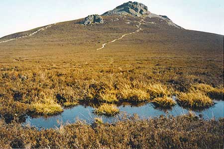
Click image to see photo description.
This fine walk to the west of Inverurie offers some fine views and excellent walking. The start of the route is the Back o' Bennachie car park and picnic area (grid ref. NJ661245) where charges apply. The start is reached down a minor road running south from the B9002 just west of Bogend. The route should be saved for fine weather as good visibility provides much wider views across the surrounding countryside and hills.
After parking follow the path south following the signs for the Mither Tap Quarry Trail. The path climbs beside Gillree Burn through forest to reach open hillside. Continue uphill to Little Oxen Craig, the first of four summits visited during the walk before continuing south to Oxen Craig (grid ref. NJ663226), which also the highest point on the walk.
From here descend east and continue across moorland before turning southeast to the rocky summit of Mither Tap with its hilltop fort dating back over 2000 years. To start the return route, continue through the gateway to the fort and head north for just under half a mile to a junction (grid ref. NJ681230). Here bear left and continue in a westerly direction, to reach in a further half a mile the final summit of the walk, Craigshannoch.
Leave this minor top in a south-westerly direction towards Oxen Craig. The path contours around Gill Well, turning northwest to re-join the outward route on the approach to Little Oxen Craig. From here retrace your steps down to the start following signs for Back o' Bennachie.
Maps 

| Ordnance Survey Explorer 421 | Sheet Map | 1:25k | BUY |
| Anquet OS Explorer 421 | Digital Map | 1:25k | BUY |
| Ordnance Survey Digital Map Subscription | |||
| Latest Ordnance Survey Discounts | |||
Other walks nearby
| Walk 1771 | Ladder Hills Circular | mod/hard | 9.5 miles |
| Walk 1897 | Sandend to Cullen Coast Path | easy/mod | 5.0 miles |
| Walk 1956 | Moray Coast Trail - Cullen to Portessie | easy/mod | 6.3 miles |
| Walk 1777 | Carn Daimh from Glenlivet | moderate | 8.5 miles |
| Walk 2181 | Loch Lee & Falls of Unich | mod/hard | 10.7 miles |
| Walk 3108 | Creag Choinnich circular | easy/mod | 4.0 miles |
| Walk 2706 | Morrone (Morven) | moderate | 7.4 miles |
| Walk 1864 | Glen Quoich & Glen Lui (near Braemar) | moderate | 10.0 miles |
| Walk 2031 | Abernethy Forest, Cairngorms | easy/mod | 10.2 miles |
| Walk 1119 | Ben Macdui & Carn a' Mhaim | hard | 19.0 miles |
