Garway Hill Common & Kentchurch
Herefordshire Walk
County/Area - Herefordshire
Author - Lou Johnson
Length - 6.3 miles / 10.2 km Ascent - 1200 feet / 364 metres
Time - 4 hours 20 minutes Grade - easy/mod
Walk Route Description
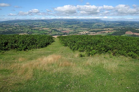
Click image to see photo description.
This Herefordshire walk to the summit of Garway Hill and through the surrounding countryside offers some wonderful scenery, which lies between Ross-on-Wye and Hereford. The view from Garway Hill's summit is particularly notable including views into five counties on a clear day including eastern edge of the Brecon Beacons National Park, and the Gloucestershire Hills.
The start is the small car park at Lower Castre (grid ref. SO443247) reached down a track from Sun Farm on the lane running just east of Garway Hill. After parking follow the wide path heading north-east uphill to reach the summit of Garway Hill passing Black Pool on your right along the way. The summit has a trig point and the remains of an old radio station. Take time to enjoy the view which is outstanding.
The onward route runs north-east along the ridge following the Herefordshire Trail to pass a radio mast. Continue ahead downhill to reach a track (grid ref. SO441261). Turn right down to a road (grid ref. SO441260). Turn left along the road following the Herefordshire Trail. Continue past Garway Methodist Church on your right and continue ahead at the road junction immediately after. Just over 120 metres from this junction take the signed footpath on the left adjacent to a pair of metal gates (grid ref. SO442265). The path heads west and passes just to the north of Burnt House Wood and then continues to pass Court-a-grove Farm on your right. The onward path continues west to reach Bannut Tree Farm and road which is reached after crossing a stone bridge (grid ref. SO423262).
Turn left along Bannut Tree Lane. After 700 metres you reach a road junction (grid ref. SO419257). Bear left following the Herefordshire Trail soon passing the very attractive Kentchurch parish church on your right and the entrance drive to Kentchurch Court on your left. For a brief section the River Monnow (the England Wales border) runs beside the road to your left. Pass Great Corras Farm on your left and follow the lane uphill with Garway Hill in view ahead to a sharp right-hand bend (grid ref. SO423248).
Take the waymarked path on the left through a metal gate and onto a track. The path bears right and then follows the edge of Copse Wood before climbing up to skirt the northern edge of Little Corras Wood to head East to reach the southern flank of Garway Hill Common. Turn left following the waymarked Herefordshire Trail up hill to revisit the summit of Garway Hill from where you can enjoy the view which includes much of the area that you have just explored on foot. To return to the start, turn right at the trig point and follow the clear path downhill past Black Pool.
Maps 

| Ordnance Survey Explorer 189 | Sheet Map | 1:25k | BUY |
| Anquet OS Explorer 189 | Digital Map | 1:25k | BUY |
| Ordnance Survey Digital Map Subscription | |||
| Latest Ordnance Survey Discounts | |||
Other walks nearby
| Walk 3723 | Garway Hill from Kentchurch | easy/mod | 6.4 miles |
| Walk 3622 | Llanthony Priory from Longtown | mod/hard | 7.0 miles |
| Walk 2670 | Ysgyryd Fawr (The Skirrid) near Abergavenny | easy/mod | 3.5 miles |
| Walk 2751 | Goodrich Circular | easy/mod | 6.5 miles |
| Walk 3214 | Symonds Yat, High Meadow Woods & Wye Valley | moderate | 12.0 miles |
| Walk 3302 | Symonds Yat Rock and the Biblins | easy/mod | 4.0 miles |
| Walk 1237 | Cwmyoy & Hatterrall Hill from Llanthony Priory | moderate | 10.0 miles |
| Walk 3203 | Vale of Ewyas from Llanthony Abbey | moderate | 10.7 miles |
| Walk 3342 | The Hatterall Ridge from Llanthony Priory | very hard | 10.0 miles |
| Walk 2192 | Wye Valley Walk | easy/mod | 6.6 miles |
