Garway Hill from Kentchurch
Herefordshire Walk
County/Area - Herefordshire
Author - Lou Johnson
Length - 6.4 miles / 10.4 km Ascent - 1100 feet / 333 metres
Time - 4 hours 20 minutes Grade - easy/mod
Walk Route Description
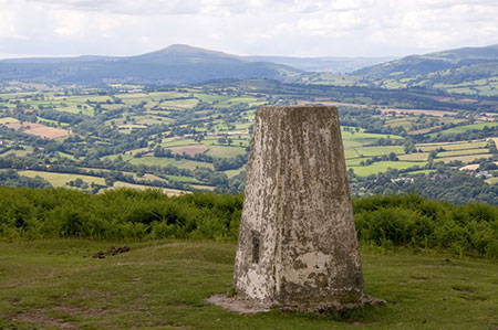
Click image to see photo description.
The main objective of this Herefordshire circular walk is the summit of Garway Hill from where there are views into five counties on a clear day including the eastern edge of the Brecon Beacons National Park, and the Gloucestershire Hills. The route follows part of the Herefordshire Trail and passes through some fine scenery throughout.
The start is the Bridge Inn in Kentchurch (grid ref. SO410258). After parking exit the car park and turn right along the B4347. At the first junction where the B4347 bends right, continue ahead along a lane signed to Garway. After800 metres you reach a junction where you keep right soon passing St, Mary's Church on your right. Continue along the lane for a further kilometre. For a brief section, the River Monnow (the England Wales border) runs beside the road to your left. Continue past Great Corras Farm on your left and follow the lane uphill with Garway Hill in view ahead. Reaching a sharp right-hand bend (grid ref. SO423248) turn left off the road to follow the waymarked Herefordshire Trail.
Take the waymarked Herefordshire Trail through a metal gate and onto a track. The path bears right and then follows the edge of Copse Wood before climbing up to skirt the northern edge of Little Corras Wood before heading East to reach the southern flank of Garway Hill Common. Turn left following the waymarked Herefordshire Trail up hill to the summit of Garway Hill from where you can enjoy the view which includes much of the area that you are exploring on foot.
The summit has a trig point and the remains of an old radio station. Take time to enjoy the view which is outstanding. The onward route runs north-east along the ridge following the Herefordshire Trail to pass a radio mast. Continue ahead downhill to reach a track (grid ref. SO441261). Turn right down to a road (grid ref. SO441260). Turn left along the road following the Herefordshire Trail.
Continue past Garway Methodist Church on your right and continue ahead at the road junction immediately after. Just over 120 metres from this junction take the signed footpath on the left adjacent to a pair of metal gates (grid ref. SO442265). The path heads west and passes just to the north of Burnt House Wood and then continues to pass Court-a-grove Farm on your right. The onward path continues west to reach Bannut Tree Farm and a road which is reached after crossing a stone bridge (grid ref. SO423262).
Turn left along Bannut Tree Lane. After 700 metres you reach a road junction (grid ref. SO419257). Turn right and retrace your steps back to the start.
Maps 

| Ordnance Survey Explorer 189 | Sheet Map | 1:25k | BUY |
| Anquet OS Explorer 189 | Digital Map | 1:25k | BUY |
| Ordnance Survey Digital Map Subscription | |||
| Latest Ordnance Survey Discounts | |||
Other walks nearby
| Walk 3243 | Garway Hill Common & Kentchurch | easy/mod | 6.3 miles |
| Walk 3622 | Llanthony Priory from Longtown | mod/hard | 7.0 miles |
| Walk 1237 | Cwmyoy & Hatterrall Hill from Llanthony Priory | moderate | 10.0 miles |
| Walk 3203 | Vale of Ewyas from Llanthony Abbey | moderate | 10.7 miles |
| Walk 3342 | The Hatterall Ridge from Llanthony Priory | very hard | 10.0 miles |
| Walk 2670 | Ysgyryd Fawr (The Skirrid) near Abergavenny | easy/mod | 3.5 miles |
| Walk 3204 | Hay Bluff & Twmpa | moderate | 10.3 miles |
| Walk 2935 | Llanthony Priory from Capel-y-ffin | easy/mod | 7.7 miles |
| Walk 1660 | Craswall Priory & Hay Bluff | easy/mod | 6.0 miles |
| Walk 1271 | Sugar Loaf circular | moderate | 6.0 miles |
