Rockcliffe to Sandyhills
Dumfries and Galloway Walk
County/Area - Dumfries and Galloway
Author - Lou Johnson
Length - 5.0 miles / 8.1 km Ascent - 600 feet / 182 metres
Time - 3 hours 10 minutes Grade - easy/mod
Walk Route Description
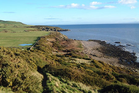
Click image to see photo description.
This walk from Rockcliffe in Dumfries and Galloway explores a beautiful, rugged, and interesting section of the Colven Coast east to Sandhills. The route follows the coast path and offers views across the Solway Firth to the Lake District. With varied flora and fauna, scenic variety and other points of interest, this route is often said to be the finest coastal walk in Scotland.
The start is the car park at the eastern end of the beach in Rockcliffe (grid ref. NX847537). After parking walk along the road with the sea to your right. A short distance offshore is Rough Island. Continue to the east end of the beach and turn right along a lane signed to the Merse and Castle Point. Pass the houses on your left and continue to the end of the lane. Continue ahead along a signed footpath which runs along the top of the beach around Portobeagle Bay. The path continues to the left over a rocky section passing the grave of Joseph Nelson who was shipwrecked in 1791.
The onward path heads uphill across a field to reach Castlehill Point where an information board explains the history which included an Iron Age Fort. The headland also offers an excellent view across the Solway Firth. Continue east along the path along the cliff tops of Barcloy Heigh. The route continues across the flank of Barcloy Hill before descending to Bogle Hole. Continuing east you pass a stone cross commemorating the life of Captain Samuel Wilson who perished in a shipwreck.
The route continues across fields passing through several gates before climbing steeply onto the side of White Hill. The route descends steeply including a stepped section down to Port o' Warren. Turn left uphill along a narrow lane to Portling. After 500 metres, turn right down a road signed to Sandyhills. Nearing the shore turn left up steps by a fingerpost. The path then climbs steadily onto Torrs Hill, another excellent viewpoint. Another information board provides details of the immediate vicinity. The route then descends through several gates and more steps to cross a footbridge leading to Sandyhills beach. Depending on tides you can turn left and visit the Needle's Eye natural arch. Continue ahead keeping the caravan park on your left. You soon reach the main road and car park (grid ref. NX891593).
As this a linear walk you either need to use two cars or use the no.372 bus service between Rockcliffe and Sandhills. The bus service is not that frequent with buses every 2 hours during the week and three services on Sundays. Do check the timetable at bus timetable. I chose to park at Sandyhills, just in time to catch a bus to Rockcliffe as this avoided the possibility of a long wait at Sandhills for a return bus.
Maps 

| Ordnance Survey Explorer 313 | Sheet Map | 1:25k | BUY |
| Anquet OS Explorer 313 | Digital Map | 1:25k | BUY |
| Ordnance Survey Digital Map Subscription | |||
| Latest Ordnance Survey Discounts | |||
Other walks nearby
| Walk 3552 | Grune Point from Silloth | easy | 4.7 miles |
| Walk 1302 | Low Fell and Fellbarrow from Loweswater | easy/mod | 6.0 miles |
| Walk 3558 | St Bees to Whitehaven coast path | easy/mod | 7.4 miles |
| Walk 1671 | Grike & Crag Fell | easy/mod | 6.6 miles |
| Walk 1290 | Mellbreak | moderate | 7.0 miles |
| Walk 3676 | Hen Comb from Loweswater | moderate | 5.4 miles |
| Walk 2658 | The Machars Peninsula - St Ninian's Cave | easy | 2.0 miles |
| Walk 1676 | Ullock Pike, Long Side and Carl Side | moderate | 5.5 miles |
| Walk 2058 | Ennerdale Skyline incl. Steeple & other fells | mod/hard | 13.8 miles |
| Walk 3667 | Ennerdale Water Circular | moderate | 7.1 miles |
