The Machars Peninsula - St Ninian's Cave
Dumfries and Galloway Walk
County/Area - Dumfries and Galloway
Author - Eric Lucas
Length - 2.0 miles / 3.3 km Ascent - 200 feet / 61 metres
Time - 1 hours 10 minutes Grade - easy
Walk Route Description
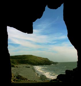
Click image to see photo description.
This short walk takes you down to the shore on the Machars Peninsula to explore a cave that has significant religious and historic connections for Scotland. The going is easy and you should encounter no problems with navigation. To reach the start take the A747 from Port William east towards Isle of Whithorn. Go straight on at Glasserton War Memorial (grid ref. NX424383) and continue until you come to a single track road on the right (grid ref. NX439381). Follow this road to a Car Park on your left (honesty box) at grid ref. NX431366.
After parking walk left along a footpath signed to St Ninian's Cave. Follow this path through Physgill Glen to the shore. Here you turn right to the Cave. After viewing the Cave you then re-trace your steps back to the car park. The walk offers good views of Isle of Man and, on a clear day, the Lake District Fells. You may well see grey seals just offshore. The cave is said to have been used for prayer and meditation by St Ninian who first brought Christianity to Scotland founding the first monastery at Whithorn around AD500. Today there is an annual pilgrimage to the Cave and it is visited by many people because of its significance to Christianity. Call in at the Visitor Centre in Whithorn on your way back and view the excellent audio visual presentation on the history of Whithorn and its connection with St Ninian whilst enjoying some refreshment.
Maps 

| Ordnance Survey Explorer 311 | Sheet Map | 1:25k | BUY |
| Anquet OS Explorer 311 | Digital Map | 1:25k | BUY |
| Ordnance Survey Digital Map Subscription | |||
| Latest Ordnance Survey Discounts | |||
Other walks nearby
| Walk 2068 | Maxwell's Otter and Monreith Beach | easy | 6.0 miles |
| Walk 1718 | Mull of Galloway circular | easy | 6.0 miles |
| Walk 2623 | Merrick from Glen Trool | mod/hard | 8.0 miles |
| Walk 3316 | Rockcliffe to Kippford | easy | 3.0 miles |
| Walk 3290 | Rockcliffe to Sandyhills | easy/mod | 5.0 miles |
| Walk 3558 | St Bees to Whitehaven coast path | easy/mod | 7.4 miles |
| Walk 1745 | Grike and Caw Fell from Kinniside Stone Circle | mod/hard | 13.5 miles |
| Walk 1671 | Grike & Crag Fell | easy/mod | 6.6 miles |
| Walk 2058 | Ennerdale Skyline incl. Steeple & other fells | mod/hard | 13.8 miles |
| Walk 3667 | Ennerdale Water Circular | moderate | 7.1 miles |
